Eng-Tips is the largest engineering community on the Internet

Intelligent Work Forums for Engineering Professionals

  • Congratulations waross on being selected by the Tek-Tips community for having the most helpful posts in the forums last week. Way to Go!

Conditions to Justify Residential Slope Assessment

Status
Not open for further replies.

mudandsnow

Electrical
Nov 12, 2015
77
0
0
CA
I want to buy a house but there is a hill behind it. If it needs a retaining wall, I don't want to buy it.

If it most likely needs a wall, I will probably walk away before spending money on assessment.

I'm sure this is hard without seeing it in person but any rough guess would be appreciated. What are the odds that it will need a retaining wall?

What factors do you consider when deciding whether a hill should be assessed or not?
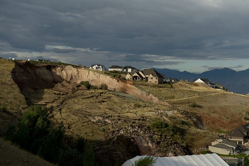
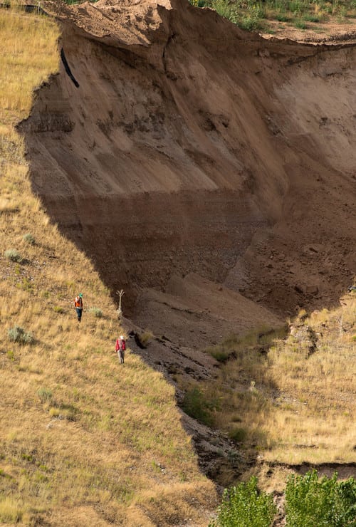
Slope: about 45°
Height: about 100ft
Soil Type: silt
Vegetation: grass and small shrubs
Above the hill: flat orchard / vineyard
Climate: Western Canada, multiple freeze thaw cycles in spring and fall and snow melt water runoff in spring.
Features: looks like there used to be a 1 car wide road diagonally up the hill. Does that mean it's packed down and thoroughly tested?
House age: 50 years

I don't think the hill has moved in the 50 years the house has been there but there have been slides in the area lately, often in spring and usually attributed to snow melt runoff and multiple freeze thaw cycles.
 
Replies continue below

Recommended for you

How did you measure that 45 degrees? The eye can be very wrong. Are there any old timers around that may recall anything there? Sometimes small slides can be seen by the appearance of the surface topography. Providing a rough sketch here with a cross section view would help. Any ground water info? If you are quite serious, you might hire a geotech firm to take a boring or two and do some lab testing of undisturbed samples so a conventional slope stability study can be done. The history that you describe sounds promising.
 
Thank you for your reply. Measured 45° with my untrained eye. Actually looks a bit less than 45°. I could go out there with a laser rangefinder and get a more accurate estimate.

It's pretty flat, doesn't look like there are any old slide paths and the old road has a consistent width (doesn't have any cuts in it).

Don't know any old timers but am hoping to talk to the city about it.
 
If the hill is a natural deposit, maintains vegetation and there is no groundwater seeping out the toe of slope should be no immediate problem.

Slope failures occur when owners start cutting into the toe of slope which causes instability. Note if the bottom portion of the slope is steeper than the top portion that is not a good sign. A steep upper portion and bulge at the bottom is also not a good sign.

Also with retaining walls, the wall designers worry about the wall and not the slope falling over.

The first stage of site investigation is desktop and it informs the engineer of the anticipated subsurface conditions. By precluding the site investigation the design engineer cannot accept any responsibility for providing a safe and economical design.
 
Sounds like there could be an issue, but maybe not. You should get a qualified engineer to walk the site with you. Someone with a well trained eye should be able to see if anything is alarming. You may be able to get someone to look at it for a couple of hundred, depending on what you want from them. A subsurface investigation and a survey would have to be completed to really know if there is a slope stability concern.

I'm not familiar with the climate but if the slope is steep enough and you get a fair amount of rain you may also have a debris flow issue.
 
get a better measurement of the slope and recommend that you determine more accurately whether this is silt or silty sand or silty clay or something else. is it plastic and what is the PI? a geologic map would be useful.

you need a significant amount of water to trigger the frontal wave of a debris flow, you should be well away from any streams coming off this hill.

a retaining wall will not hold up the hill, you need to determine if the house is far enough away from the hill to be safe. observe the recent slides in the area to determine size and extent

50 years is a long time with a good track record, so it is likely not an immediate concern.

 
Thanks for the replies everyone. I used GIS to measure slope of 33° (rise = 19m, run = 29m). Not sure how accurate that is but seems believable. The plateau that looks like an old road shows up in the contour lines. See picture 10 and 11 for contours.

I'm going to try to upload 11 pictures.

Pictures Summary:
3 - looks like shed and tree are leaning towards house. Could that be from toe bulge or anything else worth concern?
10 and 11 - contour lines

1: close up straight

2: close up angled

3: close up cross

4, 5: street view

6 - 9: area

10: 1m contours of surrounding area

11: 1m contours with rise and run


Interesting photos - I would not want any structures at the immediate toe of that slope...the hummocky bulges on the slope suggest to me that it has failed in the past, even taking into consideration that an access road was once there.

Point is though, you could never retain an unstable slope of that scale- what you would need to do is to walk the site with someone in the know, ideally a geotechnical professional, and confirm that your structures are positioned far enough from the embankment toe that they are out of harm's reach if any movement occurs.

Most slopes that have already failed are pretty much at equilibrium...they are unlikely to move significantly further unless they are modified by excavation, surcharge loading or alternatively, subject to some sort of liquefaction and subsequent debris flow...I couldn't comment on the chances of that as I'm not a local.

All the best,
Mike
 
The one photo that shows a profile of the slope measures at 30 degrees. That is a typical stable angle of friction )(as resulting in a slope) for granular type soil. The air photos show typical "cat's paw" type erosion patterns for wind blown silt. I'd say that slope is stable as long as erosion is controlled by vegetation. Seeing the many developments also tells me you have nothing to worry about. I'd go for it. Your photos tell a lot.
 
Looking at photo 3 large tree in background appears to be leaning, not a good sign for the tree, photo 4 shows it leaning towards the property.
Looking at photo 10 the topography is steeper and has an outward curve which reduces 3d beam strength to the neighbor on the right on photo. Neighbor on the left on photo is more on the inward curve which is more stable position. Possible past failure or drainage /erosion gully occurring in photo 10 on the bottom where the contours are curved into the hill.
Looking at photo 6 on the left of the photo shows inferred failures with vegetation displaced down slope in a shallow failure and mostly a coarse grained or silty sand deposit being eroded away. These type of shallow failures are more nuisance cleanup and cause some damage but not catastrophic usually. In the background of photo 6 you see two indents into the topography caused by drainage gullies which eventually led to slumps. Those failures take along time to develop and can be mitigated by grading and vegetating erosion gullies on the slope, these slumps can cause significant damage.

In my opinion taking into account the water level of the lake, if a slope failure were to occur it would be a shallower slide probably most susceptible at the neighboring property, which has steeper topography, this type of failure is more nuisance cleanup than real hazard to the buildings. Don't see any warning signs to say deeper failures would occur, but a site investigation might prove otherwise. If the lake floods causing a higher groundwater table could maybe see a larger slide probably most susceptible at the bottom left of photo 10 where the contours from the hill have a sharp outside curve and are closest to the water.

Hope this helps.


The first stage of site investigation is desktop and it informs the engineer of the anticipated subsurface conditions. By precluding the site investigation the design engineer cannot accept any responsibility for providing a safe and economical design.
 
Without robust geo (subsurface) knowledge, I would definitely look for a home elsewhere.
Like common financial advice, past performance does not predict future results.
Large slope failures are like plane crashes. Very rare, but when they occur, the effects are devastating.
Just about every year, hundreds of people are buried alive by landslides. Slopes that were previously stable for decades if not centuries.
Not so much in the US. But I've pasted an example of a slope failure from 2014 in Utah - less than 2H:1V - where the residents got awfully lucky and just property damage was the result. The good news is that the slide is quite loud and not too fast, and gave residents some escape time.
N_Salt_Lake_City_Landslide_August_2014_archive.sltrib.com_1_kchanc.jpg
N_Salt_Lake_City_Landslide_August_2014_archive.sltrib.com_2_mjdcci.jpg
N_Salt_Lake_City_Landslide_August_2014_fox13now.com_6_before_after_xqfzn7.jpg
 
I'd not depend on a local on-site geotech investigation to predict what is shown above. Since it is very likely this whole area is the same for geology, what is available in the general area locally to look for major movements as the photo shows. Go to see cat's paw erosion areas and see what goes on. For instance at the photos above, were there any recent constructions that affected it? The houses appear new. Ground water many times is in the picture for such slips.
 
Eaglepoint landslide

apparently this slide was an accident waiting to happen due to geologic conditions which were terrible. this is perfect example why a geologist or geotech should be the one to give an opinion

[URL unfurl="true" said:
https://blogs.agu.org/landslideblog/2014/08/12/eaglepointe-1/[/URL]]The slide mass consists of sands and gravels of the Lake Bonneville highstand, overlain atop Tertiary volcanic tuff – the latter is a notorious material for landslides in the northern Utah, the so-called Norwood Tuff. It weathers to swelling, water-sensitive clays.

The development was a gravel quarry until the late 1990’s, and the area that slid was the highwall or maximum extent of quarrying. It had been graded at 2:1 (~25 degrees). The houses threatened were built in the mid-2000’s.

 
I disagree that just because a slope has been there for decades that it is safe. There is a lot to take in here. Is the green space on top of the slope designated for development? That could be an issue down the line if the developed site(s) is heavily irrigated. I would get a professional involved if you are seriously concerned.
 
If you hire a geotech, make sure he has experienced backing or does have many years experience. This is not simply interpreting some test borings. While you are at it review the backgrounds of us here.
 
Thanks everyone for the help. You are all more helpful than the local pros. The one that replied just said they are busy until 2019. We are going to back out for now and try to book an appointment 2019 to assess that property if it's still available or maybe get a discussion about local geo hazards.
 
To cvg: Hindsight has amazing clarity. While we agree that this site had potential problems, how many engineers stood up and made an issue with the local jurisdiction (before the slope fail)? Several engineers in the private sector and public sector had sufficient information to evaluate and render a profession judgment.

90% or more of geo engineers would tell you that if the slope is flatter than 2H:1V, don't worry about - even if the soil is monkey poop.
The geo data recon and lab testing necessary to render a high-confidence opinion on a questionable slope is disproportionate to the value of most single family dwellings.
Even in mountainous regions there's a few flat spots. Let the liberal studies majors build near the slopes.
 
ATSE said:
90% or more of geo engineers would tell you that if the slope is flatter than 2H:1V, don't worry about - even if the soil is monkey poop.

I must be in the minority. 3H:1V or flatter would be in the zone that I start to feel comfortable for permanent slopes with poor soil and groundwater. You probably can do short-term slopes for construction at 2H:1V with poor soil, but to rest my hat on a permanent slope without doing an analysis and with implications of killing someone wouldn't sit right with me.
 
Status
Not open for further replies.
Back
Top