Eng-Tips is the largest engineering community on the Internet

Intelligent Work Forums for Engineering Professionals

Rational method

Status
Not open for further replies.

lKobRal

Civil/Environmental
Apr 16, 2019
17
0
0
RU
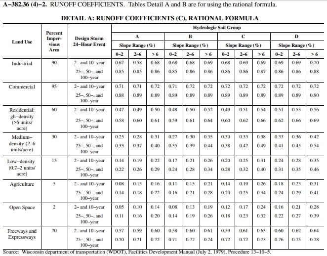
Please explain what the parameter "Percent Impervious Area" means and how to use it when calculating the runoff coefficient?
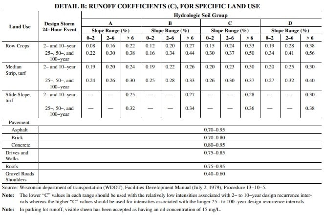
Why do the values of runoff coefficients for different soil groups (A,B,C,D) differ depending on the land use?
Please give an example of calculating the runoff coefficient for areas with mixed land use, in particular when commercial and industrial areas are used.
_jD--MVcASs_xku8fo.jpg

tMNjznLBkQE_kpxcln.jpg

In all the documents that I studied, the depth of the pipe depends only on the depth of freezing of the soil or equal to it. Is there really no other circumstances that affect the depth of the pipe and how is it calculated? I correctly understand that the depth of the pipe is always taken equal to the depth of freezing of the soil?
In many documents that I studied, the minimum velocity in a sewer pipe is 2 feet per second, do I understand correctly that a minimum speed of 2 feet per second is suitable for all diameters, and not just minimum ones?
This table shows the minimum slopes for pipes of different diameters, please explain how these minimum slopes are regulated, as I understand it, the minimum slopes give a minimum speed of 2 feet for pipes with appropriate diameter. Or are these minimum diameters dictated by the design features of the pipe?
Slope_tn0fh2.png
 
Replies continue below

Recommended for you

1. "Percent Impervious Area" is pretty self explanatory. It is the percentage of the area with impervious coverage. It can be useful for determining the correct Land Use (for example, some Industrial or Commercial may be far less coverage than 90-95%).

2. The better Hydrologic Soil Group rating, the lower the runoff potential (for example, less runoff from well drained sand than clays). Also, the more impervious, the greater runoff potential. So, the charts you reference are combining these factors.

3. For mixed land use, I would either:
a. pick a use that approximates the actual impervious percentage.
b. calculate the compound coefficient using individual cover areas (grass, paving, roofs, etc.)

4. The structural integrety of the pipe is a significant determining factor for depth of pipe. There is typically minimum depth requirements for particular loads published by manufacturers and/or regulatory agencies.

5. It is assumed that a minimum velocity of 2 fps will help keep sediments from accumulating in the pipe. This is typically calculated using Manning's equation. Velocity will vary with size, slope, and roughness coefficient for a given flow. The chart you provided is the slope that will provide the minimum at each size when flowing full for a specific roughness coefficient.
 
Unfortunately, I did not understand your determination of the runoff coefficient. Let's look at a specific example. For example, there are street, green spaces and high-density residential development in watershed area. The runoff coefficient for the street (asphalt pavement) is (0.7-0.95), what is the runoff coefficient for green spaces (this is not in the table)? For high-density residential development, the percent impervious area is 60% (that is, the composition on the plots is 60% asphalt), and the remaining 40% what is filled with? The biggest difficulty arises with residential buildings with high density, if 60% is occupied by asphalt, then all 40% of the rest is green? Or 60% is the runoff coefficient?
 
To get a runoff coefficient for an area with a variety of items, perform a weighted average based upon the land use types. For example, if your watershed consists of 65% High-density Residential, 5% park (Open Space), 25% commercial and 5% interstate; the runoff coefficient would be the following: 65% (60) + 5%(2) + 25%(95) + 5%(70) = 66.35. You normally don't count the roads, driveways, parking lots, yards, etc. because they are incorporated into the runoff coefficient of the different land use items (e.g., parking lots would be incorporated into the area used for commercial or industrial use; yards and driveways are included in the residential area).
 
Thank you very much, I understood your explanation. But I had one last question: the runoff coefficient for commercial and residential areas is different, although the hydrological group is the same (for example hydrological group A in the fourth column)???
 
My example was slightly off in that I did the weighted average on the Percent Impervious Area and not the runoff coefficient.

In order to calculate the runoff coefficient, you need to know the % of the area of the different Land Use Types; what type of storm event (2 & 10 vs 25, 50 or 100), Hydrologic Soil Type (A, B, C or D) and the slope of the land. Using the example of a watershed consisting of 65% High-density Residential, 5% park (Open Space), 25% commercial and 5% interstate; All of the soils are Type A; for the 25-year storm; and the slope is 2 - 6 percent the runoff coefficient would be the following:
65%(0.60) + 5%(0.16) + 25%(0.89)+5%(0.71) = 0.656

Depending your watershed, you could have multiple soil types, slope ranges, etc. that would cause the formula more complicated (e.g., if the slopes in the residential was 20% <2% and 80% 2-6%, the formula for the residential portion of the runoff coefficient calculation would be 65%(20%*0.58+80%*0.60)). If you are wanting to determine the maximum runoff, you could take the conservative approach and just use the higher number (i.e., 65%(0.60)).
 
Thank you for your detailed and very thorough answer! Now I understand everything about the runoff coefficient.

1. I would also like to ask a question about the slopes that are used in the hydraulic calculation of rainwater networks. As far as I understand, the estimated bias of the rainwater drainage network can be accepted by anyone, provided that it provides Vfull>Vmin and Qfull>Qdes For example, 0.001; 0.0015; 0.002; 0.0025; 0.003; 0.0035; 0.004; 0.0045; 0.005 and so on. Or even 0.0011; 0.0012; 0.0013; 0.0014; 0.0015; 0.0016; 0.0017; 0.0018; 0.0019 i.e. a finer ranking than in the example above. That is, modern equipment during the construction of the network can provide such a small ranking (0,0014; 0,0015; 0,0016) and can create any slope of the pipe?

2. And as far as I understand, is the maximum maximum rainfall rate in the rainwater drainage network 12 feet per second?
 
To get a runoff coefficient for an area with a variety of items, perform a weighted average based upon the land use types. For example, if your watershed consists of 65% High-density Residential, 5% park (Open Space), 25% commercial and 5% interstate; the runoff coefficient would be the following: 65% (60) + 5%(2) + 25%(95) + 5%(70) = 66.35. You normally don't count the roads, driveways, parking lots, yards, etc. because they are incorporated into the runoff coefficient of the different land use items (e.g., parking lots would be incorporated into the area used for commercial or industrial use; yards and driveways are included in the residential area).

In order to calculate the runoff coefficient, you need to know the % of the area of the different Land Use Types; what type of storm event (2 & 10 vs 25, 50 or 100), Hydrologic Soil Type (A, B, C or D) and the slope of the land. Using the example of a watershed consisting of 65% High-density Residential, 5% park (Open Space), 25% commercial and 5% interstate; All of the soils are Type A; for the 25-year storm; and the slope is 2 - 6 percent the runoff coefficient would be the following:
65%(0.60) + 5%(0.16) + 25%(0.89)+5%(0.71) = 0.656

Tell me, please, in the end, what is the correct use of land uses, residential development of commercial industrial or types of soils?
 
1. For the slope of the pipe, normally a minimum of 2% slope is required. There may be rules/regulations specifying a minimal slope for the sewers. Additionally, there may be maximum velocities for the contents to prevent scouring of the pipes. Finally, if you're dealing with pressurized systems (e.g., force mains) you'll will be dealing with additional issues.
2. The maximum rainfall rate should be based upon rainfall frequency maps. Depending on the storm's duration and frequency for the area will determine the amount of water from a storm.
3. In order to determine the run-off coefficient for an area, you need to know the percentage of each type of land use; the design storm event; the soil types and the slope of the soils.
 
Thank you for your answer. I'm interested in slopes for sewer networks. I know about the minimum slopes and the fact that they are regulated by the minimum speeds that prevent the formation of sediment in the pipeline. But I'm not interested in the minimum biases, I'm interested in the biases that you can create during the design and what they can be, or rather, I'm interested in the ranking. Which of the proposed options is correct?
1) 0.001; 0.0015; 0.002; 0.0025; 0.003; 0.0035; 0.004; 0.0045; 0.005 ranking through 0.0005 (that is, it is possible to set the slope multiple of 0.0005 during the calculation)??????
2) 0,0011; 0.0012; 0.0013; 0.0014; 0.0015; 0.0016; 0.0017; 0.0018; 0.0019 ranking through 0.0001 (when calculating, it is possible to accept any slope)??????
!!!!!I'm interested in what slope values can be taken when designing sewage networks!!!!
 
A 0.2% (not 2%) is normally the minimal slope required. You want the sewage to be able to flow by gravity. If the slope is too shallow, the velocity of the sewage may not be sufficient to maintain adequate flow and result in solids settling in the pipe. This could lead to blocked pipes and backflow into people's houses.

You will be limited for slope based upon the following: site topography, frost depth, pipe deflection and installation equipment limitations. At a minimum, you probably will be required to maintain the slope of the sewers to meet the site topography, otherwise you may have pipes that are too shallow (e.g., above the frost line). Depending on the accuracy of the installation equipment and operator can also be factors when installing sewers. Finally, the soil geology may impact your slopes, especially if you have shallow bedrock. The cost for installing pipes in bedrock is prohibitively expensive.
 
Status
Not open for further replies.
Back
Top