Continue to Site

Eng-Tips is the largest engineering community on the Internet

Intelligent Work Forums for Engineering Professionals

  • Congratulations KootK on being selected by the Eng-Tips community for having the most helpful posts in the forums last week. Way to Go!

Tail water elevations in HydroCAd 1

Status
Not open for further replies.

MickeyD1

Civil/Environmental
Nov 3, 2011
5
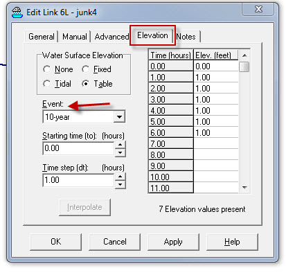
If you have different variable tail water elevations corresponding to different storm events, can you use the same link node in HydroCAD? It seems like you should, as the elevation tab lets you select different events, however when as soon as I define a second event, it overwrites the first. For instance, I select 2-year event, define the tail water, and hit apply. Go to define a 100-year tail water. The 100-year has now overwritten the previously entered two year. Obviously the work around would be to create a link for each event, but it just seems that you can't use the same link node. Using HydroCAD 10.00-16. Thanks.
 
Replies continue below

Recommended for you

If you use a link to define a manual tailwater elevation, the data is applied to all events. The event selection you refer to applies only to a manual hydrograph entry.

Your best solution is to model the tailwater point within HydroCAD using an appropriate reach or pond, so that you have the correct elevation vs. time for each event. Remember that the elevation is constantly varying throughout the storm, so entering a single (fixed) tailwater will rarely produce an accurate model.


Peter Smart
HydroCAD Software
 
This is what I was referring to in the link tab. You can't use this to define elevations for different events without the using a hydrograph?

HydroCAD_czbj6x.jpg
 
That option allows the tailwater to be applied to a specific event. If you specify the event, you can only define the elevation for that ONE event. A link cannot be used to specify a different elevation for each event. To do that you need to model that point in the system so that HydroCAD can automatically calculate the tailwater.

Peter Smart
HydroCAD Software
 
Peter-

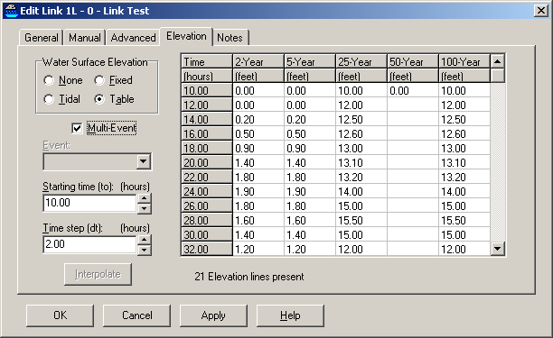
It appears this would be a great "wish list" item: the ability to have a different tailwater curve for each storm event in a single link.
 
Yup, it's on the wish-list.

However, I would advise caution when using a manual tailwater. For correct results, you need a complete table of elevation vs. time, and not just a fixed elevation. Using a fixed elevation (such as the maximum for each event) will generally cause the site discharge to be too low before and after the time of peak tailwater. A fixed tailwater is only appropriate when the receiving water body is stable during the entire duration of your model, otherwise you need to include the receiving body in your model in order to calculate an accurate tailwater elevation vs. time.

Peter Smart
HydroCAD Software
 
While that's absolutely true, Peter, a lot of times we're stuck with a fixed tailwater elevation for a pond, that we're required to take into account. Most commonly, when a pond discharges to a floodplain and the HEC-RAS model for the floodplain is steady state. Steady state models are pretty much the norm as far as I've seen. It's common for me to have a list of relevant flood elevations from a steady state HEC-RAS model for different event storms, but no hydrograph, and no good way to generate one since the drainage area is beyond the scope of TR-20.

Hydrology, Drainage Analysis, Flood Studies, and Complex Stormwater Litigation for Atlanta and the South East -
 
beej67 - I completely understand. I just want everyone to realize the consequences of using a fixed TW if it's not actually fixed throughout the typical 24-hour storm duration.

Peter Smart
HydroCAD Software
 
That's why I would love to be able to put in a full time-stage curve that is linked to each storm event rather than have a fixed tailwater or having to have multiple files to cover the curves for each storm event.
 
A third work-around, Terry, would be to copy/paste the nodes in the model side by side and fix the routing arrows. They would all be in the same model, but you'd have to look at different nodes for different return periods. Some of the summary tables would look a little goofy, in that they'd be double counting areas, but the hydraulic results would be good. I often do this with pre and post development detention pond models, so I can easily compare data between the two models.

Hydrology, Drainage Analysis, Flood Studies, and Complex Stormwater Litigation for Atlanta and the South East -
 
beej67,

Yes, I do the same as a work-around. It is just more cumbersome and can be prone to human error (forgetting to switch the routing), and, as you stated, can look peculiar in reports for reviewers.
 
Status
Not open for further replies.

Part and Inventory Search

Sponsor