Continue to Site

Eng-Tips is the largest engineering community on the Internet

Intelligent Work Forums for Engineering Professionals

  • Congratulations pierreick on being selected by the Eng-Tips community for having the most helpful posts in the forums last week. Way to Go!

3-Second Gust, Maximum Sustained Wind Speed Definitions. 1

Status
Not open for further replies.

Ron247

Structural
Jan 18, 2019
1,052
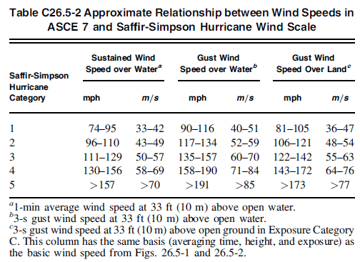
I am trying to bridge the gap between structural design wind terminology and weather terminology. I am not sure if they use the same terms differently. I have asked many others in both engineering and weather but seem to get conflicting definitions.

In structural design, we use a 3-second gust wind speed.
[ol 1]
[li]Is that the average of all readings taken over 3 seconds?[/li]
[li]Is it the highest value over 3 seconds?[/li]
[li]Is it the lowest value over 3 seconds?[/li]
[li]Is there some other definition?[/li]
[/ol]

In weather, they reference a 3-second gust.
[ol A]
[li]Is it the same definition as structural design?[/li]
[li]If not, which of the 4 options is it?[/li]
[li]I am told it is the maximum.[/li]
[/ol]

In weather (hurricane), they reference a maximum sustained wind speed (over 1 minute)
[ol i]
[li]Is that the average? (I am told it is the average)[/li]
[li]Is it the maximum?[/li]
[li]Is it the minimum?[/li]
[/ol]


For structural design, which 3-second gust do they use to construct our maps? Do they perpetually record this or use what came from weather data? Basically, how is this info used to make our wind maps?

 
Replies continue below

Recommended for you

As I understand it...

Readings are based on measurements taken 10m above ground level, usually at an airport. That's a big reason all our charts and equations are calibrated for 30ft and exposure C.

A 3-second gust is the average wind speed for the 3 seconds. This should be the same for both structural purposes and meteorological reporting.

Yes, hurricane reporting is the average over 1-minute. Regular day to day (wind events that aren't hurricanes but can still hit 50 or 60mph winds) are 2-minute averages.

If you ever want to "convert" between wind speeds, you'll want the Durst Curve. (You can't really convert...it's just a statistical comparison that's reasonably accurate.)

Your last question is a complicated one. I'll start with my own question: have you read ASCE 7's commentary in chapters 26-30? If not, start there.
 
Thanks phanEng.

I have not read the commentary yet; so I will as advised.

I think a lot of the confusion is the way they name something. I would call maximum sustained, "average sustained 1 minute wind". Name is a little long but not as confusing.

On the 3-second gust, I have a company that provides a weather related service tell me it is the max wind but, I had another company that provides a weather related service tell me it is the lowest wind speed in the 3 seconds and that you are indicating the wind was "At Least" this strong for 3 consecutive seconds. So, as I said, conflicting answers.
 
3 seconds is the typical time frame or resolution that anemometers use for determining the wind speed.

Here is a short explanation on how the typical anemometer works from this site:
The most common type of anemometer has three or four cups attached to horizontal arms. The arms are attached to a vertical rod. As the wind blows, the cups rotate, making the rod spin. The stronger the wind blows, the faster the rod spins. The anemometer counts the number of rotations, or turns, which is used to calculate wind speed. Because wind speeds are not consistent—there are gusts and lulls—wind speed is usually averaged over a short period of time.

So, as phamENG stated, this makes it the average wind speed over the 3 seconds, but, for most instruments this is also the smallest resolution that it can read so it wouldn't be able to give you a faster "instantaneous" wind speed. - So it could also be considered the fastest measured. The maps we use for structural design and the wind speeds reported by the meteorologist are in deed the same wind speeds (3-second gust).

And phamENG is right, the ASCE 7 commentary has a lot of great information in it for getting a better understanding of all of this.
 
The science geek in me wants to agree on the name, but while it would be less confusing to those of us who need to work with the information in a professional capacity it would probably make Joe Schmoe's brain explode when all he wanted was to see the radar at 7 after. After all, most weather reporting and weather products are intended for consumption by the masses, and they don't particularly care about the accuracy - they just want to know if it's safe to carry an umbrella, or take a boat out, or whatever people use wind reports for (I've never found typical meteorological wind reports useful - when I was flying I used FAA reports, when I take a sailboat out I get NOAA buoy data, etc.).

I had to do a wind write up recently to explain it to an owner. I used serviceability, since anything beyond the serviceability limit and they probably shouldn't be in the building, they should be a state or two away. It was actually a critique of a poorly considered PEMB design they wanted me to design a foundation for. Using the Durst Curve, reported wind speeds of about 60mph as reported on the news will result in a 3-second gust speed of 76mph - which is the 10 year MRI wind speed for much of the US according to the commentary in ASCE 7-10. I had to explain to them that a properly designed building (H/400-H/600) with inter-story drifts limited to about 0.4" would likely show distress and cracking in the drywall at that 60mph reported wind speed. The PEMB designer had used H/60...

 
I just talked to someone who is the "go-to" guy at a weather related business. What he told me makes sense to me and fills in the blanks.

[ol 1]
[li]Wind is reported "hourly".[/li]
[li]For maximum sustained wind for the hour, they take sixty 1-minute intervals. Each of those 1-minute intervals has the recorded wind speeds averaged. From those 60 values, they choose the "highest average" and report it for the hour. In other words, during the last hour, it is the maximum wind that was sustained for a minute.[/li]
[li]For the 3-second gust, it is done the same. Average the readings of each 3-second interval. Report the highest of the various 3-second intervals for that hour.[/li]
[/ol]

To me that explains the confusion I had.
 
ASCE 7 3-sec gust is the highest sustained gust in a 3-sec period measured at 10m. So that would be the maximum gust.
Not sure how your local weather channel uses the term 3-sec gust.
Hurricane wind speed is an average measured over a 1-min period at 10m.

I don't know how reliable your local weather channel will be in reporting wind speeds. ASCE 7 does however address Hurricane wind speeds as reported by NHC and an approximate relationship to the standard ASCE 7 3-sec gust wind speed. I have found that you can "ballpark" the 3-sec gust over land by multiplying the 1-min average hurricane wind speed by 1.110. I would think that most weather channels are relying on the reporting by the NHC, so any hurricane wind speeds reported should match those listed on the NHC.

ASCE 7-16 Section C26.5-1:

Correlation of Basic Wind Speed Map with the Saffir-
Simpson Hurricane Wind Scale
. Hurricane intensities are
reported by the National Hurricane Center (NHC) according to
the Saffir-Simpson Hurricane Wind Scale (NHC 2015), shown in
Table C26.5-1. This scale has found broad usage by hurricane
forecasters and local and federal agencies responsible for shortrange
evacuation of residents during hurricane alerts, as well as
long-range disaster planners and the news media. The scale
contains five categories of hurricanes and distinguishes them
based on wind speed intensity.
The wind speeds used in the Saffir-Simpson Hurricane Wind
Scale are defined in terms of a sustained wind speed with a 1-min
averaging time at 33 ft (10 m) over open water. The ASCE 7
standard by comparison uses a 3-s gust speed at 33 ft (10 m)
above ground in Exposure C (defined as the basic wind speed,
and shown in the wind speed map, Figs. 26.5-1 and 26.5-2). The
sustained wind speed over water in Table C26.5-2 cannot be
converted to a peak gust wind speed using the Durst curve of
Fig. C26.5-1, which is only valid for wind blowing over open
terrain (Exposure C). An approximate relationship between
the wind speeds in ASCE 7 and the Saffir-Simpson scale, based
on recent data which indicate that the sea surface roughness
remains approximately constant for mean hourly speeds in
excess of 67 mi∕h (30 m∕s), is shown in Table C26.5-2. The
table provides the sustained wind speeds of the Saffir-Simpson
Hurricane Wind Scale over water, equivalent-intensity gust wind
speeds over water, and equivalent-intensity gust wind speeds
over land. For a storm of a given intensity, Table C26.5-2 takes
into consideration both the reduction in wind speed as the storm
moves from over water to over land because of changes in
surface roughness, and the change in the gust factor as the storm
moves from over water to over land (Vickery et al 2009a; Simiu
et al. 2007).

Table C26.5-2:
2021-10-19_16_30_11-Window_xxpvys.png
 
If the 3-second is the "highest sustained" wind speed, then that sounds like the minimum recorded wind speed over a 3 second interval since it must be "sustained". I assume sustained means it was present at that magnitude for the entire 3-seconds.

It sounds like the 1-minute definition is close since it is averaged over a minute. But it sounds like there is a difference in the 3-second definition. Taking the highest average over 3-seconds is not the same as highest or lowest over a 3-second interval.
 
Status
Not open for further replies.

Part and Inventory Search

Sponsor