Eng-Tips is the largest engineering community on the Internet

Intelligent Work Forums for Engineering Professionals

Entergy New Orleans Transmission Tower Collapse and Resulting Blackout 6

Status
Not open for further replies.

Mbrooke

Electrical
Nov 12, 2012
2,546
0
0
US
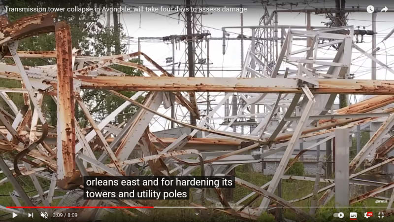
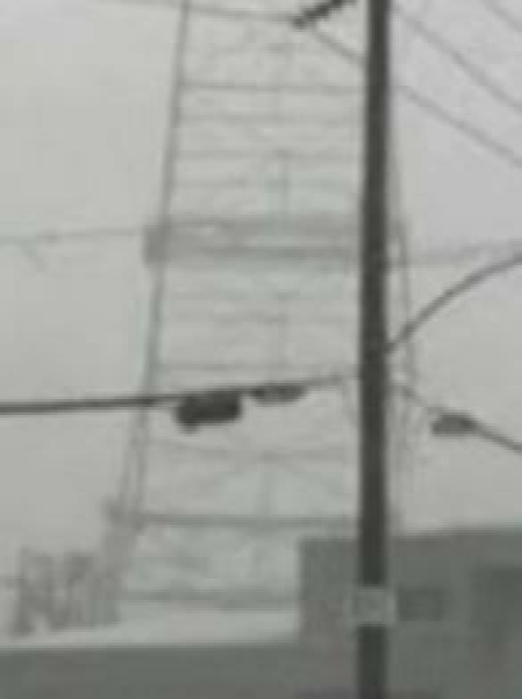
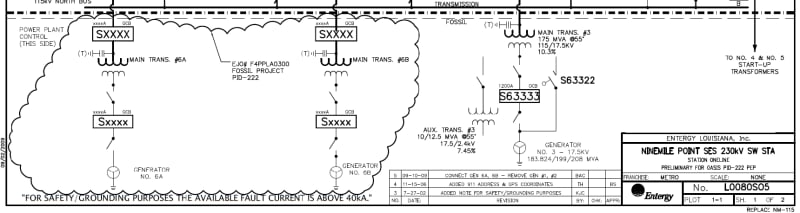
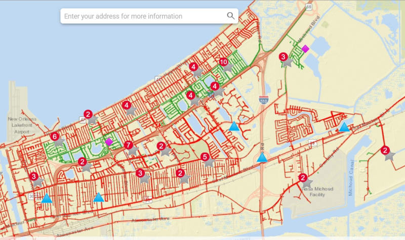
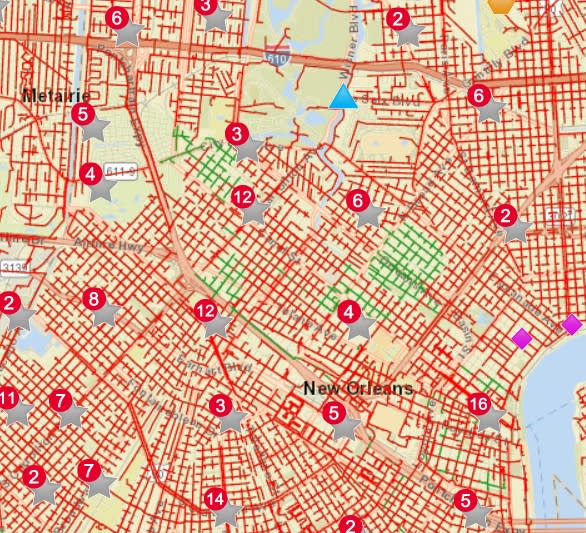
A major transmission tower structure appears to have collapsed into the Mississippi river blacking out all of New Orleans/Orleans Parish:


Reports indicate this to have been a vital power path-


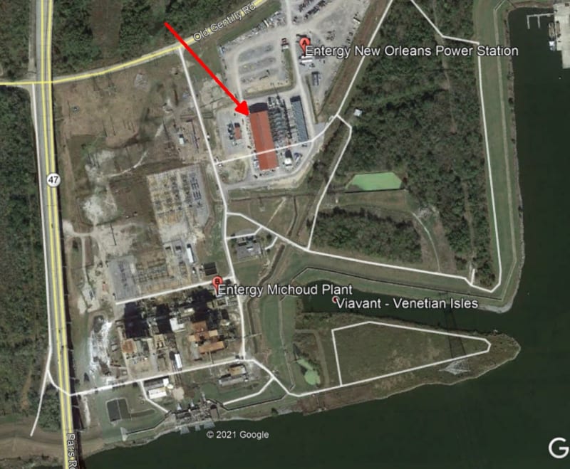
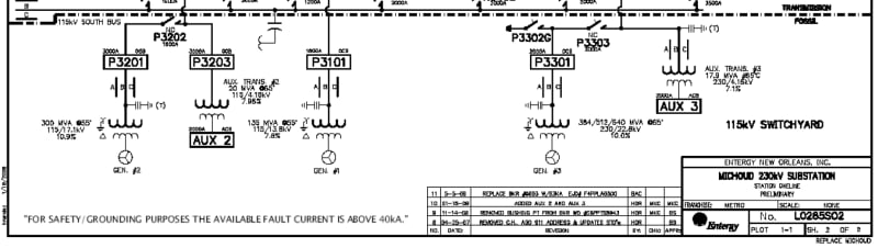
A statement from Entergy says they lost 8 transmission lines which resulted in an energy imbalance causing local generation to trip off line:


Any more info welcome, as well as thoughts on what may have gone wrong and how to prevent this in the future.

As of right now I scouring the net for any more updates or information.

Edit: I am now hearing that possibly all generating stations on South East Louisiana have come off line. No power generation in that entire portion of the state.
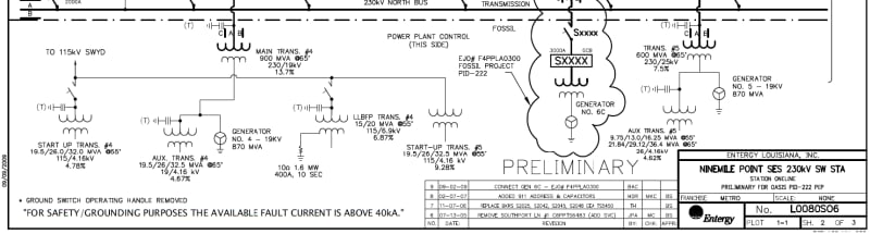
 
Replies continue below

Recommended for you

Anyone have a primer or care to share the challenges associated with UG transmission? I presume heat for one, and insulation for another.

What size/sort of conduit is required for a line of the magnitude that was crossing the river? What’s the diameter of the conductor even? I have no idea.

My simple mind just sees it as needing to drag some thick-walled HDPE into the ground using horizontal-directional-drilling with vaults where the towers used to stand. Which I’m sure is an oversimplification. But how?
 
Spartan5 I would say you are correct on both heat/insulation. Don't forget about cost though. The rule of thumb (which will vary quite a bit based on actual conditions) number I've always heard is that underground is about 10 times more expensive per mile than overhead lines.
 
Does anyone have any info on the other 7 lines, where they are and what their voltage was? I'm seeing both 115 and 230kv lines into New Orleans.
 
Alistair-That is a cool link.

Spartan5-Perhaps either four or eight 12" conduits for each circuit. Many UG projects include an installed spare conductor.

Heat is a huge factor. The conductor needs to be far enough underground to avoid damage from dredging, river bed erosion, and ship anchors. Unfortunately, increased burial depth increases the thermal resistance. As an example of the huge increase in cable sizes needed to for equivalent capacity, I a chunk of underground 3500 kcmil copper that is rated 200 amps less than the adjacent spans of overhead 1272 aluminum conductor. Sometimes in order to match the ampacity of larger overhead wires or bundled conductors, each circuit would need parallel set of cables.
 
Some underground circuits need to circulate coolant through the cable. This brings along the problem of coolant leaks (oil spills usually).

Dominion Power evaluated putting a 2000MW bulk powerline across or under the James River at Skiffs Creek, and came to the same conclusion that the National Grid paper (Alistar's post) came to. Read about it here:Surry-Skiffes Creek-Whealton Aerial Transmission Line.

Oodly after the transmission line was placed into service court action called the permit into question due to some steps missed by the regulator. It is unknown when the permits will be resolved, but we have lights.
 
Btw national grid has loads of interesting stuff for multi disciplinary flavours.

They have been running PhD on heaps of subjects for years.

I helped one lad out with getting ansys to butcher electromagnetics 30 years ago. Which was a bit of a mind screw for a mechanical.
 
I think we can see the tower failing in this photo. Something doesn't look right at the bottom. Perhaps a twist is underway?


Failing_tower_fvrdqv.jpg


Keith Cress
kcress -
 
At 150 mi/hr winds, I can see the wind exciting resonance in the tower or the connected cables. Those additional loads are difficult to quantify. The wind design (ASCE-7 risk category III) is 153 mph.
[URL unfurl="true" said:
https://asce7hazardtool.online/[/URL]]Value provided is 3-second gust wind speeds at 33 ft above ground for Exposure C Category

The 100 year MRI value for this location is 119 mi/hr.

Hazard Category IV only takes the 3 second gust to 158 mi/hr.

A requirement to resist rotational winds (tornado crossing the center line of the tower) is not discussed in the standard, but is possible to encounter. Rotational winds at the top of the tower might not be visible from the ground.

While the tower did collapse, it did - at least for a time withstand extraordinary conditions.
 
Alright, it looks like the were able to blackstart the East New Orleans generating station (Michoud)? and restore a few customers.

This is one the reasons I was asking about Islanded systems a while back. I think this is the only practical way during such widespread damage to and around a load pocket New Orleans.


The solutions include:

Restoration of certain critical transmission lines that tie the Greater New Orleans region to the larger electric grid. Entergy calls this the preferred solution.
Creating an “island” that would temporarily isolate the Greater New Orleans region from the larger electric grid. The standalone grid will operate on a limited basis supplied by local generation from the New Orleans Power Station in Eastern New Orleans and Ninemile 6 in Bridge City.

Entergy says New Orleans Power Station and Ninemile Power Station are valuable to providing power to customers.
 
Looks like the plant that did is a new gas plant:


Clipboard01_qwdghj.jpg


Looking at old public docs it appears like Michoud (shown just to the South) has 3 GSUs rated 300MVA, 135MVA and 640MVA.

Clipboard02_zsgl2g.jpg


Nine Mile has at least one 208MVA and two 870MVA rated generators.


Clipboard03_ozg6w1.jpg


Clipboard04_g3olab.jpg


This does not count new generator add-on. So we are looking at least 2,500MW of power right there, taking into account additions and new generation we are looking at upwards of 4,000 or more MW of power. A strong Island is diffidently doable.

This is why I think local generation with at least some black-start is so important. he 115 and 230kv lines going through NOLA have less exposure relative to longer lines outside the city and being in sidewalk/roadway easements means rapid restoration options at first thought.
 
Looks like it worked. Outage map is now showing some green in East and Central New Orleans:

Clipboard05_ecg6xi.jpg


Clipboard06_l0plnd.jpg


I'm guessing Derbigny and Curran Substations were energized with the 230 kv lines out of Michoud.
 
As a Hurricane Ida survivor, I have been living the problems with the electrical system in southeast Louisiana.

Eeyore said:
along the aptly named Powerline Drive
I think you mean Power Blvd, but ok.

vmrjr24 said:
underground
Some other distribution lines were tunneled under the Mississippi River a mile or so downriver of the French Quarter about a decade ago because when they were overhead, they were a limiting factor on the size of cruise ships that could dock in the city. The 10x factor is good to know.

Mbrooke said:
Could age have weakened the tower? It survived Katrina.
Hurricane Katrina passed just to the east of the city, so New Orleans and this tower were on the "good side" of the storm.
Hurricane Ida passed just to the west of, and a little closer to, the city, so New Orleans and this tower were on the "bad side", with slightly stronger winds.

Mbrooke said:
Alright, it looks like the were able to blackstart the East New Orleans generating station (Michoud)? and restore a few customers.
They may have used power from the Slidell area to start the NOPS in New Orleans East. There was a lot of talk on about Wednesday or Thursday about bringing power from Slidell, but cagey Entergy was unclear of where it was actually going.

I'm not sure if they even have the capacity to blackstart at NOPS, even though that was part of the design proposed when the plant was presented to a NOLA city council vote. Hearings will be held to get some answers after this state of emergency is over.

Mbrooke said:
Looking at old public docs it appears like Michoud (shown just to the South) has 3 GSUs rated 300MVA, 135MVA and 640MVA.
Not sure what you mean by this, but the Michoud plant was decommissioned in 2016.
 
Mbrooke said:
Outage map is now showing some green in East and Central New Orleans

Turns out the green on the map does not even mean that the households in that area have power. A reporter checked it out.

"Entergy officials confirm inaccuracy of power outage map, cite 'communications issues'
BY MISSY WILKINSON | STAFF WRITER PUBLISHED SEP 2, 2021 AT 10:21 AM | UPDATED SEP 2, 2021 AT 8:38 PM
 
Status
Not open for further replies.
Back
Top