Continue to Site

Eng-Tips is the largest engineering community on the Internet

Intelligent Work Forums for Engineering Professionals

  • Congratulations KootK on being selected by the Eng-Tips community for having the most helpful posts in the forums last week. Way to Go!

Estimating Evaporation from Resevoir 1

Status
Not open for further replies.

Terratek

Geotechnical
Oct 17, 2014
269
I'm helping someone with a feasibility study for a hydro-electric project in east Africa. We need to size a reservoir and dam. I have flow rates for the river we will dam and I think I can get rainfall data easy enough to calculate watershed flow rates. The piece I'm missing is evaporation. It appears the Penman method is a popular choice for estimating evaporation. Is there a more simple, relatively reliable method to estimate evaporation from a water surface?
 
Replies continue below

Recommended for you

Try this
or
As this says, the evaporation rate is often listed by local meteorological stations
or even better
It might be 50 years old, but probably good enough for your basis.

Search "evaporation rate XXXX" where XXXX is your country

Remember - More details = better answers
Also: If you get a response it's polite to respond to it.
 
The project is located in Malawi which has fairly limited historical data and we won't have time or resources to do field testing, so the pan method is out. The Kenya document is very interesting, but Kenya is nearly a thousand miles away, so it may not correlate well. This is all pretty new to me, though, so any information is helpful. Thank you.

It looks like the Thornthwaite method is pretty simple. Does anyone have experience using this method?
 
This really needs to be done using onsite weather and water surface temperature data. Jay Ham developed a test to estimate evaporation based on local climate data using an onsite weather station and water surface temperature using an infrared thermometer. The following link will take you to an abstract discussing the method. If you look hard enough you can probably find his research paper online. Jay Ham is a professor at Colorado State.

 
You would also be amazed at what met data exists even in less developed countries. first search properly then say there is no data rather than assume there isn't. You might need to buy some of the papers / data

see this for instance....


If you have no info, work out a best case ( low wind, high humidty, lower temp) and a worst case and calculate the two. Your reality will be somewhere in the middle taking account of seasons.

Remember - More details = better answers
Also: If you get a response it's polite to respond to it.
 
Thanks LittleInch. Feeling slightly defensive, I did not mean to imply there was no data, just limited data - at least compared to more developed parts of the world. Even getting the survey information for the site topo was more complicated than it would have been in a more developed area. We ended up having a local surveyor shoot some benchmarks and we will provide that data to Airbus who will charge us for access time to a passing satellite which will capture the area. They will calibrate the satellite survey data using the locally surveyed benchmark. Really, pretty cool.

The links you have been VERY helpful. I'm a geotechnical engineer and my water resources expertise is about as broad as what I can remember from mechanics of fluids in school. I've come across a handful of papers and the government provided us with the river flow rates. Since I'm on a steep learning curve here, maybe my use of search key words are poor.
 
since you have no data and are not scoped to go out and collect any, you will need to use the best available. or the best you can estimate. If you cant obtain data, than find an area with similar climate and use that. Of similar importance is topography, soil and land cover data which controls how much runoff makes it to the reservoir.

in general, water balance calculations are notoriously difficult to do with any degree of accuracy, even with good data. so it really does not matter which method you use, your results will be inaccurate. estimating fewer variables may be a better approach. Expect that you will need to do a range of estimates and your margin of error and corresponding uncertainty will be very high. Given the importance of this calculation to the feasibility of a hydro project, I would expect that eventually, you will be in Malawi collecting the necessary data

this is really a task for a hydrologist, hope this will be peer reviewed.
 
Ok,

I'm assuming you know about SRTM - basically Free topography info at 90m centres?

Getting your own bespoke, up to date satellite info is great, but there's an awful lot of free stuff out there which for many purposes is just as good. Google Earth isn't far out. I agree it's really cool, but it's also not cheap.

A decent GIS engineer will easily benchmark your data to local data.

Most reservoirs /dams try to be deeper than wider to reduce evap losses - don't know what your valley or area looks like or how big your hydro project is, but I'm having difficulty believing evaporation is a significant part of the design or issues.

Remember - More details = better answers
Also: If you get a response it's polite to respond to it.
 
We've already paid for the survey data. Google earth is good, but can be off by several meters, so we wanted to tie that down a little better since that will significantly impact earthwork quantities for both the reservoir and other civil site design items that are part of the study (channel to standpipe turbine, roads, accompanying industrial park, etc.).

This is a feasibility study, so our goal is to get to 50 percent construction docs. That will satisfy the grant and will position us to raise funding to actually build the project. We will bring on more highly specialized consultants for tasks that we need help with at that point. My partner recently came back from a 3 week visit to Malawi, so yes, onsite work would certainly be part of final design and construction if we can push it that far.

Depth of the reservoir verses breadth should not be an issue. The topo is very steep so it will be a relatively deep reservoir.

Evaporation may very will be virtually negligible considering the size of the project and the other variable conditions such as river flow rate and rainfall. This is definitely a judgement better made by an engineer who works regularly with water resources. My concern is that there is a 3-4 month rainy season and then virtually no rain for the remainder of the year, although the river will flow throughout the year. Back of the envelope, how big does a reservoir need to be for evaporation to be of significant concern?

It seems that the biggest drawback to over-estimating evaporation would be a larger dam than required. That would increase construction costs. But assuming those could be covered, what other problems could arise from over-estimating evaporation? Having a larger reservoir would be preferable (provided the costs can be justified) as that extra capacity could be used to generate more power or even provide some limited irrigation to the local farmers.
 
50% construction docs at the feasibility level?!! seems a bit optimistic

you have got to look at the entire hydrologic process, in the watershed, river and reservoir. rainfall -> runoff -> infiltration -> evaporation -> transpiration - groudwater flow -> diversions -> spillway flows > flow to penstock. you build the dam and size the spillways to hold as much of the water that flows into it that you can. The dam and spillway will probably be designed to handle the PMF. Unlikely that ET losses would play a role in the height of the embankment. But it might affect your operational freeboard and hydro generation during the dry season. so once the reservoir is full at the end of the rainy season, you have 9 months of steady evaporation and also you are drawing down the reservoir at the same time by running the turbines to power the generators. the power output will steadily decrease during the summer due to declining water levels.

 
My experience comes from design of ponds where you're trying to get the water to evaporate as otherwise it's a bitch to dispose of.

I would be astonished if your yearly evaporation rate exceeded 1.5m. This is based on surface area so if your surface are is at 0.1 of your average depth then your loss of total volume becomes much less.

assuming your dam is full to overflow / spill way level at the end of your rainy period, then you have a relatively straightforward feasibility equation for water in from river minus water to hydro minus the volume 1.5m is for your surface area to work out depth of water after 9 months. Only you know the details as to whether this is a significant extra loss of water or not

Of course your range of estimates includes years when the rains are not as good perhaps or the environmental impact of large mud flats / dead soil at the end of the dry period.


Remember - More details = better answers
Also: If you get a response it's polite to respond to it.
 
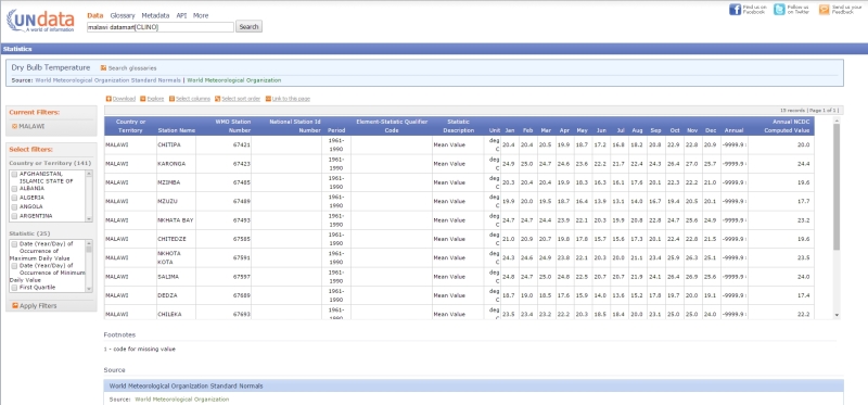
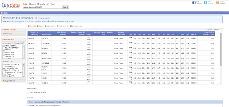
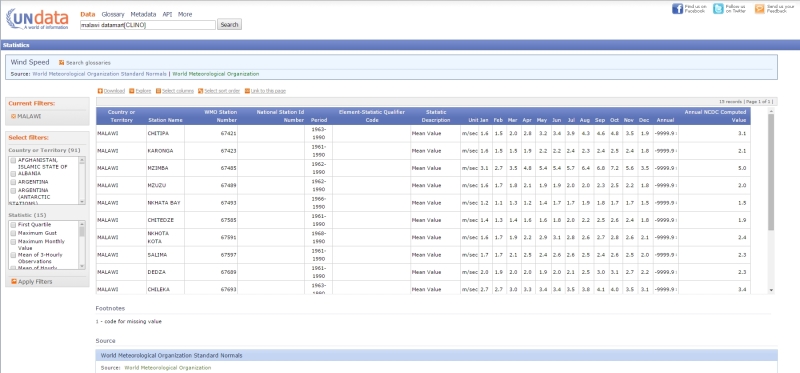
Historical local climate record data is publicly available at the UN and NOAA, which can used to get an general estimate for the exercise you want.
It seems the rainy/wet season lasts somewhere from Nov-Dec to Mar -April depending on the year. So I would expect a typical rainy/wet season to lasts 4 months.
see the links below
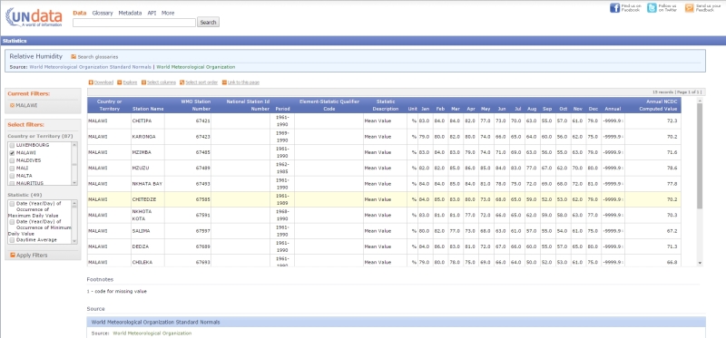
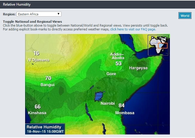
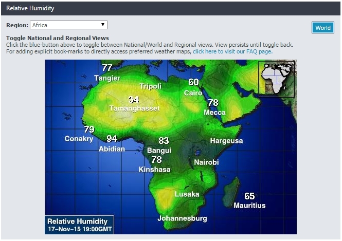
relative humidity
2015-11-18_12_42_27-UNdata___record_view___Relative_Humidity_vhmfwu.jpg


2015-11-18_12_51_18-Intellicast_-_Relative_Humidity_in_Eastern_Africa_mzvily.jpg


2015-11-18_08_49_24-Intellicast_-_Relative_Humidity_in_Africa_v9ggoi.jpg


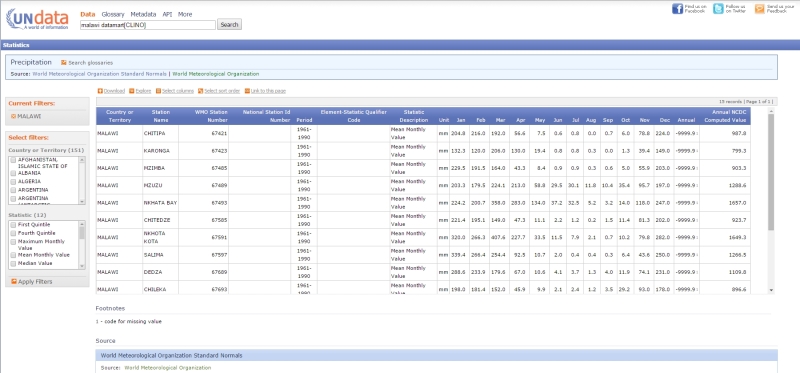
precipitation
2015-11-18_12_40_57-UNdata___record_view___Precipitation_pxosys.jpg


temperature
2015-11-18_12_41_22-UNdata___record_view___Dry_Bulb_Temperature_xiqbsv.jpg


2015-11-18_12_40_18-UNdata___record_view___Minimum_Dry_Bulb_Temperature_quaksu.jpg


wind
2015-11-18_12_41_43-UNdata___record_view___Wind_Speed_vwzat9.jpg


UN Data

NOAA Climate
[URL unfurl="true"]http://www.ncdc.noaa.gov/cdo-web/[/url]
 

CVG,

Are 50 percent construction docs unrealistic with 4 people (2 full time and 2 part time) working on the project over the course of 7 to 8 months? I wouldn't know. I'm not leading the project and have never worked on something like this before. I'm just a helper. The power generation will not decrease with time as long as we maintain above a certain level because we are not placing the turbine in the dam. There will actually be a channel parallel to the river AFTER the dam that feeds a small secondary reservoir above a penstock turbine and the water will discharge back into the river at that point. So as long as the water level is above the channel level, the power generation can be consistent. The power will actually very with a needle valve at the turbine upon demand, but that's another topic that I know even less about.

I understand from your post that need to consider watershed, river and reservoir. rainfall -> runoff -> infiltration -> evaporation -> transpiration - groudwater flow -> diversions -> spillway flows > flow to penstock.

Since our river flow rates were collected at a point just slightly down stream from the proposed dam location, I think all the watershed, river and rainfall inputs are built into that number, no? The face of the dam would be a new watershed feature, but that should be negligible.

Groundwater flow is something I'm also concerned about, but I think that would reach a state of relative equilibrium since the subsurface stratigraphy appears to be of clay and rock (we'll verify). We will definitely need to account for ground water flow through the dam, though. We are actually going to sub the dam design out since even that is more specialized than what I handle on a day to day basis.

Would transpiration be much of a factor?
 
Status
Not open for further replies.

Part and Inventory Search

Sponsor