Continue to Site

Eng-Tips is the largest engineering community on the Internet

Intelligent Work Forums for Engineering Professionals

  • Congratulations KootK on being selected by the Eng-Tips community for having the most helpful posts in the forums last week. Way to Go!

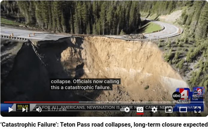
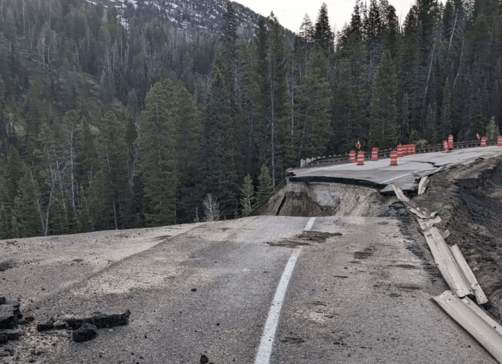
Major Highway Embankment Failure June 8, 2024

Status
Not open for further replies.

FacEngrPE

Mechanical
Feb 9, 2020
1,604
WYDOT shares video of Teton Pass landslide damage]

Commentary from Casey Jones

ITD assists WYDOT as travelers must detour with closure of Teton Pass

IDT said:
drivers should plan an additional 30-75 minutes of travel time between jackson hole and .

Screenshot_from_2024-06-08_20-06-39_hsp6b7.png


Screenshot_from_2024-06-09_17-53-25_jffdar.png
[pre][/pre]
 
Replies continue below

Recommended for you

Probably. Vegetative cover can help with surface erosion, but I think Tug was being facetious.
 
Tug? No way.

I don't think it is an erosion issue.
Slope >>> angle of repose, and is just too fkn huge, wet or dry.
Hard to believe anyone ever thought it was actually a stable slope. Temperature of the earth or asphalt, or rain, had nothing to do with that. No water is going to stay on that slope long enough to seep in.

The guardrail is at the top. Most of the blown out material can't be seen. It's way down the slope, not even in the picture.


--Einstein gave the same test to students every year. When asked why he would do something like that, "Because the answers had changed."
 
1503-44 said:
No water is going to stay on that slope long enough to seep in.

It's a mountain pass. Of course, the ground will become saturated during the spring melt, which is typically when most of the landslides in the mountains occur.

1503-44 said:
Hard to believe anyone ever thought it was actually a stable slope.

It sounds like it was relatively stable for a long time. So, if it wasn't water and some change in the slope's geometry from years of erosion, what happened?

Most geotechnical problems revolve around water. If I were to guess, 99.9% of slope failures, specifically slopes that have been around for decades, are from water-related problems.

By the way, the Angle of repose of soil varies a lot. It can be 34 degrees, which is roughly a 1.5H:1V slope, or 20 degrees (2.7H:1V). That photo posted earlier shows 1.5H:1V at the failure, which is common for slopes with rip rap protection in many geologic areas. Some LiDAR data shows it being closer to a 2H:1V, which is very typical for a vegetated slope.

There were obvious signs of a slow, progressive failure. In my experience, many mountain highways are built on the "good enough for now" and "we'll deal with it later" ethos. For great examples, refer to I-70 through the Colorado Rockies and the "million-dollar highway"/US-550 in Ouray/Silverton, Colorado. I've encountered boulders the size of buses sitting in the middle of I-70 during the spring melt.
 
Also, I think the brought new soil in and placed it on top of the collapsed soil so the footprint should be much wider.
 
True, a little bit of freezing water can do a lot of damage as it thaws.

The photos look to have much more slope.

--Einstein gave the same test to students every year. When asked why he would do something like that, "Because the answers had changed."
 
A little bit. Enough to the water supply for large regions of the United States.
 
I try to avoid watching that guy's videos. He plays Monday morning quarterback analysis. He picks on people for misspeaking in a public setting. Still, he then continues with his video, spouting half-baked ideas and himself misspeaking when he can edit the video/statements. My recommendation for him is to have an expert guest who does the type of work being analyzed and interview them regarding the situation and industry norms. Not pretend that he knows it all or even knows enough to post a video and ask for money through Patreon.

I give Casy credit for digging up details of the situation, but I give him zero credit for discussing geotechnical details. He botched the commentary on the soil nail wall in Canada. I watched that video you posted, and my opinion hasn't changed. I hope that his videos improve as time goes on.
 
MTNClimber, knowing what WYDOT has presented would you have signed off on the repair?
 
I don't think we have enough information to say if the temporary repair is adequate. Do we have borings, lab testing, and the geometry of the temporary slope? A "factor of safety" of 1.2 for a slope analyzed in a 2D limit equilibrium analysis could actually be an FOS of 1.01, 1.2, or 1.5 in real life, depending on how conservative or aggressive the soil parameters used. We don't have all the information to provide meaningful comment on their temporary solution.

That said, if the temporary slope is in good condition now, and they plan on having the permanent solution in place before the snow starts falling again, I'm hopeful that they will be fine.
 
Maybe. Or maybe it’s based on decades of experience in the WY Rockies.
 
MTNClimber (Geotechnical) 1 Jul 24 21:03 said:
There were obvious signs of a slow, progressive failure.

Unless I misunderstood, the reports were that the initiation was more recent (as in the past few years) and that the progression was accelerating. Obviously the underlying issues were misunderstood and authorities failed to appreciate the significance of the acceleration, even in the week prior to the failure.

MTNClimber (Geotechnical) 2 Jul 24 13:58 said:
commentary on the soil nail wall in ...

We do some good stuff in Canada and sometimes not. Some jurisdictions may have deeper issues to contend with ... (say no more)

In the bigger picture, is the talent pool deep or broad enough to contend with the myriad of issues that press on the community in our fast paced world?
 
It will be interesting to see how many outfits, if any, respond to WYDOT's RFP, what they propose, and how much it will cost.

MTNClimber, you compared the Million Dollar Highway to this situation. Do you think that's fair? The MDH was carved out of fairly stable rock, and once carried mining trains. At least that is my recollection. Here we have a large man made embankment comprised entirely of fill.

Also, your reference about boulders falling from above and coming to rest in the roadway is interesting. We've all seen them. I'm not trying to be snarky, but it's kind of unrelated to this situation.

Do you think any special measures will be taken to drain water from the embankment? Or will they just rely on grading and surface runoff as was done in the past? In the last Casey video he may have mentioned WYDOT plans for a culvert, but I could be mistaken.
 
Sym P. le said:
Unless I misunderstood, the reports were that the initiation was more recent (as in the past few years) and that the progression was accelerating. Obviously the underlying issues were misunderstood and authorities failed to appreciate the significance of the acceleration, even in the week prior to the failure.

I'm right there with you. WYDOT should have done more to investigate what was going on, and luckily, the mudslide closed the pass, avoiding a true tragedy.

GreenLama said:
MTNClimber, you compared the Million Dollar Highway to this situation. Do you think that's fair? The MDH was carved out of fairly stable rock, and once carried mining trains. At least that is my recollection. Here we have a large man made embankment comprised entirely of fill.

Also, your reference about boulders falling from above and coming to rest in the roadway is interesting. We've all seen them. I'm not trying to be snarky, but it's kind of unrelated to this situation.

I do think it's fair to compare man-made highway mountain passes with each other, especially when talking about the required maintenance involved. These are relatively active geologic areas. Debris flow, slope instabilities, avalanches, and rockfalls are just the start of the issues they contend with. It costs a lot to construct them and maintain them. I've driven them enough to realize there is a limit of what a DOT can do. At some point, they adopt a mentality that resolves them to, "We can't do more with what we currently have". I'm not saying it's right, I'm just saying that's what it appears to be based on my experiences.

MDH and I-70 through the Rockies are not stable in all areas and require constant maintenance and mitigation efforts by CDOT.

It also relates to the situation in that people here are saying, "I can't believe they ever thought that the slope was stable." Well, it was for a very long time, which is better than some mountain passes. I would also invite those to drive the mountain passes that I've driven, and they will be filled with examples of "I can't believe they think this will work long term." After years of living in the mountains, I learned that they don't. It's just the best they could do at the time with what they had. Drive it at your own risk. Not saying that it's right. It's just what it is.

GreenLama said:
Do you think any special measures will be taken to drain water from the embankment? Or will they just rely on grading and surface runoff as was done in the past? In the last Casey video he may have mentioned WYDOT plans for a culvert, but I could be mistaken.

I hope so! To avoid this issue again, they should make sure that the foundation soils for the embankment are strong and well drained. I'm not sure if a culvert is the answer or if putting in horizontal drains would work. It's tough to tell with the limited information we have. Ground improvement could also consist of aggregate piers which would help reduce the chance of porewater pressure building up in the clay layer, if that exists. I don't have the borings and Casey sounded like that was an assumption on his part.
 
Status
Not open for further replies.

Part and Inventory Search

Sponsor