Navigation
Install the app
How to install the app on iOS
Follow along with the video below to see how to install our site as a web app on your home screen.
Note: This feature may not be available in some browsers.
More options
Style variation
-
Congratulations cowski on being selected by the Eng-Tips community for having the most helpful posts in the forums last week. Way to Go!
You are using an out of date browser. It may not display this or other websites correctly.
You should upgrade or use an alternative browser.
You should upgrade or use an alternative browser.
Minimum Depth of Cover for Pipelines
- Thread starter Khalid88
- Start date
- Status
- Not open for further replies.
LittleInch
Petroleum
Errr, why can't you look yourself? I'm sure anyone interested in pipelines has access to the latest copy of these codes....
You only need extra weight where the pipeline can float.
Remember - More details = better answers
Also: If you get a response it's polite to respond to it.
You only need extra weight where the pipeline can float.
Remember - More details = better answers
Also: If you get a response it's polite to respond to it.
LittleInch makes a valid point.
These are MINIMUMS. Greater depth is required when necessary to provide adequate protection.
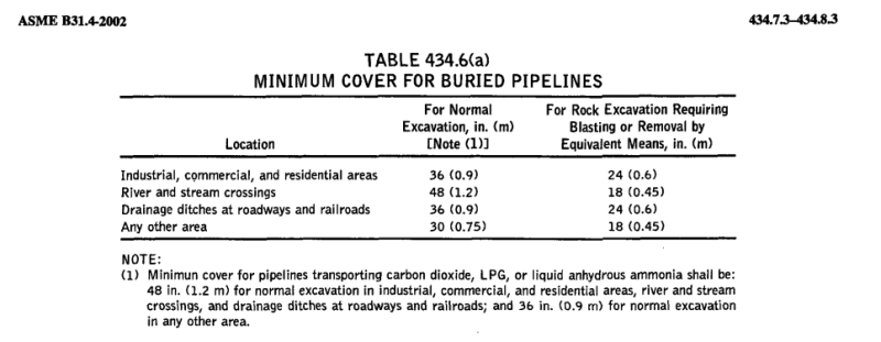
36" clear cover in normal areas
48" clear cover in agricultural areas
48" clear below river bed
Not in codes
36" clear below mud line in USA offshore water depths to 200ft
10ft clear in navigation canals
15 ft in anchorage areas (but you don't want to go there)
10ft Surf zones
You can have a look at PIPELINE SCREW ANCHORS
LittleInch
Petroleum
You don't need 4ft / 1.2m.
READ THE CODE
Remember - More details = better answers
Also: If you get a response it's polite to respond to it.
READ THE CODE
Remember - More details = better answers
Also: If you get a response it's polite to respond to it.
Coming right back at you, but you may be right. It could depend on which editions we're talking about.
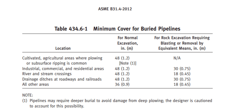
Quoting from 2012 editions B31.4 & 8
(sorry I don't have a newer ones at hand right now as they are not legal editions in the USA. Even the 2012 versions are not USA legal.
You might be so kind as to post newer version's references.)
LittleInch, you are right. I don't think I have ever looked at this 2012 ecition of B31.8
It seems that they have reduced all the cover requirements. Did they do the same in newer than 2012 editions of B31.4?
You hardly need 36" anymore.
Guess that tells us why these versions still aren't legal requirements in the USA.
B31.8 also a 2012 version
NOTE CFRs, the legal requirement in the USA, do not have the same cover depths listed above.
Quoting from 2012 editions B31.4 & 8
(sorry I don't have a newer ones at hand right now as they are not legal editions in the USA. Even the 2012 versions are not USA legal.
You might be so kind as to post newer version's references.)
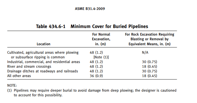
Table 434.6-1 Minimum Cover for Buried Pipelines
Cultivated, agricultural areas where plowing or subsurface ripping is common [Note (1)] 48 (1.2m)
Industrial, commercial, and residential areas 48 (1.2m)
River and stream crossings 48 (1.2m)
Drainage ditches at roadways and railroads 48 (1.2m)
All other areas 36 (0.9m)
NOTE:
(1) Pipelines may require deeper burial to avoid damage from deep plowing; the designer is cautioned
to account for this possibility
LittleInch, you are right. I don't think I have ever looked at this 2012 ecition of B31.8
It seems that they have reduced all the cover requirements. Did they do the same in newer than 2012 editions of B31.4?
You hardly need 36" anymore.
Guess that tells us why these versions still aren't legal requirements in the USA.
B31.8 also a 2012 version
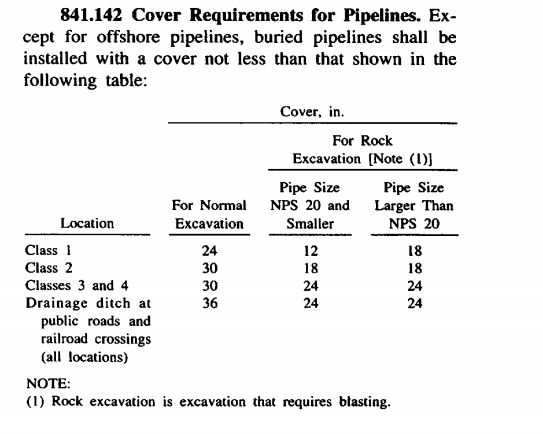
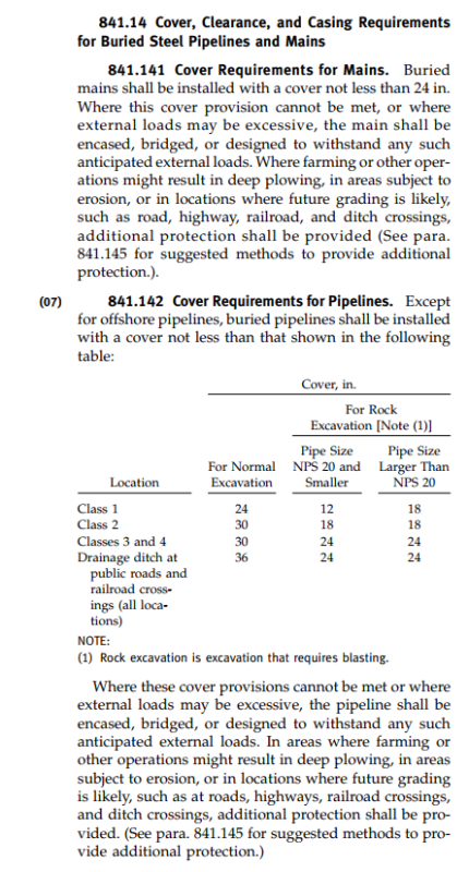
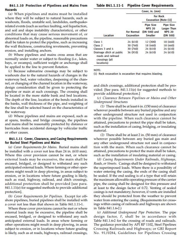
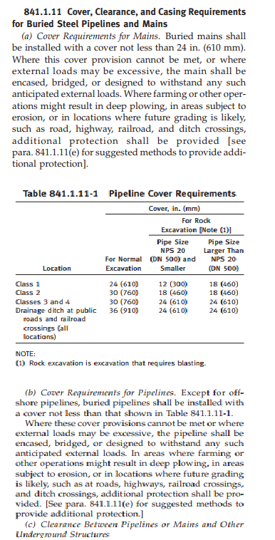
Location Normal
Class 1 24 (610)
Class 2 30 (760)
Classes 3 and 4 30
Drainage ditch at public roads and railroad crossings (all locations) 36"
NOTE CFRs, the legal requirement in the USA, do not have the same cover depths listed above.
Better I post links that show the CFR details,
Natural and Other Gas Pipelines CFR 49-192
Cover 192.327 B31.8 (Ref to 2007 edition)
Cover Over Buried [Hazardous Liquid] Pipelines
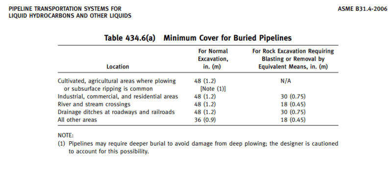
Ref to B31.4 (2006 Edition)
Natural and Other Gas Pipelines CFR 49-192
Cover 192.327 B31.8 (Ref to 2007 edition)
Cover Over Buried [Hazardous Liquid] Pipelines
Ref to B31.4 (2006 Edition)
- Thread starter
- #9
Thanks everyone for the help. I do have the codes and I read them too. But the situation is quite different.
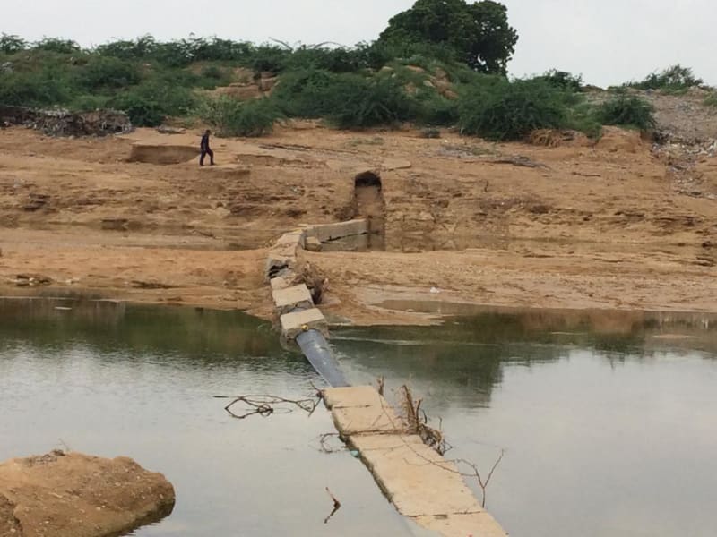
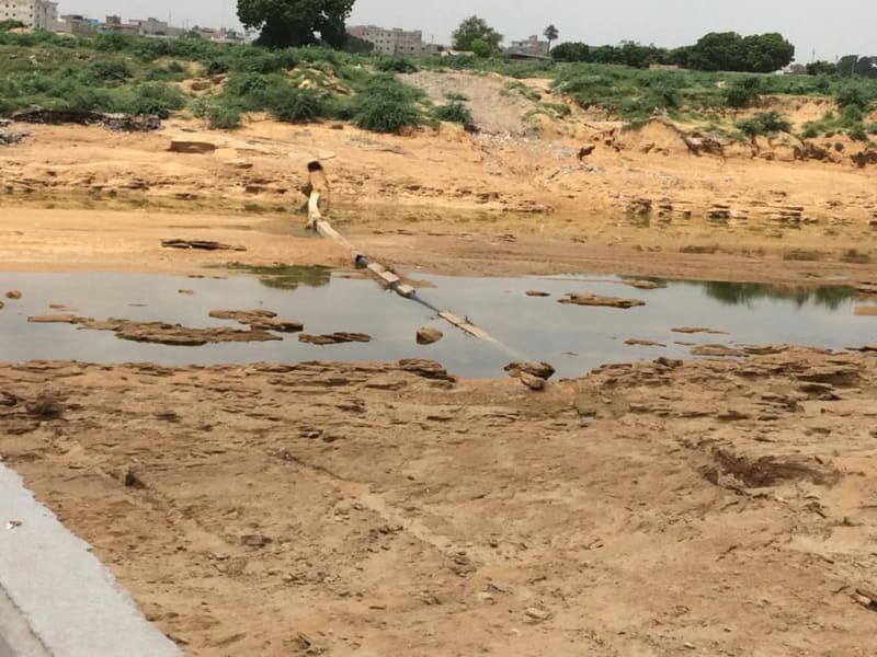
Due to recent torrential rains in the city, one of the Client's pipeline has come up to the surface, meaning depth of cover has been washed away.
I was asking for the help in this regard.
Due to recent torrential rains in the city, one of the Client's pipeline has come up to the surface, meaning depth of cover has been washed away.
I was asking for the help in this regard.
- Thread starter
- #11
LittleInch
Petroleum
A lot of unknowns. so you need to give us much more information if you want some help.
Is the soil now more like a permanent swamp or has it dried out again?
Lowering pipeline in service is difficult and can result in rupture very easily. Adding depth of cover is one option, but then creates a hump and can lead to more upheaval buckling.
Remember - More details = better answers
Also: If you get a response it's polite to respond to it.
LittleInch
Petroleum
So you need to replace it and prevent it from washing away again.
Rip rap, concrete mattresses, gabion walls, digging new flood channels etc
Remember - More details = better answers
Also: If you get a response it's polite to respond to it.
Rip rap, concrete mattresses, gabion walls, digging new flood channels etc
Remember - More details = better answers
Also: If you get a response it's polite to respond to it.
- Thread starter
- #14
LittleInch
Petroleum
Aaah. Now it makes sense.
I think you're into a new river crossing here.
Anything you do to
a) get the line back straight
b) lower it
could easily overstress it and you still won't get it the approx 2m you need below the latest bottom of the river / wadi.
Then you really need some significant protection to prevent it washing it out again. Which is very difficult in that soil.
Remember - More details = better answers
Also: If you get a response it's polite to respond to it.
- Thread starter
- #16
LittleInch
Petroleum
The work you would need to do to stop this just happening again next year are about the same as a new crossing and you would create a bit of a dam across the river.
I know things change over time and the floods are getting worse, but this looks like it was never quite deep enough in the first place.
Just be thankful i didn't break during the flood and don't expect / rely on such good fortune a second time. God / Allah will only smile on you once.
Remember - More details = better answers
Also: If you get a response it's polite to respond to it.
- Thread starter
- #18
Needs to be at least 1.2 meters below the maximum scoured depth. The river bed profile you see there now probably does not reflect max scour depth, as the river has slowed down and deposited all its silt in the stream bed again, above the max scoured elevations. You need some core samples to prove where max scoured depth is now.
LittleInch
Petroleum
More like 2m I think in that sort of soil.
Open cut will be difficult to re-instate to prevent washout.
Remember - More details = better answers
Also: If you get a response it's polite to respond to it.
Open cut will be difficult to re-instate to prevent washout.
Remember - More details = better answers
Also: If you get a response it's polite to respond to it.
- Status
- Not open for further replies.
Similar threads
- Locked
- Question
- Replies
- 5
- Views
- 5K
- Locked
- Question
- Replies
- 12
- Views
- 4K
- Question
- Replies
- 5
- Views
- 4K
- Locked
- Question
- Replies
- 12
- Views
- 5K
- Replies
- 12
- Views
- 9K

