Eng-Tips is the largest engineering community on the Internet

Intelligent Work Forums for Engineering Professionals

  • Congratulations waross on being selected by the Eng-Tips community for having the most helpful posts in the forums last week. Way to Go!

Photogrammetry of interiors 1

Status
Not open for further replies.

milkshakelake

Structural
Jul 15, 2013
1,106
US
I'm looking for an alternative to Matterport. It's a 3D photography solution that allows measurements and walking around. It has been tremendously useful on a few projects for structural inspections (I didn't do it myself, it was provided by clients).

My issue with Matterport is that it's severely limited by subscription fees. The subscription fees have a limit to how many sites I can do. I'm doing like 3-10 sites a week, so the costs will add up really fast if I do 3D photography on all of them. Right now, it's all with traditional 2D photography, but I run into issues with measuring things after the fact, and sometimes missing some shots. The other issue with Matterport is that if I stop paying the subscription, I lose the data. I want to own the data and process it myself.

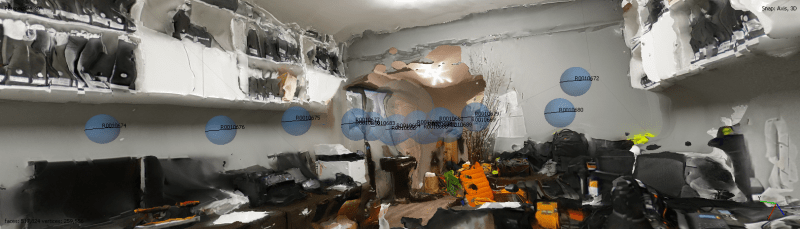
Any alternatives? I was looking at some Leica systems, but they're really expensive and overkill for what I need this for. It's not out of my budget; I'll get it if it does what I need. But it also needs subscriptions for its software, and I really need to start going into a rabbit hole to find a way to use it without subscription. Maybe someone knows of a software I can purchase one time? Agisoft Metashape looks promising enough.

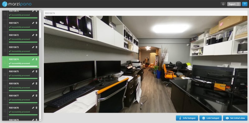
There's also the question of hosting the 3D photos to clients. Let's say I was able to process all the data myself. Is there a way to host it online myself, or it can only be viewed in-office?

I'm a bit lost here. Any advice would help!
 
Replies continue below

Recommended for you

Recap (NON-PRO) is free and can be used by clients. Hosting the data is as easy as using GoogleDrive/DropBox/OneDrive. If you want complete control over the source files then providing clients with the online cloud view should be suitable.

I use the Leica RTC360 and it is an amazing piece of kit. These tools are game changing and they are the way of the future. They just are on the expensive side for individuals or smaller organisations. I haven't used the small Leica items but they look great for sole operators or smaller organisations that don't need the precision of the RTC360 or above.

I can speak highly of Leica and the benefits it can bring. I can't comment on the economics of it in your case however, as you are discovering they aren't cheap.
 
Nice! Is there any other software I need with the Leica kit, or just Recap? And how accurate is it in practice? It's good to know that I can just buy the hardware and use it without worrying about subscriptions and stuff.

Does Recap free edition work for your purposes? Like measuring the size of a steel beam or something. Are there limitations in practice I should be aware of? I'm not deathly opposed to buying a subscription (I prefer not to, but life is life), but I just want to get a clear idea. From the website, it looks like free is quite limited.

Also, does it work with Lidar-based data combined with images, or it's image analysis only?

The Leica is not totally out of my budget; I'd have to see if it works revenue-wise. But it looks like Recap can be used with a variety of cameras, so I could potentially try it out with a cheaper camera and upgrade to the heavy Leica stuff if it makes sense.
 
We use Cupix and a 360 camera. Cupix will create plans if your panos are good enough, but it takes practice. You need a lot of geometry so the software can figure out how to align the panos. We have tried doing exteriors, and it works terrible unless there is a lot of equipment on site. You can find your own Pano software if you want to host it.

I suggest watching Ben Claremont videos for camera recommendations.

The handheld Leica was $75k CAD when I looked. The tripod version was $25k. Neither were in our budget range nor made any sense for our role. This technology has came a long way, but you really need to know what your goal is. Measuring beams for design (say < 1/16" tolerance) is not all that likely unless you are using a Terrestrial scanner.
 
I checked it out. It seems subscription based, which is a long-term problem. I like to own my own data. I'll contact them about pricing anyway.

How dimensionally accurate is it using a 360 camera? I'm not going to be measuring stuff to 1/16" in 3D, but I'd like to know generally if something is an 8" or 10" joist.

Can I download the 3D tour after using it, or do they basically own the data and I have to pay to access it? That's a major problem I have with Matterport.

As far as I have researched, I haven't found a pano software that can take 360 video and make a measurable tour out of it. I'll have to dig around.

Thanks for the channel recommendation!
 
Cupix is far more reasonable unless you want to host a lot of models at one time. I think our subscription is something like $20/mon. If you go over 5 models it jumps up, and the option to create plans costs a few more $$. We do not have the option for the plans right now. We did not find it as useful as we thought, and it really takes skill to get enough panos.

Most of the companies that include the option to simplify the registration process do not let you download the completed model. They make their money by keeping you and your data forever. I looked at software to register the pano's, but I did not find many that took it to the level we would want. Lots had many very good features to make great looking videos, but did not delve into creating plans. Recap registers scan data, but I am not sure how well it works with panos. We use recap for our scanner. Ben has many videos on making professional 360' tours and I believe he covers some of the more popular software options.

We thought the pano's would be nice for clients, but few would take the time to look. As soon as they need to create an account or login, it becomes a problem. If you have more high tech clients it might work better. We gave up.

Hmm, 8" to 10". That will depend a lot on the site. Your site lines for joists are not great and you are bound to have things in the way. Beams/walls/columns... are going to be better. Again, you need geometry for the auto-align to work well. Empty endless white walls are tricky unless there is something in the photo for the software to identify in multiple images. If you are looking for something you can put on a plan I think you will be looking at the Matterport or Leica tripod version. Leica has an accuracy estimate, but I do not recall the value.

Before getting to far into this I suggest you start by buying a $600 - $1,000 camera. Use some of the basic software for a few months and test it out. Honestly, our camera sits on a shelf most of the time.
 
milkshakelake said:
Nice! Is there any other software I need with the Leica kit, or just Recap?
Recap is just the final viewing software. You do need other post processing software with the Leica kit. I believe it comes with it. I have no idea about cost and licensing of it, I'm not paying the bills on the Leica machine nor am I performing the post processing.

I have used the 3D dot viewing and dot plot extensively and done a site scan once. It was pretty easy to do.

milkshakelake said:
And how accurate is it in practice?
As soon as you start stitching scans together (which is necessary) then user error can become involved. So hard to say completely as I think we don't do it as well as we should. It is accurate enough that mechanical drafting is done extensively off it +/-0.5mm is expected locally. Could be +/-5mm depending on the quality of the stitching.

(I can tell how thick a beam's flange is from the scan. If I have two alternatives one beam with a 13mm flange and another with a 11mm flange the scan will reliably identify to me the beam. If it 11mm &12mm I'd want a site measurement.)

milkshakelake said:
It's good to know that I can just buy the hardware and use it without worrying about subscriptions and stuff.
Sorry. I didn't mean to suggest that. I'm not sure what subscription is required.

milkshakelake said:
Does Recap free edition work for your purposes? Like measuring the size of a steel beam or something. Are there limitations in practice I should be aware of? I'm not deathly opposed to buying a subscription (I prefer not to, but life is life), but I just want to get a clear idea. From the website, it looks like free is quite limited.
Unsure, as I only have pro.

milkshakelake said:
Also, does it work with Lidar-based data combined with images, or it's image analysis only?
The RTC360 is primarily Lidar. It overlays images to give the lidar colour and it provides full 3D images from the scan points.
 
Brad805 said:
Most of the companies that include the option to simplify the registration process do not let you download the completed model.

Oof...this one hurts. I'll research software a bit more and see if there's one that lets me process and keep my own data, and use it as I wish. Thanks for the advice, I'll probably start with a cheap one instead of jumping into a Leica. With the cheaper options, will I be able to measure things roughly, like within 2" or so? So I wouldn't be able to tell between an 8" joist or 10", for example, but I could measure that a joist span is roughly 18'-6" and the shear wall next to it is roughly 8'-3" long.


human909 said:
You do need other post processing software with the Leica kit.

That's the part I'm a bit hung up about. I chatted with photogrammetry folks on Reddit and they said that pretty much everything is subscription based, and it drives them crazy. It also gives me a bad feeling about not owning my own data. Anyway, I found one software that seems promising, and I'll report back if it actually works.


human909 said:
Recap is just the final viewing software.

Ah, that's the kicker.
 
milkshakelake said:
It also gives me a bad feeling about not owning my own data.
With the system we use we own and manage the data.

And once the post processing is done you can convert it into multiple inter-compatible formats. Eg Recap for general viewing. Point clouds for importing into CAD... etc...
 
Got it. I'll do a bit of research to find what these programs are that process the data. I know that the mainstream ones used for real estate photography don't let you download the obj and other types of processed files. You might be using HxDR, which is the one recommended by Leica, but it's quite expensive and subscription-based, and comes with limits. I'm running a pretty small operation, so for this to work business-wise, I'll need something that can do a lot of processing without limits. I'll update if I find something good.
 
Definitely following this thread - it would be worth many thousands of pounds to have a good workflow to a CAD drawing.

Has anyone used the iPhone lidar for this type of thing?
 
George see this thread: Link

In my experience it won’t pick up fine detail, a 1” pipe will get fragments on a scan for example, but works well for general massing of obstructions and also general spatial dimensions to about a 1-3” tolerance.
 
Same experience as Celt - I also find for large areas the iphone scan tends to 'walk' and get distorted in some cases. I have done spot verification to find most things to be within a couple inches in general.
 
Update: I found a free tool called Marzipano that lets me make simple 3D tours like this:

WhatsApp_Image_2024-03-02_at_12.00.06_a2b16970_e360cr.jpg


My office is being renovated, so I documented it with a rented Ricoh Theta Z1, which is in the picture above. I can look and step around the office. This tool has no measurements; just viewing.

I created a point cloud in 3D using a free trial of Agisoft Metashape. I was able to do some measurements, but it's so rough that it's completely unusable.

Screenshot_2024-03-02_130208_yjg45c.png


The camera I used costs about $1200. To get a nice, usable 3D scan with Lidar, I'd have to spend $25k+ on a Leica device like a BLK360 and ~$3800 for one copy of Metashape (software), or use a monthly fee cloud service with limitations, which will cost more than Metashape in the long term. To view and measure it, I can use Autodesk Recap free version or Blender, which is fine, or Metashape (not great for viewing). But to have a 3D tour with measurements, I'd have to spend at least $10/month, but more likely $50/month or more for the scale of things I'd want to do with it.

All of that is to say: I'm happy with the workflow of a cheap 360 camera and free software just for viewing. Taking the photos was extremely quick, like a few minutes to document the whole office, and gives a lot more usability than 2D photos. It will help with site visits. Only thing I need to figure out is how to use flash with this arrangement.

Adding measurements into that is a significant cost, on the order of a cheap Lexus. It's something I'll revisit in the future when I scale up. For reference, we have 7 people at the moment, and it's not a good business decision for now. Tape and laser measures will have to suffice.

Drawings: This will be far, far down the road. But from all the research I've done so far, and messing around in the software, it's not feasible to make floor plans with 3D photogrammetry. I think the best it can offer at the moment is a second background to align with Revit, and that will cost a lot. It's not necessary for what I do. That being said, there are paid services that do it, to make floor plans and stuff. I have a feeling that they outsource the 3D models to India or China and have someone trace it.

iPhone with scanning software: I tested it around the office and it gets better results than the 360 camera for measurements, and doesn't do 360 photos. It's fairly usable. I have yet to try it at a jobsite. But to make this work with employees, I'd have to buy an iPhone for the office just to do this, which is kind of weird. Most of them use Androids, and even if they don't, it's not right to ask them to use their own device for work.

Panoramic photos with 2D camera: Not feasible. Takes wayyy too long compared to a 360 camera. Will slow down job site documentation.
 
Autocad may change your point cloud into a 3D drawing.

-----*****-----
So strange to see the singularity approaching while the entire planet is rapidly turning into a hellscape. -John Coates

-Dik
 
dik, point clouds comes from a scanner. That is a very different animal. We work with those. You typically are dealing with point clouds with millions and millions of colored points. The file sizes are several Gb in size, and very cumbersome to work with. To use automatic software to create your models you need very dense point clouds. That can work well if you have good access and clear site lines, but in reality you usually have lots of things in the way. The automatic software is used extensively for piping where you have good site views. We have reverse engineered control buildings for renovations, and you need multiple scanning solutions for this to work. Registering the data and creating the models is very time consuming. There are endless discussions on the scanning forum if interested.

MSL, our conclusions are similar to yours. I went to find some of our pano tours to show you the dimensioning, but I forgot we let our AEC license expire. Now we have pretty pictures. This is very useful to understand the site constraints, or keep records, but the good old tape measure does not seem to be going anywhere soon. I know of contractors using these tools to document their underground piping. It is quick and easy. Android will come out with a scanner similar to Apple soon enough. I am not an Apple fan either.

I watched a 2D photogrammetry video years ago where they reverse engineered a table I think. They had a beautiful DSLR camera and a very skilled photographer. They took something like 50 or more picture if I recall correctly. All I could think was the endless hours to get all the photos aligned. I have a handheld scanner that I can scan something that size direct to a colored model in about 30 to 40min now.

 
I've been involved with several projects where point clouds have come from from lidar survey scans...

-----*****-----
So strange to see the singularity approaching while the entire planet is rapidly turning into a hellscape. -John Coates

-Dik
 
milkshakelake said:
That being said, there are paid services that do it
I've been using a paid service for a little while. It's very productive and fairly cost effective for me. All I need are floor plans and sometimes elevation. The deliverables are AutoCAD files and PDFs, but I could get a Revit model and a point cloud if I wanted that. It's a US company. I would be surprised if they shipped the CAD overseas based on the work flow, but I don't even care. The quality of work I get back is pretty good and it's much better than me tracing over an old set of prints I've scanned or, worse, field measuring myself.
 
Status
Not open for further replies.

Part and Inventory Search

Sponsor

Back
Top