Continue to Site

Eng-Tips is the largest engineering community on the Internet

Intelligent Work Forums for Engineering Professionals

  • Congratulations KootK on being selected by the Eng-Tips community for having the most helpful posts in the forums last week. Way to Go!

Tide Level vs. Flood Level 2

Status
Not open for further replies.

Da CnS Engr

Civil/Environmental
Sep 6, 2021
10
Hi everyone,

Does anyone know the difference between Highest Tide Level & Highest Flood Level?

I've tried to find information regarding this but to no avail..
 
Replies continue below

Recommended for you

Tides are periodic, they occur on a regular cycle and the highest tide is a function of orbital mechanics.
Floods are irregular events driven by snow melt and/or rain fall, and are usually way beyond what you would ever see in a tide.

= = = = = = = = = = = = = = = = = = = =
P.E. Metallurgy, consulting work welcomed
 
Technical definitions are more complex.

High tide is the maximum height reached by each rising tide. The high-high and low-high tides are the higher and lower of the two high tides, respectively, of each tidal day. (See NOAA Web site: See "High water")

Mean high or low tide is the average of all high or low tides, respectively, over a specific period.

Mean sea level is a local tidal datum. It is the arithmetic mean of hourly heights observed over the National Tidal Datum Epoch. Shorter series are specified in the name; for example, monthly mean sea level and yearly mean sea level. In order that they may be recovered when needed, such datums are referenced to fixed points known as benchmarks. (See also "Datum")

Low tide is the minimum height reached by each falling tide. The high-low and low-low tides are the higher and lower of the two low tides, respectively, of each tidal day. (See NOAA Website: See "Low water")

National Geodetic Vertical Datum of 1929 (NGVD 29) is a fixed reference adopted as a standard geodetic datum for elevations determined by leveling. It formerly was called "Sea Level Datum of 1929" or "mean sea level." Although the datum was derived from the mean sea level at 26 tide stations, it does not necessarily represent local mean sea level at any particular place. See NOAA Web site: (See "North American Vertical Datum of 1988")

Why is the GMSL different than local tide gauge measurements?

Storm tides, flood tides, storm surge are usually those higher than high high tide levels. They are defined locally whereas mean sea levels, which vary for every specific location, are defined from the Earth's center. Mean sea level does not describe a uniform level water surface. If it did, and all mountain elevations were referenced to the same level, Mt Everest would not be the highest mountain in the world.


A black swan to a turkey is a white swan to the butcher ... and to Boeing.
 
You also find definitions such as LAT - Lowest astronomical tide - i.e. what can be seen as the movement of the water due to the moon and sun and HAT - Highest Astronomical Tide - same thing but unaffected by wind, low pressure/hurricanes, flood etc

Highest FLood level is just the highest local water level ever recorded during a flood event.

Where I live next to a main river, there is a marker on the side wall of a house next to a bridge showing all the flood levels reached going back nearly 100 years.

Remember - More details = better answers
Also: If you get a response it's polite to respond to it.
 
During extremely high tides, the sea literally spills onto land in some locations, inundating low-lying areas with seawater until high tide has passed. Because this flooding causes public inconveniences such as road closures and overwhelmed storm drains, the events were initially called nuisance flooding. To help people understand the cause of these events, they are now referred to as high-tide floods.

High-tide flooding is generally very localized, occurring at a scale of city blocks. By definition, a high-tide flooding event occurs when local sea level temporarily rises above an identified threshold height for flooding, in the absence of storm surge or riverine flooding. The heights of locally identified flooding thresholds are related to impacts such as standing water on low-lying roads or seawater entering stormwater systems.

Recently, sea level experts at NOAA looked at existing flood thresholds and found a pattern in the thresholds based upon tide range. They applied that pattern nationwide to develop a consistent way to monitor minor, moderate, and major high-tide flooding, even at locations without tide gauges. Documenting these floods using consistent methodology gives NOAA a way to communicate the increasing frequency of high-tide flooding to the public.1

When coastal storms coincide with high tides, the depth and extent of coastal flooding can increase dramatically. Even relatively weak winds blowing toward land during high-tide events can push huge volumes of water inland. Rainfall can also add a substantial volume of water to high-tide floods.

Tides that are much higher than usually occur a few times per year during new and/or full moons. These perigean spring tides—also known as king tides—are astronomical in origin: they occur when the Moon's regular orbit brings it to its closest distance to Earth (called perigee) during a new or full moon, when the Earth, Moon, and Sun are in a straight line. The combined gravitational force of the Moon and Sun on the Earth's oceans results in the higher-than-usual tide level. Checking NOAA's Annual State of High-Tide Flooding and Outlook or the Tides and Currents Seasonal Bulletin to learn when perigean spring tides will occur in the next year, and then raising public awareness of potential flooding before it occurs, is a step toward resilience.

Link
 
I had no idea there was that much info on tides... thanks, gentlemen. Winnipeg is nearly in the middle of a continent... no tides.

Rather than think climate change and the corona virus as science, think of it as the wrath of God. Feel any better?

-Dik
 
Thanks IRS... didn't know that. Our highly plastic clays are so tight that it might take years for the moisture to move through them. Even during our driest periods, if you dig down a couple of inches, the clay likely has the same moisture content as during the wettest years.

Rather than think climate change and the corona virus as science, think of it as the wrath of God. Feel any better?

-Dik
 
IRStuff, now you have to explain to dik that ground tides are astronomically driven too, ie not associated with groundwater and soil moisture content. Or heck, in Winnipeg, maybe they are? I didn't notice them in Calgary, or Lake Superior, although thinking more about that, the Great Lakes must get some too,

A black swan to a turkey is a white swan to the butcher ... and to Boeing.
 
Thanks 1503... I suspected they would be in soils where fluid can readily move. With highly plastic clays I suspect the 'electronic' charges and the polar water molecule would have less effect.

Rather than think climate change and the corona virus as science, think of it as the wrath of God. Feel any better?

-Dik
 
Thanks for all the replies, but I'm having a hard time trying to understand all of it..

Can anyone explain in simpler terms? Maybe in some graphical sketch? Thanks.
 
Just start at the botom and work you way up.

So lowest level would be LAT - lowest astronomicla tide, sometimes called "Spring" tides.
Then Mean high water SPring (MLWS) as not all "spring" tides are the same.
Then you have the highest low tide, sometimes called "neap" tides - MLWS

Then you get Mean Sea level, i.e. the mean average over a long period of time (years). This is what is used in a specific location as the benchmark for and elevations ON LAND. Chart datum can vary in different places, but is usually LAT or mean low water.

Then you get the lowest high tide (neap tide) MHWN
Then the "normal" spring tide - MHWS
Then the highest astronomical tide (HAT)
then you get the flood tide which can occur if you have a high tide plus something else, strong wind, flood water coming down a river, very low air pressure

Or try Nice diagram

Remember - More details = better answers
Also: If you get a response it's polite to respond to it.
 
said:
Does anyone know the difference between Highest Tide Level & Highest Flood Level?

tides rise and fall daily and may or may not cause any flooding. the highest tide (king tide) occurs infrequently and may cause some localized flooding.

floods are a result of either storm surge or by rainfall runoff

sometimes flooding can be made worse when the runoff coincides with a high tide or a storm surge
 
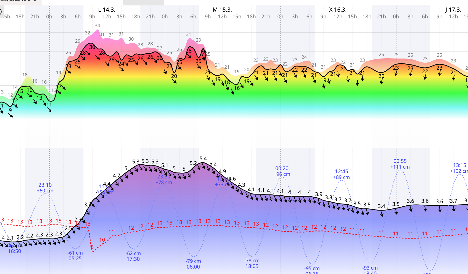
Tide predictions here for 15th & 16th may reach 6 m (20 ft).

Captura_de_pantalla_2022-03-13_a_las_213439.png


A black swan to a turkey is a white swan to the butcher ... and to Boeing.
 
In the us, shows real time water levels.
Modeling of future tidal and tidal area flood levels (about 1 week) is available at It's not tidal, but live level of rivers is available at NOAA River Forecast Centers
Many other countries have similar networks.

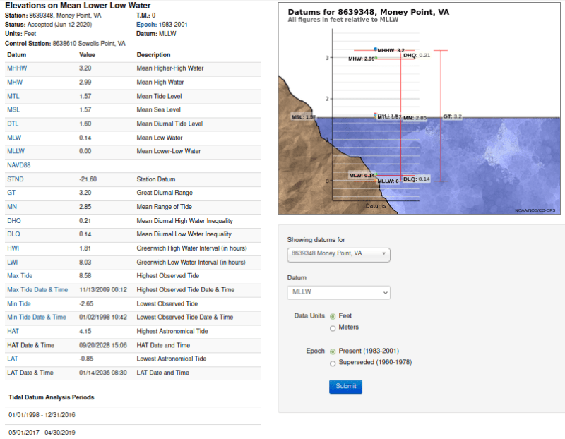
This is the published list of tidal levels at monkey point.
[URL unfurl="true" said:
https://tidesandcurrents.noaa.gov/datums.html?id=8639348[/URL]]
Screenshot_from_2022-03-15_18-08-18_ojttzu.png
 
Status
Not open for further replies.

Part and Inventory Search

Sponsor