Eng-Tips is the largest engineering community on the Internet

Intelligent Work Forums for Engineering Professionals

What tools are available to streamline conversion of old jacked up FEMA PDFs into HEC-2 input files?

Status
Not open for further replies.

beej67

Civil/Environmental
May 13, 2009
1,976
0
0
US
I, in my naiveite, had thought that my days trying to do flood studies off of old, nearly illegible HEC-2 printouts without any digital backup data were long gone. Unfortunately, this appears not to be the case, and I seek advice and assistance.

If you're as old as me you've seen things like this before:

screenshot_wlwmy4.png


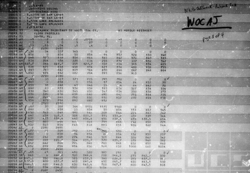
My decades old recollection was that the way to work with this sort of thing, when FEMA hands you that and that alone as the effective model for a CLOMR or LOMR, was to hand type each number in that printout into a text file, rename it a DAT extension, hope you got your columns exactly right, and then either try and run it in HEC-2 in a DOS shell or import it into HEC-RAS.

I really don't want to have to do that.

Are there any better options available nowadays? Excel templates to enter the data so the columns align properly? etc.

Hydrology, Drainage Analysis, Flood Studies, and Complex Stormwater Litigation for Atlanta and the South East -
 
Replies continue below

Recommended for you

with modern day OCR, you shouldn't need to hand type it

but in reality, that appears to be at least 30 or 40 years old. do you really trust that old data? shouldn't you re-survey, update the hydrology and re-model it anyway?
 
I agree with cvg. If I were given this task, I would request the GIS data from FEMA or local FPA and establish existing conditions based on new survey or LiDAR data. I had a very similar project, luckily our local FPA had experience with the original model and knew it was WAY OUTDATED. We agreed to re-establish existing conditions as a new corrected effective model. I used the scanned work maps along with the FPA's approval to "FIT" the work maps to current LiDAR data and then cut cross sections at the approximate locations as shown on the old work maps. Ya Ya I know, its a long way to say work with your local FPA to establish your scope of work and boundaries. Good luck and I will say that I really enjoyed the project I did, it was lots of fun!
 
Yeah, I'd love to do that, but can't because of inter-agency and inter-engineer politics.

A current georeferenced HEC-RAS model exists for this reach, done by one of the big companies (y'all know them, begins with a D) and their model was developed for the county but they never took it to LOMR for some reason I'm not privy to. Probably because the county didn't want to have to shell out for the necessary survey on the reach. So now the county has a good model, but the FIRM is still based on this ancient one, and "D" doesn't want us to use their model for our CLOMR since it's their model, and the county wants us to use "the effective model that FEMA has" because they don't really understand the conundrum.

So a model exists that would make more sense to use but I'm not allowed to use it. I don't really know whether FEMA will let me establish a new BFE through our project for this one road crossing without doing the work for the entire creek, which in theory should have been D's job but D might not have been contracted to do it. Yet. Or something.

Long story short it's a tangled mess and the locals have told us to use the God awful ancient printouts.

What's the peanut gallery's experience with FEMA in situations like this? Are they generally okay with throwing out the effective model for a short stretch and replacing it with better methodology without having to re-do the whole reach?


Hydrology, Drainage Analysis, Flood Studies, and Complex Stormwater Litigation for Atlanta and the South East -
 
Beej - Have you asked FEMA for the old HEC-2? I know some of the old models can be found on their website, (I think this is the correct link). Otherwise, you can contact them directly and request the model. The last time I requested a model and work maps, it took over a month to get them. Good Luck!
 
That's where we got it. FEMA said "here's your model" and sent us PDF scans that looked like that, with no digital copy of the input or output files themselves. Therein lies the rub.

If we applied for a CLOMR with a "from scratch" HEC-RAS model of our project area that tied visually with the upstream and downstream limits, and just claimed that was the corrected effective, do you think they'd buy it or would they bust us down to "using the effective model" for the study? They've done that to me earlier this year - I had a more updated model maintained by the locals, tried to do a CLOMR with it, and they said to scrap the work and go off of their copy of the effective model. I'm afraid they'd do the same thing to me here, but bust me down to the PDF printouts instead.


Hydrology, Drainage Analysis, Flood Studies, and Complex Stormwater Litigation for Atlanta and the South East -
 
Status
Not open for further replies.
Back
Top