Eng-Tips is the largest engineering community on the Internet

Intelligent Work Forums for Engineering Professionals

Dam Failures in Derna, Libya 25

Status
Not open for further replies.
Replies continue below

Recommended for you

A "wadi" is also called an arroyo in Spanish and a dry wash in Western US English.

During WWII, a large group of German troops set up camp in a wadi (perhaps this one?). It rained. That benefited the British.

From this, I decided that a wadi/arroyo/dry wash was a poor choice for long-term encampment. Which appears to be what just happened in Libya.


spsalso
 
Spsalso, what country? Alt. orollo, or... a barranco (revine). Arroyo is the stream in my usage, although depends what country and dilect. Spanish is not widely consistent across regions and can be very different between countries.

But yes, a wadi is a very steep, if not vertical revine. Extremely dangerous (obviously) during rainstorms as they are usually in bare rick with minimal vegetation. All water runs off and at very high speed and there is no escape route up the sides.

Comments left on the blog say...
There is also a pre-failure video from March 2023. Note that the shaft spillway and its surroundings appear very clean. This seems to indicate that an overtopping of the dam is unlikely to be the cause of the failure.

So may have been a blow out below, or tunneling erosion.

--Einstein gave the same test to students every year. When asked why he would do something like that, "Because the answers had changed."
 
"arroyo", as used in the US. And, quite likely, Mexico.

FWIW, I just missed going to Arroyo High School, down in Los Angeles.


spsalso
 
"Wadi" is a term used in Arabic countries, which just means a river or stream which is dry most of the time. Can have steep sides, but not necessarily.

That vertical structure is not a "shaft spillway". It is an inlet or control tower. It would allow some water to escape, but miniscule in relation to a properly designed emergency spillway.
 
The design/integrity of the dam structures may have had little to do with this disaster. The drainage basin of Wadi Derna is significant and exits above Derna through a narrow gap. Storm Daniel delivered tropical rains to the entire region and overwhelmed the infrastructure or any that might have ever been planned. Once the dams let go, they flooded the city which was already inundated with a foot of rain where normal amounts are measured in fractions of millimeters.

The circumstances were far more grave than the flooding of B.C./Washington several years ago where action on disaster planning could have mitigated much some of the damage.

Wadi_Derna_jsoe9e.jpg

Wikipedia

Derna_Drainage_mjbw29.jpg

Relief exagerated

Wadi_Derna.02_ylwljl.jpg

Relief exagerated

d837daf7-c144-4bb1-9c41-f36c7836fc76_umltyk.png

reliefweb.int
 
Sym P.le said:
Storm Daniel delivered tropical rains to the entire region and overwhelmed the infrastructure or any that might have ever been planned. Once the dams let go, they flooded the city which was already inundated with a foot of rain where normal amounts are measured in fractions of millimeters.

It's my understanding that this region typically gets all of its annual rain within a few days. I don't think this storm was extraordinary.
 
I have no idea about that region's typical climate. But topography tells a story about it's past. Those canyons aren't there by accident, they are there because millions of years of erosion by rain have put them there. Flooding might not be common, but when it occurs it is dramatic. Not a whole lot different in parts of the US canyonlands.
 
According to Google (yes, I know, not a 100% reliable source!), the average annual rainfall for Derna is 330 mm, while Storm Daniel delivered something like 100 mm in 3 days. I suspect this event was "extraordinary" from the perspective of the local population, but probably well and truly within the range of what the dams SHOULD have been designed to accommodate.

Fifty or so years ago, designing a dam for 100-year or 1,000-year events might have been normal, but even then, there should have been an emergency spillway to pass bigger flood events - e.g. for a major rainfall event when the dam is already full. From the aerial imagery, I can't see any sign of an emergency spillway on either dam. Once you get overtopping of an earth dam wall ...

The upstream dam had a significantly bigger capacity than the downstream dam on the city's perimeter; the flow of water from the failed upstream dam would have overwhelmed the downstream dam very quickly.

 
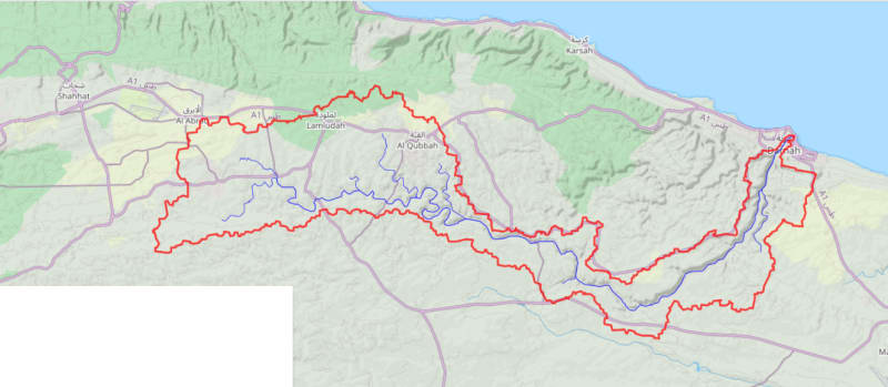
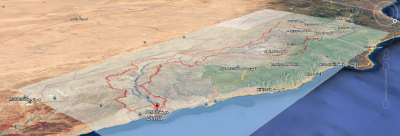
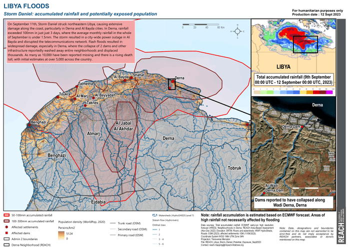
This storm was an extreme event, not typical of the season.

24h rainfall rates were measured at up to 440mm in Greece, shorter term rates were estimated at up to 300 mm/h, showing the receipt of very high volumes during very short time frames, some storm events lasting only 1 hour during which many areas received 40 to 77% of their total expected yearly amount. This is also not the usual rainy period in the region, more normally during March to May, and Nov-Dec. This time is normally still hot and dry. Summer does not end until 21 Sept.

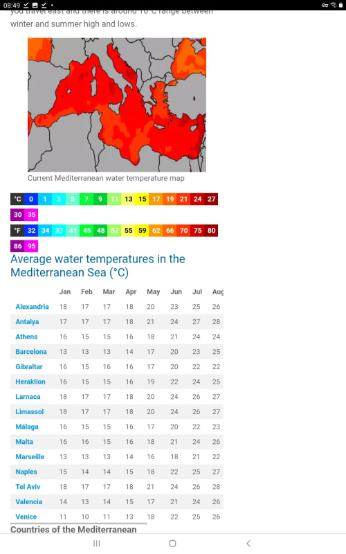
Current Med temp measured at 27.5°C 83F off Libya. Med is at all time max recorded temps. That same ole +1.5°C keeps popping up everywhere, even in my latest highest monthly average max kitchen temperature. 5yrs ago it never passed 25-26.

Screenshot_20230915-084914_Brave_wizkmg.jpg


Not restricted to Med.
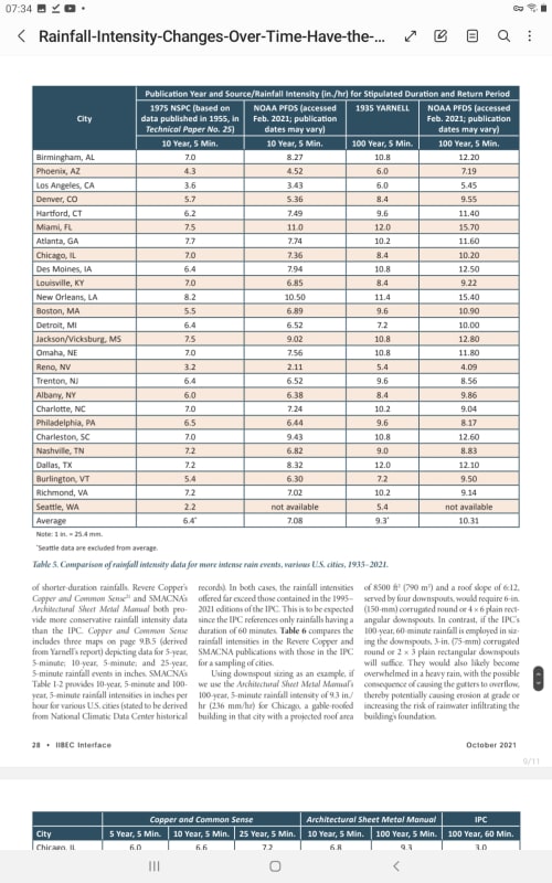
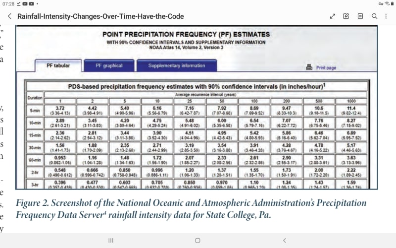
NOAA latest precip amount intensities and return periods are here,
check them against your old local building codes, they may be 34% or more higher for storm prone areas. Check Charleston SC 10 yr. Now Miami at [highlight #EF2929]+46%[/highlight]

Screenshot_20230915-073453_Samsung_Notes_vwetzw.jpg


Screenshot_20230915-072832_Samsung_Notes_khkjhk.jpg


Offshore Gulf of Mex platform design criteria was revised back in in 2010 to consider frequent CAT 5 storms.

Don't look up.

--Einstein gave the same test to students every year. When asked why he would do something like that, "Because the answers had changed."
 
1503-44, how is any of that pertinent to the Wadi Derna flooding due to Storm Daniel? 100 mm in 3 days may be extreme in that part of the world, but any dam should have considered rainfall of that magnitude, if not much greater. The design, if there was one, was totally inadequate, and the worst part was the lack of emergency spillways. There likely would have been significant flooding over the spillways, but not as catastrophic as what occurred. The stated purpose of the dams was flood control for the city, and they spectacularly failed their mission.

 
Actually I don't think we know if the dams spilled over or damage was caused by some other defect, or what event magnitude and frequency it was designed for. This was the same storm that came into Libya from Greece.

I'm just saying that storm events are significantly increasing in magnitude and, if you are involved with drainage and storm resistance design, a check of your building code requirements against the new data might be prudent.

--Einstein gave the same test to students every year. When asked why he would do something like that, "Because the answers had changed."
 
The question is, can all contingencies be accommodated at any cost. Historic rainfall over broad drainage basins may be one contingency to many. Then we can get into the specifics of who is correct about the rainfall totals. The relief agency map suggests 100 - 300 mm (4" to 1') of rain over the entire drainage basin, and regardless of time period, that surge would have to be metered by the two dam structures above Derna.

I would not venture out beneath any North American dam structure that is over topping with greater volumes yet to be realized. These things are not crash tested.
 
I'm with 1503-44 on this...it's my last hope for a purpose of this forum...how many of us will design an earthen dam in our career? Probably not a lot. But a lot of us do design structures that have to deal with rain load in other ways, and using this disaster as an opportunity to reflect on our practices and assumptions in tangentially related fields is the greatest benefit of this forum as I see it. After all, I doubt the NTSB checks in here for ideas.

We base a lot of our engineering to resist environmental factors on statistical models. That's great, but we have to be open minded about the base data and accept that it may not be as reliable as we think. This is especially true when an upward trend in the model output presents itself, suggesting that we lack a sufficient data set to forecast some of these events. If we run the model every 5 years and expand the data set and the result is not converging, we need to consider other sources of data and observation to inform our design assumptions.

The ASCE 7 hazard tool presents rain fall rates based on the Precipitation Frequency Data Server linked to above, and the newer editions point to those for structural engineers to design roof structures that have the potential for retaining water. Unfortunately, plumbing codes seem to be lagging behind and are creating a mismatch in expectations. I haven't had it happen yet, but I've come close to "code compliant" plumbing designs resulting in excessive retention on the roof now that I'm designing for more stringent requirements.
 
Status
Not open for further replies.
Back
Top