Continue to Site

Eng-Tips is the largest engineering community on the Internet

Intelligent Work Forums for Engineering Professionals

  • Congratulations KootK on being selected by the Eng-Tips community for having the most helpful posts in the forums last week. Way to Go!

French Drain Install In Clay Soil

Status
Not open for further replies.

MikeLivz

Mechanical
May 4, 2020
7
Hello All,

I am new here and am in the process of undertaking a drainage project for my backyard.

Details: Very heavy Clay soil in Northeast Ohio
Intend to run 3 4 inch rigid Perforated PVC pipes approx. 20-30 feet between each other approx. 200 feet long in parallel. Then, connect those 3 with a horizontal pipe at the end which will connect to a 6 inch solid PVC pipe and run to catch basin. All with very gradual bends and no 90° Fittings anywhere.

I plan on having a trench 12" by 12". There is a slope to the basin already but with no drainage installed and stays very soggy and muddy after a rain for a few days at the very least.

I am not sure what to line the Trench with. Concrete sand. #57 Gravel or both. With or without fabric?

Any help will be appreciated. Please let me know if any of my assumptions are not correct as I have stated above.

Thank you,

-Michael
 
Replies continue below

Recommended for you

Fiirst off. Why the 20 - 30 ft. spacing? If the clay is what you say, probably a clay from wind blown silt after glaciation. I'd question getting much improvement at that spacing using draw down to the pipes.. If you know the flow direction of ground water, any drains should be placed to cut off the flow. You might try one drain cross wise to flow and install some perforated vertical pipes down hill to see if you lower the water level down stream at all. Also, if you get only any small improvement, try going deeper, say 4 or 5 feet.

Then comes the collection pipes. With perforations on the bottom 1/4,concrete sand alone works well usually. Holes no larger than 3/8". 1/4" less sand gets in. If in doubt about keeping sand out of the pipe, wrap with fabric. I'd question using gravel especially if amateurs are doing the work. For some strange reason gravel, etc has been used a lot with the hope the open voids carry water. They also carry mud.

Interesting stuff. My grad school thesis on this subject back in the mid 50's.
 
Thank you for the quick reply and the info!

I was thinking the spacing because of the large are and the yard slopes vertically and horizontally. Even at the highest point it is very wet. Found this out when planting some fruit trees about a month back.

I do get some water settling toward the lower northeast half of the yard though where the slope settles a bit. Gotcha on the sand and the fabric. Is there a certain fabric I should use? Landscaping fabric or some other type?

Once I get home I will take some pictures of my yard and the soil that I am dealing with.

Thanks for the help thus far.

-Michael
 
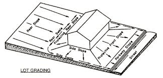
In my region lot grading plans are built into the approvals for subdivision, if your in a subdivision you may need to look at the impact of any changes to your drainage quantity and discharge location. I also find it odd you are considering drainage pipes for backyard grading instead of swales, which are typical. If you are planning on ripping up three 12 inch strips you might consider grading the entire yard to get water to perimeter swales. The below image is from Greene County in Ohio, and shows a back to front drainage pattern, other common types are front to back and split.

image_htaj1u.png
 
Thank you for the reply and the info!

I am not in a subdivision. I am on a little over 6 acres in country area with little regulation on what we can do.

I like the idea of the swales but I am unsure if these will work for my application with regards to access around them and the look of them in the yard itself.

I am open to ideas though. I will upload some pics later that will help all this come to more visualization for everyone.

Thanks again for the help.
 
Give some thought to something like this. This depends on the test trench I mentioned. If you can use a small trencher that say digs a trench 5" wide or so and at least 24" depth, preferably deeper. Spacing and depth set only after a test trench to guide. Say you decide on 10 ft. spacing and 2' depth. All these are cross wise to the slope, parallel to contours.. Fill with concrete sand except 6" on top as original soil. Then parallel to the slope you install a drainage collector pipe, the perforated pipe with sand backfill as a collector from these narrow trenches. Whether or not one perforated pipes very 100 feet or so will do depends on what you see collected by one. I'd not set any spacing until you get a better handle on how a trench drains the stuff beside it. Those collectors might instead be placed like fish bones feeding to the perforated pipe. But you need to know first what spacing of collectors. In a test trench for the narrow sand filled ones, you need to know how often to put a collector pipe to pick up the flow. if it is slow, longer spacing.
 
a sand filled trench with a 6 inch clay cap will likely intercept very little surface water. french drains are really only useful for lowering groundwater.

assuming that the wet ground is due to surface water (from rain), than your first step should be grading as recommended before to drain the water across/off your property or at least away from your house. You need to remove that water as quickly as possible, during the rain and after so that the surface can dry out. if you still plan on piping, than build a proper storm drain with surface inlets that will collect the water at the ground surface and drain it to a ditch.
 
This old guy has been involved with this subject since mid 50's. Sounds to me like shallow ground water table is the problem, not surface water.

Edit, so solve this point before going farther
 
If this site is bothered with surface water, you don't use a perforated pipe and sand backfill in a shallow trench. Reason is, in time surface dirt will plug up the sand. So how to check for surface or ground water. Likely the surface water is only there in wet weather. Whereas the ground water near the surface leaves a spongy situation even in dry weather, until it dries further from weather, depending on where it comes from..
 
Thank you for all the replies and advice to get started.

As regards to surface or groundwater it is definitely ground. I do not have much surface water. It seems to be held in the clay causing a very soggy ground situation.

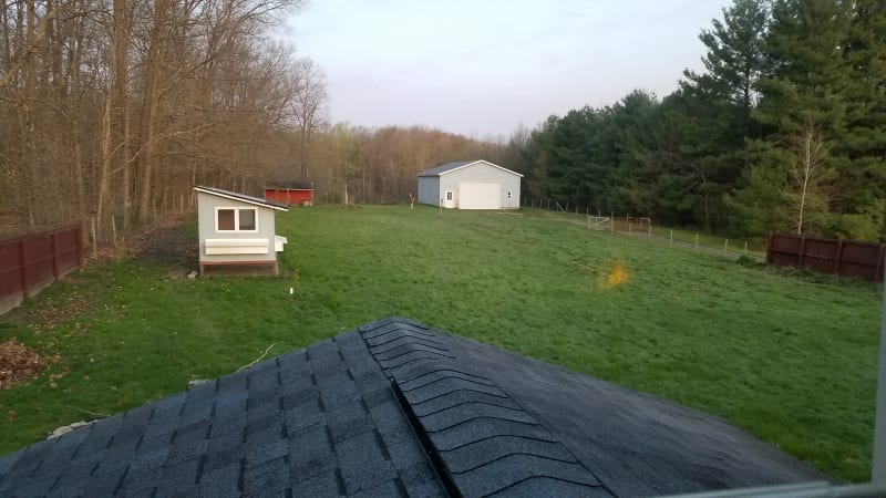
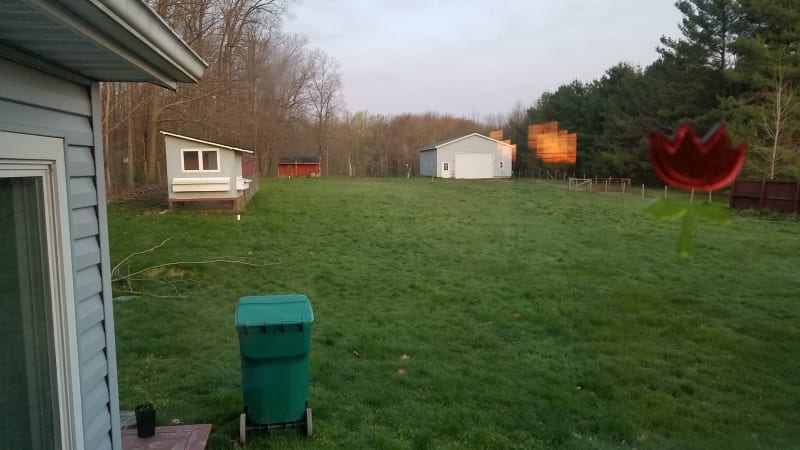
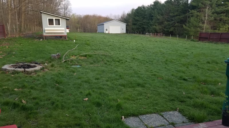
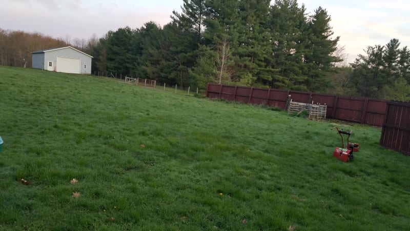
I will see about doing the test trench later this week and report back my findings. I have also attached a few pictures of the site I have been referring to.

Thanks again and just have to say, this is a great website.

20200505_060541_cvagva.jpg

20200505_060551_iiqog4.jpg

20200505_061545_ousp6w.jpg

20200505_061605_fdcfhn.jpg
 
Hey guys,

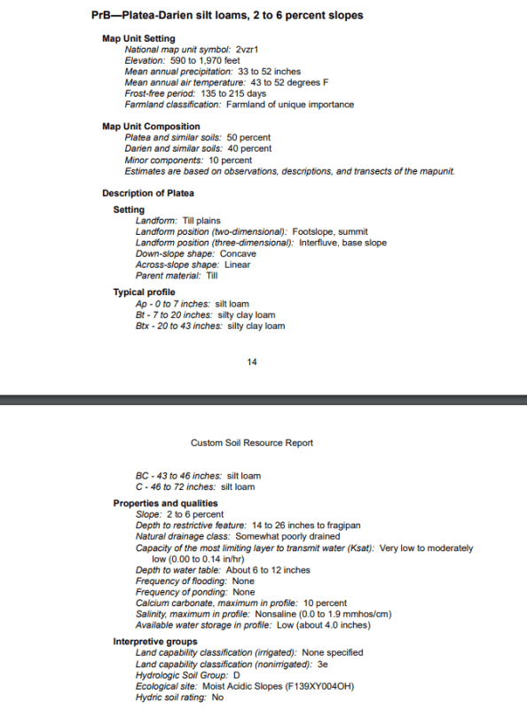
I have also attached the excerpts of the soil survey of the land. I hope this can help with what I have told you thus far and clear up any confusion.

Also, help me learn about what I need to do.

Site_Soil_Survey_zvu2ge.png
 
The AG soil info is great. This soil is somewhat capable of being drained with sub-drains. However, they have to be deeper than your original 12 inch depth to do any good. I'll look up the soil name and perhaps ground water depth will come up. Many times those names are used in other states and sometimes not. I'd like to see if they have what is called structure (by ag soil scientists). Tell that description to an engineering prof who teaches soil mechanics and you get a blank stare. That is cracks formed by annual drying and wetting leaving what are called "peds'. Means drainage is possible.
 
I noticed the perimeter vegetation outside the fenced area, in my experience you will have finer grained material or lower permeability soils near the pine trees. There is also a compacted driveway (which will act as partially cemented and water will pool in ruts) on the right side of the picture which I assume is blocking drainage to the right.

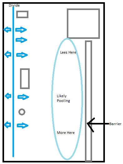
I would assume that you will be finding more soggy and muddy conditions on your lawn closer to the right side of the pictures before the driveway. In comparison the left side near the fire pit and red shed appear somewhat elevated and a surface water divide likely exists to the left of the small structure with a sloping roof. I believe the driveway is acting as a barrier and may be causing local pooling which will take longer to infiltrate due to a transition to lower permeable soils on the right side of the property. Below is a sketch of what I suspect is the problem. The solution may be to put a swale on both sides of your driveway and put in some small culverts. Also the fence on the right side closest to the house may be limiting surface water runoff if it is right on the ground.

image_bkdh6j.png
 
Looking at the soil report for the area it says 72 inches of low permeability materials, somewhat poorly drained and water table 6 to 12 inches. From the photos I find it hard to believe the water table is that shallow. If this was a groundwater problem I would think you would notice foundation or buried utility connection issues.

I would ask the following questions
Does you home have a basement or is it a slab on grade?
If you have one does the sump pump run frequently? Also where are you discharging your gutters and sump pump to?

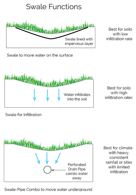
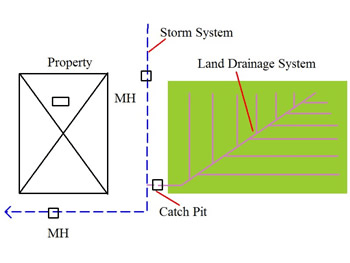
If this is a surface water problem pooling water you would only need to do slight grading and any low spots you would need to connect with swale to culvert system or a catch basins/culvert system to a lower level outlet. If this is a groundwater problem you would need a lot of earthworks and you would want to cut drainage channels in a leaf pattern to a low elevation outlet on the perimeter. I don't think the problem would be as extreme as football fields which can have uniformly spaced drainage pipes and closer spacing for perpendicular sand groves.

Swale schematics
image_f67qrn.png


Catch Basin system to connect low points
image_jhuwy0.png


leaf pattern drainage system
image_jl3rjs.png
 
regional soil surveys cannot be relied on to give accurate information of water table depth or anything else for that matter. you need site specific data. you need to dig a hole until you hit groundwater. dig it at least two or three feet deep and leave it overnight. measure the water the next day (assume it doesn't rain). then examine the material from the hole to determine if it is silt, clay, loam or something else.
 
This OG differs from this comment in the USA with the soil scientists here.

regional soil surveys cannot be relied on to give accurate information of water table depth or anything else for that matter

Tied into air photo analysis, I've found the USDA work to be amazingly precise.
 
Yes my home does have a basement and I have not seen any water in there as of yet.
I also have a sump pump but it does not run frequently that I can tell.
I am not sure where the discharge goes to, that I would have to track out to see.
I do believe the water table is fairly correct though at least during the winter/spring time. I have dug quite a few holes for trees and bushes on the property and at about 8 inches or so I see Standing water in the hole. Some areas a little less and some a little more. The hole will gradually fill up to about a third of the way if left alone for an hour to a few hours.
I do think this ground is a clay type substance. It is vert sticky, wet and heavy.
I also think the soil surveys are fairly accurate as I have checked multiple sites that I know the soil to be and they were dead on from what I knew they should be.
So do you guys think the leaf pattern design would be the most suitable? Would I line these like you do a french drain or just rock or gravel and topsoil on top?


Wait with any definite pattern until a little test. That test of a drained trench with sand fill and a pipe might be simplified some if you run a drain pipe to a pit that is pumped. A long drain to daylight might be needed for a test trench if suitable depth.. From the Ag soil description, I'd guess that you do not have full saturation all year, due to soil color not being mostly gray. Gray means lack of oxygen for iron to oxidize.

Edit. That house perimeter drain system might be a good clue provided you know were it drains.

More: Where does the water go? If to a septic tank and a tile field,what is the field like? Any problems?

More More: What happens to house roof water? Gutters" Dumps where?

What is that circle thing in back yard?
 
The image below is from the USDA National engineering handbook for drainage regarding recommendations for geotextiles or sand filter envelopes in trench's. You can easily dig up some test holes to get samples just above your target elevation across the property and run simple "mason jar test", google it, to see how the material plots. If you find your material is well within the clay region you would need a geotextile to line the entire trench and remove all the clay backfill as it will eventually clog your drain, you would want to use more sand/gravel and separate garden center topsoil with geotextile.


image_vqghwb.png

 
Thank you again for all the tips and advice on this.

To answer a couple questions:
I am not sure where the house drainage goes to. I do have a septic with a leach field and I do not seem to have any issues wit that,
The gutters I would have to track out and see where they go. Planned on doing this but had some cold weather and a few other things going on.
If you are talking about the green color circle in the ground, then that is the septic tank cover.

GeoEnvGuy: According to your picture of the troublesome areas you are almost 100% correct. The only area of correction is the area of pooling. I do not get pooling until the lower half of the right side where you have it labeled as "More Here" The driveway has some low spots and those always have pooling in them after a rain and a few days after. I also have very wet soil on the upper left side of the picture as well where the divide is located at.
 
Status
Not open for further replies.

Part and Inventory Search

Sponsor