Eng-Tips is the largest engineering community on the Internet

Intelligent Work Forums for Engineering Professionals

Hwy 1 South of Monterey CA Roadway Closed (Again) by (New) Mudslides. Jan 28, 2021 3

Status
Not open for further replies.

racookpe1978

Nuclear
Feb 1, 2007
5,968
0
36
US
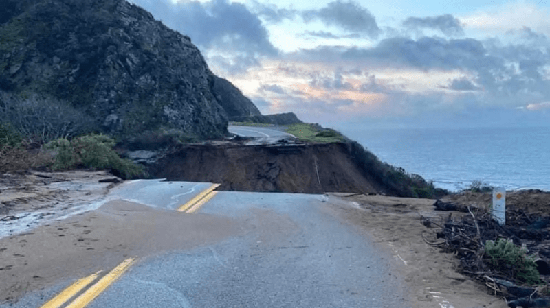
Few details are available, and almost every on-line link and associated photos I find refer back to the May, 2017 Hwy 1 collapse at Big Sur that recently finished rebuilding/re-routing, but the California Coastal Hwy 1 was closed south of Monterey CA due to new mudslides Thursday (28 Jan 2021) and Friday (29 Jan). Both lanes are wiped out.

Cross-connecting roads back inland from Hwy 1 are few and (literally) far between in almost all sections of Hwy 1 between LA and Monterey, so traffic must backup nearly 20 miles on each side of this latest break to reach detours back inland.
 
Replies continue below

Recommended for you

Yes, it was the Pacific Coast Highway (AKA CA-1). The 101 does not run along the coast, but rather inland, through the coastal mountain ranges:

Screenshot_2021-01-31_Part_Of_California_s_Famous_Highway_1_Just_Fell_Into_The_Pacific_Ocean_w8i7pg.png


Part Of California’s Famous Highway 1 Just Fell Into The Pacific Ocean


John R. Baker, P.E. (ret)
EX-Product 'Evangelist'
Irvine, CA
Siemens PLM:
UG/NX Museum:

The secret of life is not finding someone to live with
It's finding someone you can't live without
 
A continuing fight against nature. Beautiful one day, gone the next. It is one of the most scenic byways anywhere, but a maintenance nightmare.
 
fires not retaining moisture or holding the soil together? Is this an area of a recent burn?

Rather than think climate change and the corona virus as science, think of it as the wrath of God. Feel any better?

-Dik
 
I don't think so. The real culprit was the rain, pure and simple. The storms that worked their way up and down the coasts of California this past week were pretty significant. We only got about an inch and half of rain down here in OC, but further North, they got way more than that.

John R. Baker, P.E. (ret)
EX-Product 'Evangelist'
Irvine, CA
Siemens PLM:
UG/NX Museum:

The secret of life is not finding someone to live with
It's finding someone you can't live without
 
I think if they post a mandatory minimum speed limit you could still get across that.
2pt4b3o.gif


That was caused by a creek that drains a LARGE area of several very steep joined ravines. A mudslide brought down a bunch of trees that backed up the under-road culvert with predictable results. The repair will take a while and I expect it to be in the form of a bridge so further debris can't cause a relapse. And, there will be more debris because the steep canyons are filled with trees. A pile of trees has created a backed-up dam forming a lake just above this at the moment.

I have an upcoming job at the Bixby Bridge so I think I can still get there..

Keith Cress
kcress -
 
I'd call it a movement... [bigsmile]

Rather than think climate change and the corona virus as science, think of it as the wrath of God. Feel any better?

-Dik
 
FYI...The washout occurred at Rat Creek, which is about 15 miles south of the town of Big Sur and 6 miles north of Lucia Lodge. Looking at Google Earth (36° 5'31.46"N, 121°37'6.81"W), there was no bridge here, so the creek would have crossed under Hwy 1 in a culvert. A culvert that is now gone.

During the recent storms, Cambria--about 48 miles south of the washout--received >10" of rain and Ragged Point--about 27 miles south of the washout-- received >13" ( I suspect the coastal mountains in the Rat Creek watershed may have received 15" or more over about a two-day span.

On the other hand, the airport at Monterey--about 36 miles north of the washout--received only about 4 inches ( Nearby Carmel Valley, which is in a bit of a rain shadow, was about the same per WeatherUnderground. We received about 3.4 inches in Fresno, which is nearly 1/3 of our annual average.

Back to Rat Creek. Using a Google Earth polygon, I roughly estimated the size of the watershed to be about 3.4 sq mi, with a covering that is about half trees (probably oaks on the hillsides and something else in the stream beds) and half scrub. The longest drainage path is about 1.6 miles long and drops from an inland elevation of about 2750 ft down to about 225 feet at Hwy 1, for a watershed height of about 2525 ft. That's an average slope of 30%. I want to look more into the hydrology, but I will have to research to see what type of information I can find for this relatively remote area...and it's lunch time so it will have to wait. :) Maybe somebody who does large watershed hydrology more often than I do can take this on.

BTW, my wife and I know this part of Hwy 1 fairly well, having traveled it about a dozen times over the years, sometimes north to south and sometimes south to north. A couple years ago, my wife and I camped for a week at Limekiln State State Park, which is only about 2 miles south of Lucia Lodge. During this trip, we took a day to drive up Hwy 1 to visit the Monterey Bay Aquarium, so we drove through this spot twice. Back in high school in the mid-1970s, my wife (then only an acquaintance) and I were part of a week-long 240-mile bicycle trip with about 90 other high schoolers from Big Sur to Santa Barbara. Riding on the outside of Hwy 1 is quite the experience. In many places the paved shoulder is only about a foot wide, then there may be a few feet of dirt, and then there is a steep drop-off to the ocean. The good news is that the we didn't lose anyone over the edge. :)

Fred

============
"Is it the only lesson of history that mankind is unteachable?"
--Winston S. Churchill
 
We last drove Hwy 1 from LA to SFO 43 years ago: Our youngest, then 2, was in the carseat in the middle of the station wagon. Urpped all over everybody (including my loving chemical engineer wife who was strapped in beside him) after 4 hours of up and down twisting and turning roller-coaster driving. And then we couldn't stop and effectively clean up or change clothes or do anything (no rest stops, no gas stations, no restaurants, no motels) for another 40 miles!
 
Pure and simple poor drainage structure. Obviously, the culvert was undersized for the peakflow experienced during this storm event. Additionally, the watershed didn't just experience a large surge in water flow but debris flood as well. Culverts are seldom used on crossing with a high likelihood of debris flows. They're really are a poor choice unless other measures are in place to address debris.
 
Status
Not open for further replies.
Back
Top