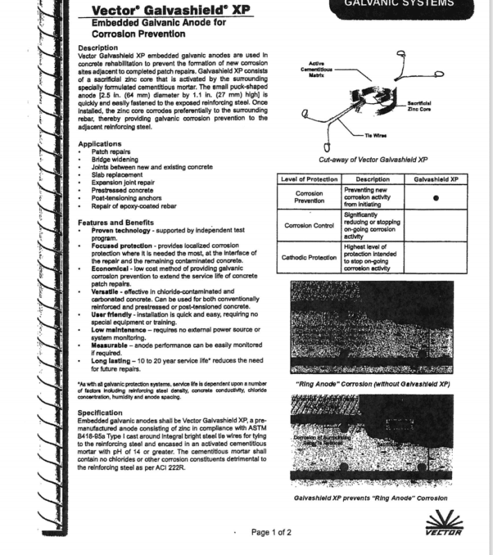
Eng-Tips is the largest engineering community on the Internet

Intelligent Work Forums for Engineering Professionals

Miami Beach, Champlain Towers South apartment building collapse, Part 08 20

Replies continue below

Recommended for you

Conspiracy?
*puts on Inconel718 hat*

And yes, I was blurring two things. Dumbdumb over here has to go find what he was referring to with the column exploration. It may not have even been work that was done yet. I got distracted by requirements over piles and core drills in the balcony repair permits and jumped to assumptions. Still have to read all of the hand scribble notes because I'm still not sure of the full scope of this repair. It was all over the place. Seems they did a lot of additional damage they had to fix, and they were rushed too because of other work schedules.
BecauseSurfside said:
Because Surfside
​I will post a timelapse soon that shows where the water comes from

​There will be a full moon on Friday. Tune in at 9 am for high tide; and 11 to 1 when the tide is going out. Let's see if the water is higher at 9 than it is at 1pm

The slab really is filling with water with the tides.
This will be interesting.


Edit: The dropbox link gives a 404. Was this the same permit, or was this different work?
Precision guess work based on information provided by those of questionable knowledge
 
arbitraria said:
this was in the "condo structure" permit file from yesterday's uploads.

Thanks--interesting reading.

So "we" did periodic observations of the progress of construction.

A strict reading seems to imply that Breiterman was hired as a separate act from the design work, and that hiring was prompted by the Zoning Department.


spsalso
 
For those watching the tide flood the slab, here’s where the tide was on the night of the collapse.

~11 PM, when Chani Nir came home to 111 and heard knocking sounds.

>>>>Deleted; see below.

~1:22 AM, when the building collapsed.

>>>>Deleted; see below.
 
SFCharlie, I satisfied your request for a PowerPoint document, but got caught in the transfer to this 08 version. Can you transfer my submission from the 07 version to the 08 version?
 
The moon was nearly full on June 23, 2021.

F7E90725-5623-46B0-9E47-DB5A114EA212_pgfyld.png
 
Have you seen the relative heights of the garage floor vs sea level, and/or what the known standing water level is round there? The figures I've seen here I've seen all reference +/- grade (I think) but I have not seen what grade is vs permanent datum. I like your idea of a concrete canoe (now a leaky one) but it would be good to know how close to standing water it really was.
 
AusG said:
Have you seen the relative heights of the garage floor vs sea level, and/or what the known standing water level is round there? The figures I've seen here I've seen all reference +/- grade (I think) but I have not seen what grade is vs permanent datum. I like your idea of a concrete canoe (now a leaky one) but it would be good to know how close to standing water it really was.

T.O. Basement Garage Slab: -0.27ft NAVD.

It’s important to note, the critical tide height level is from the Biscayne Bay side, not the Atlantic. The tide levels vary greatly and it’s necessary to use the appropriate reporting station for analysis.
 
AusG said:
Have you seen the relative heights of the garage floor vs sea level, and/or what the known standing water level is round there? The figures I've seen here I've seen all reference +/- grade (I think) but I have not seen what grade is vs permanent datum. I like your idea of a concrete canoe (now a leaky one) but it would be good to know how close to standing water it really was.
Does the floor level at this point matter when the piles are known to be in the location of a former body of flowing water?

Tide go in, tide go out. Sand goes with, and what good is a pile in the sand with no bedrock attachment with flowing water?

Precision guess work based on information provided by those of questionable knowledge
 
MarkBoB2 (Electrical)22 Jul 21 00:28 said:
At the request of SFCharlie I have uploaded a PowerPoint file with this submission containing the four images shown in my last submission. Hopefully this will improve the resolution of the images. It will also allow removing some or all annotation over the images to permit viewing any objects obscured by the annotation.
For anyone without a PowerPoint application, I suggest copying the JPG or PNG images from my last submission using your computer's COPY function and then pasting the copied image into either a Word or PowerPoint document before viewing. Both of these applications have zoom capability. When I did this on the images from my last submission, the resolution was only slightly degraded, probably because of using the Microsoft Paint application to create a JPG or PNG version of each image. If you still find the image resolution unsatisfactory, then it's likely because your computer display is not good enough.
Thank You!
( for those of us that don't have PowerPoint, I have attached each slide as a .png file in following posts )


SF Charlie
Eng-Tips.com Forum Policies
 
 https://files.engineering.com/getfile.aspx?folder=8aed0cdf-ceb9-420a-ae88-d5b7e069dab3&file=Photos_from_MarkBob2%27s_last_submission.pptx&__hstc=212727627.d02aad8153d2a769b00c69fc032590ca.1565231500701.1626912545040.1626916604945.607&__hssc=212727627.1.1626916604945&__hsfp=25083293
AusG said:
Thank you!

Anytime. Indian Creek Golf Course ICWW Station ID #8723094 is the nearest appropriate location.

Demented said:
Does the floor level at this point matter when the piles are known to be in the location of a former body of flowing water?

Tide go in, tide go out. Sand goes with, and what good is a pile in the sand with no bedrock attachment with flowing water?

Is that you Danny?

The bedrock was extremely shallow in that location, and if an image is taken at the right time, it’s possible to see remnants of the early dredging attempts off shore to connect Indian Creek to the Atlantic. Due to the difficulties encountered, a channel was created just north at Baker’s Haulover.

There are very few natural sand beaches south of Broward County. Almost all in Miami-Dade are man made. The texture is not what most would equate to beach sand. It’s more like a fine crushed and very dusty pumice.
 
Moved over from the other thread.

@Thermopile
This be the one.
2009 permitted work.
foundit6_hmpxxs.png

foundit_y0gvht.png

foundit1_f99f1g.png

foundit1_okv5z9.png

foundit2_vaitdz.png
foundit4_udymo2.png

foundit5_foewre.png

nospraygalv_f0a9et.png
n
nospraygalv1_l8uysz.png
nospraygalv2_bnmhyp.png

nospraygalv3_bvorgs.png


Small world. These guys are right around the corner from me.

Precision guess work based on information provided by those of questionable knowledge
 
Status
Not open for further replies.
Back
Top