Continue to Site

Eng-Tips is the largest engineering community on the Internet

Intelligent Work Forums for Engineering Professionals

  • Congratulations GregLocock on being selected by the Eng-Tips community for having the most helpful posts in the forums last week. Way to Go!

Rough survey using antique survey compass.

Status
Not open for further replies.

metal249

Automotive
Aug 13, 2013
14
Hello all, I'm trying to figure out this old Keuffel and Esser pocket transit compass. My goal is to use this to rough survey some family property, not officially survey, I'll have a pro survey done before anything is built, or fenced. If I can get it within a few feet, that will be good enough for now. I believe that, with this compass, I could survey the property, at least enough to know im driving on my own land. I understand how to find a bearing, but I don't know what the rest of it does. It appears to have two levels, a declination adjustment screw(for setting north?), and a strange lever that rotates on the bottom. The rotating lever has the two levels, and a pointer that that reads in degrees on one side and percentage on the other. This compass was owned by my great uncle, whom was a geologist for the Twin Buttes mining company. His job was to survey potential minesites in various parts of the world. Best I can figure is that this compass was built sometime around 1926-1930's-ish, and I cannot find a single resource that shows how to use this thing. I'm hoping you surveyors might know how to use this thing, or at least point me in the right direction. Thank you.
 
 http://files.engineering.com/getfile.aspx?folder=240251e1-f8a8-4d85-94b1-78fa0f316d9d&file=20160124_132543.jpg
Replies continue below

Recommended for you

Its two adjacent 121ftx297ft lots, total of 1.65 acres I believe. All the other lots in the block are the same size, which is how I'm measuring. Plus, the lot info has gps coordinates, which are the direct center of each lot.
 
The two levels are to get the plate flat.

Starting point. Can you establish a valid ("good enough") location to begin from?

Is +/- 2 foot adequate for the corners for right now?

How long a tape measure will you get? The compass can only give direction (from a point), not distance!
if it is two 121 x 297 foot "squares", then you'd want at least 150 ft, preferably 200 or 300 foot. Each time you move the tape to measure the next section, you introduce inaccuracies that promulgate down the line. Ideally, you'd want one tape line to measure the 297 foot length and the two front lines (242 ft total) at the same time on the same "line" stretch.

And you will need a tripod for the compass, and stakes or visible markers for the "corner" points and start points.
 
Hopefully there are already monuments (pipes, rebar, or concrete monuments with rebar) set at your property corners. If that is the case, the compass, tape, and a metal detector may be quite adequate to help you find your corners.
 
+/-2 ft is plenty, I just need a good enough idea of where the property is to drive onto it. My plan is to use pre cut lengths of string/twine/rope, hopefully something that will go 297 ft without stretching too much. I've already made a half-assed attempt at surveying it, this is what i did;

I gave a real estate buddy of mine the tax info, and he was able to find some info as to where the property is. The block they are on is split into 20 lots, with a divide in the middle, so 10 lots on the north side and 10 on the south side. Each lot is 121x297 ft. My lots are 13 and 14, and have 2 lots to the west and 6 lots to the east. I then went to google earth, and found the block. Earth showed a road to the west of the block, and being only two lots to the east, it was the shortest distance. My plan was to measure 242 ft from the road, and locate the survey stake near the measurement, which would be measured via smartphone gps. I cut two fence posts into four small temporary survey stakes.

I then went to the property, only to find two markers, a sign that reads "15", and an old 4x4 fence post about five feet in from the road. I walked east 242 ft-ish from the fence post, and could not locate a marker of any kind, so I placed one of my stakes. I then walked 242 ft-ish further east and placed a second stake. This second stake ended up about 15 ft short of the "15" sign. So, i assumed that this sign was the south west corner of lot 15, which would fit pretty well with my very inaccurate phone measurement. Ive been told that lot markers are usually in the middle, or on the south east edge of lots. If thats true, then im way off.

The only accurate starting point would be the 15 sign, or the power lines to the east, and possibly the post. So if I measure 484 ft from the post, using a buddy and a 242 ft length of small rope, and that is near the 15 sign, then its probably the south west corner of lot 15. I will then measure 726 ft using the above method from the power lines plus a few feet for the easement, and that should be close to the 15 sign. Once I verify that the sign is the south west edge, I'll measure 297ft north from the sign with the compass and a buddy, and place a stake at that point. Then, 242 ft bearing 270 degrees, place stake, then 297 ft 180 degrees, so and so forth. The compass is set at 12 degrees declination, which is correct for here I believe. I mapped the property with earth, based on the gps co-ords for the lots(exact middle of the lots), and took a screenshot.


 http://files.engineering.com/getfile.aspx?folder=42f80425-8cf8-4135-a3bc-77b707e19a49&file=earthshot.jpg
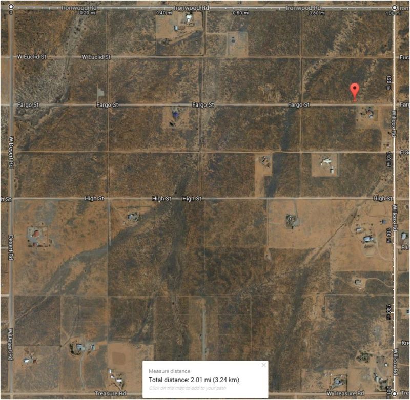
It would be best if you could find an existing physical property corner rather than just the road. Google shows that the roads are not altogether straight. I would initially search for a corner at Fargo & Wilcox. Even if you can find a marker for the house across the street and work back, I believe it would be better than measuring from the dirt road to the west. If you don't have one, borrow or rent a metal detector. The methods you use to measure will be meaningless if you are starting your measurements from the wrong spot.
 
How far off would 1/2 degree be at 297 ft? If we are talking a few feet, that would be fine, tens of feet would not. Also good to know that earth is that inaccurate. The only definite property marker is the 15 sign, and yes the road was impossible to measure from, it no longer exists. The wooden fence pole is set in a few feet from what was left of road, and about 5ft in from the main road to the south(Fargo st.). This is probably the southwest corner of lot 11, the first in the block. The 15 sign is on one corner of lot 15, or the middle of it, along Fargo st.

So, being that Earth is at best +/- 3m, I should measure from the sign. If that post is 484 ft west of the sign, then I could assume the sign is the south west corner of lot 15 and the southeast corner of lot 14. I just trying to come up with as many methods as possible for the next time I get out there. I could then base my measurements on that sign.


I put a place mark where I believe the sign should be on this pic.
 
 http://files.engineering.com/getfile.aspx?folder=c8f954f8-980d-416b-b471-b4f9d80e7a62&file=sign.jpg
You're going about this the wrong way in my opinion.

It's looks like Arizona is on the Public Land Survey system which means it is divided up into Townships, Ranges, and Sections. Each section is a square mile and contains 640 acres. These sections are usually oriented on the cardinal directions. The roads usually run around these section lines.

Each section is monumented at each corner with something permanent. Often a piece of rebar or piece of pipe in a concrete cylinder buried beneath the surface of the ground. The 1/4 corners (every 1/2 mile) are usually monumented also, as well as the center of the section.

Eyeballing the map I'd say your section is bounded by Ironwood to the north, Wilcox to the east, W Desert to the west, and Treasure to the south. That means there are monuments at or near the center of each of those intersections. You can find them with a metal detector. There might also be a 1/4 corner monument at High and Wilcox.

There should be a legal description that will describe how they got to your parcel starting at those monuments (AKA the Point Of Beginning). You need to get that legal description. It will tell you a lot.

Everything being on a grid, with the roads every 1/4 miles E/W and 1/8 mile N/S should get you pretty close.

I'd give up on your rope/string idea and use a wheel instead. You should just be able to figure out your distances using the legal description and wheel your way down the road to (close enough to) your lot corners.

How did you determine the dimensions of your lots? Are you sure they don't run to the centerline of the roads? If they do, they are 132' x 330' and finding the corners from the intersection with a wheel would be easy.

Google maps and a cell phone GPS is going to do zero for you but make sure you're in the right neighborhood.

temp_olb0wf.jpg
 
Such surveyor compass is described in my fourth edition text book" Surveying" by Davis and Foote. It is used to do traverses by placing such compass on a plane table, however, for rough surveys, I imagine that you could also use it by holding the compass, whereby you could establish bearings of boundary lines and angles. I have never used such compass but looking at your second picture I see a solid double headed pointer that would establish the magnetic poles and a "second" pointer that you would align thru the peep sight the next point where a rodman would stand. You or a third man could then do the chaining or taping to measure distances. Keep on repeating the procedures to successive corners. No elevation will be determined and peg each corner as you traverse the property. It will be a rough survey for sure.
 
The compass that you have is what we called an M-2 compass in the army. We used it to layout aiming stakes for our 120 mm mortars. It is a little more accurate than a decent compass for orienteering but not good enough for locating boundary corners unless you know where they are. As stated above it was also used with a plane table to establish topographical features for contour mapping. However I did use a similar compass once to retrace a 1780's deed call along a ridge line and got within 10 feet of the original stone corner.

Timothy W.Day
Survey Crew Chief
Power of Design Group, LLC
 
Status
Not open for further replies.

Part and Inventory Search

Sponsor