Navigation
Install the app
How to install the app on iOS
Follow along with the video below to see how to install our site as a web app on your home screen.
Note: This feature may not be available in some browsers.
More options
Style variation
-
Congratulations cowski on being selected by the Eng-Tips community for having the most helpful posts in the forums last week. Way to Go!
You are using an out of date browser. It may not display this or other websites correctly.
You should upgrade or use an alternative browser.
You should upgrade or use an alternative browser.
Sizing the photovoltaic (PV) modules for solar panel design 1
- Thread starter abdi mulu
- Start date
- Status
- Not open for further replies.
Ouch! Usually the government has mapped the entire country. You find that document and then find the location in it.
Alternatively you find, perhaps, a big city near by and extrapolate to the location of interest.
If you're doing a large scale job an insolation monitoring system is usually installed and watched for one year at the precise location of interest.
Lastly and worstly you find a same-latitude city that someone can confirm has the "same weather" regarding over-cast type and frequency and use that city's data with +/- fudge-factors added.
Keith Cress
kcress -
- Thread starter
- #3
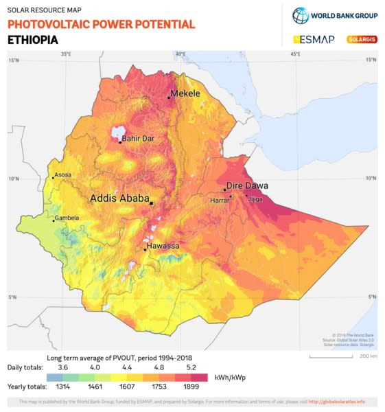
@itsmoked thank you for your response, but I couldn't find prerecorded data for specific location in Ethiopia, that I am going to design for. Do you know any useful software that may help me in approximating the panel generating factor based on a given coordinate?
LittleInch
Petroleum
do a google search. there are many websites which give you at least a reasonable answer. It should be pretty good as you're close to the equator and the sun time doesn't change that much.
I think it's close to about 4 for East Africa like Kenya.
See this e.g. - Did you do any research?

Remember - More details = better answers
Also: If you get a response it's polite to respond to it.
I think it's close to about 4 for East Africa like Kenya.
See this e.g. - Did you do any research?

Remember - More details = better answers
Also: If you get a response it's polite to respond to it.
- Thread starter
- #5
-
1
- #6
Abdi, the National renewable Energy Laboratory in the US provide a web based package called PVWATTS that allows you to calculate the output from a solar PV array. There are a range of input parameters including size, tilt, azimuth and importantly, location. The nearest average weather data is used in conjunction with your inputs to generate monthly and hourly PV outputs which you can use to size your system. A CSV can be downloaded. The URL is
Thanks for that info EnzoAus AND welcome to Eng-tips.
Keith Cress
kcress -
Keith Cress
kcress -
LittleInch
Petroleum
Neat - I've put this in my archive...
Remember - More details = better answers
Also: If you get a response it's polite to respond to it.
Remember - More details = better answers
Also: If you get a response it's polite to respond to it.
- Thread starter
- #9
@Enzoaus thank you very much, it's the best information.there is also which is used to size a solar water pump.
- Status
- Not open for further replies.
Similar threads
- Question
- Replies
- 4
- Views
- 4K
- Locked
- Question
- Replies
- 2
- Views
- 2K
- Locked
- Question
- Replies
- 8
- Views
- 559
- Replies
- 33
- Views
- 2K
- Replies
- 8
- Views
- 4K
