Eng-Tips is the largest engineering community on the Internet

Intelligent Work Forums for Engineering Professionals

  • Congratulations waross on being selected by the Eng-Tips community for having the most helpful posts in the forums last week. Way to Go!

Well head noise issue. 1

Status
Not open for further replies.

itsmoked

Electrical
Feb 18, 2005
19,114
US
I have a client's well that was in service but the guy had hung the 1-1/2HP pump 170 ft down by SCH40 PVC using the standard crummy slip to MALE threaded adapter couplings 5 years ago. A few weeks ago the pump that normally runs about 30 minutes once a week was seen running as the owner went to bed and then found running when they got up in the morning!

well_hell_overview_lku3ci.jpg


I was asked to check it and found that it was drawing the correct current but nothing was coming out of the well head. Further investigation showed the first adapter coupling had sheared dropping the entire motor pump and pipe riser down the well to the bottom where it dutifully ran for 8 hours in fountain mode all contained within the well.

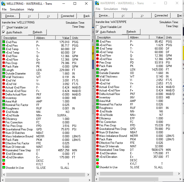
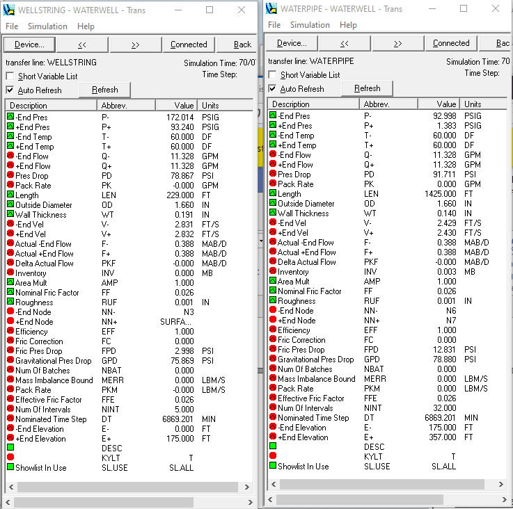
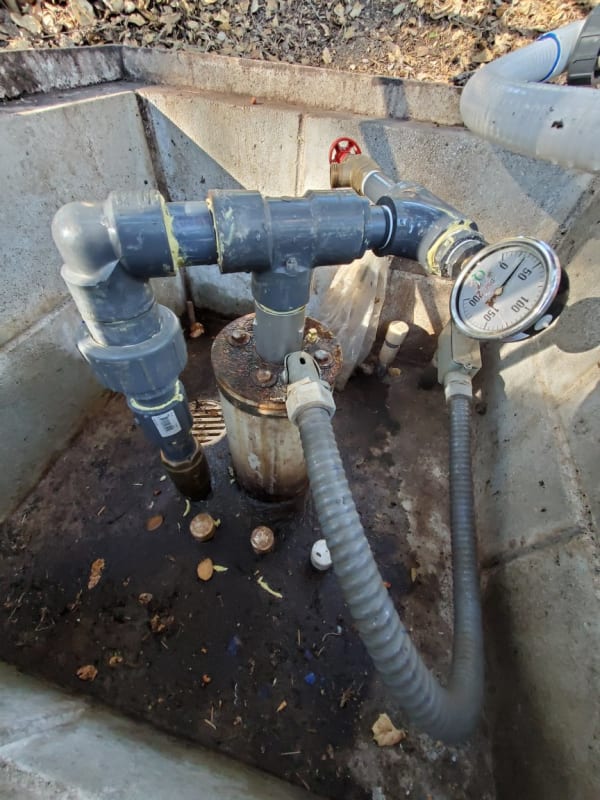
We pulled the pump and since the hassle was so great replaced the entire pump and riser using sch80 threaded riser pipe and SS female/female couplings. The new pump was a Berkeley pump identical to the original Gould that came out.

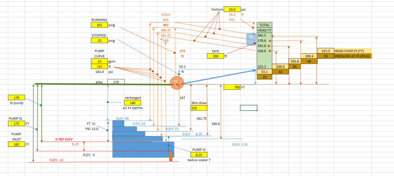
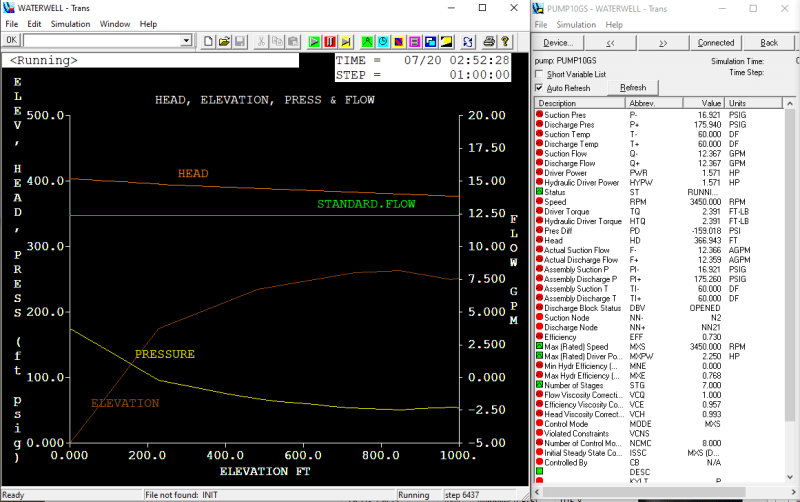
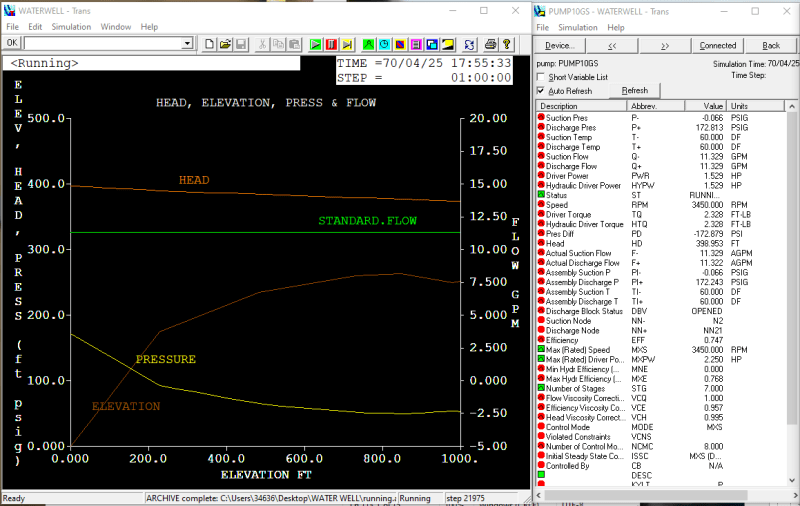
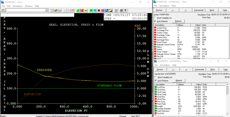
It pumps the same 15gal/minute into the same 230 feet of dynamic head.

The problem is that instead of being dead silent at the well head like the typical well I'm greeted with the sound in the clip provided below. I'm pretty sure it's the check valve fluttering. Why?!? Why now? How do I stop it?

Do note that my camera greatly exaggerates the actual sound level of The Noise. The correct level is what you'd hear if you turned down your PC's sound to the lowest level that you can still detect the noise.

Well Head Noise Video

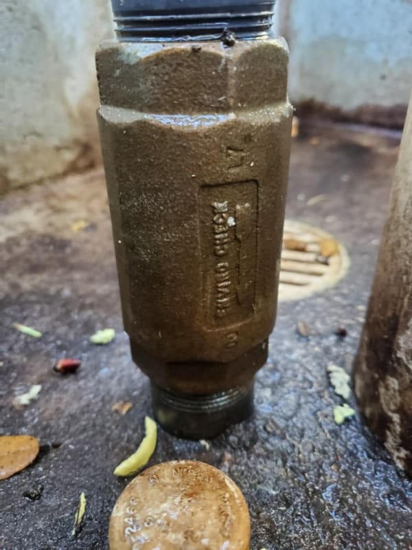
This is the checkvalve.

Check_valve_ri9vj1.jpg


Keith Cress
kcress -
 
Replies continue below

Recommended for you

Haha BI! We keep cross posting.

Water hammer... Recall I had that gauge on the well head? I got several opportunities to be staring at it from a foot away when the well was started. It would be at 26psi pump off and jump to 145psi about about 750ms after power arrived then rebound as fast as the needle could move to about 70psi then rise over about 500ms to 99.5psi where it stayed while the pump was on. It drops to 26psi over the time it would take the pump to decelerate to a stop, ~500ms.

Keith Cress
kcress -
 
No. Sorry. The diameter of the bore hole and well casing. 30ft of 4" diameter only contains 20gal, so without recharge, that would be a 1.5min run time at 12.5gpm. 6" has 43gal = 3.5min. There must a regular u/g river down there.

Statements above are the result of works performed solely by my AI providers.
I take no responsibility for any damages or injuries of any kind that may result.
 
Well casing 6".

We ran it out on the ground thru a 3/4" hose bib for an hour after shocking the well. No issue.

To get a permit to build a house your well needs to deliver 4,320 gallons in 24 hours or less.


Keith Cress
kcress -
 
I've been doodling around with your system there.
Here's a nice picture of the system, as much as I can imagine.

Keith_Well_System_r86wkx.png


Mostly according to what you said, which I have distilled down to the following in the quote box. It would be great if you'd have a second look. There were a lot of water table depths mentioned as well as pump depths.
I'm not totally sure about some, as pump is 8.25ft below water, but which water table level was that. Water table depths are actually more important than pump depths. Head delivered by pump is measured from the water table, so there are a bunch of total head elevations when the pump is running and pumping from different water table depths.

The 23 psig valve reading is interesting, because that would indicate that the tank is only 53 feet higher than the gage, yet you have said it is appx. 200 ft up and 700 feet away (but terrain was difficult to gage). Was that happening when the broken check was there? If so. what does it read now when the pump is off? If the line is full from well head to the tank, the PI should read Height_above_PI_feet x 0.4333 , maybe now around 90psig??? If it is not reading 0.43 * height_ft, there could be a pipe leak.

Keith said:
"1.5 hp pump 170 ft down"
"Sch 80 riser"
"Berkeley pump"
"Pumps same 15gpm into 230ft dynamic head"
"Flowrate is 12gpm"
"There is a gate valve at the tank sump"

Pump curve
D MODEL10GS15 HEAD 7 /* 4 IN 1.5 HP 15GPM
560 550 440 380 350 310 240 /* FT
0 5 10 12 13 15 16 /* GPM

"Water Table is 140 ft below wellhead" <<<<<<<<<<<<<
"8000 gal tank"
"Pressure gage reads 101psig when flowing"
"Pressure gage reads 23psig when not flowing"
"17 stage centrifugal"
"Draws 10.8A FLA is 11A"

START UP: "Pressure runs up to 130, falls to 85 then steady at 101. All in 2 seconds."

SHUT OFF: "Pressure falls to 25 psig instantly".
"A built-in check valve at top of pump at the bottom of well exactly 180 ft down."

CONTROL RESPONSE
"Choked the flow down until (well)head pressure went from 99 to 102.
Turned the valve wrong way (closing it) and pressure spiked at 150."

1-1/4 pipe sch40 horizontal 700ft and 200ft high

Pump inlet is 182 ft from casing top.
Recharged well is 140 ft below casing top.
30min draw drops to about 155ft.
4.5 min to fill the pipeline to the tank

WATER HAMMER

OFF 26 psig
START
0.75s = 145 psig
0.76s = 75 psig
1.20s = 100 psig

STOP
0.5s 26 psig

6" well casing

THANKS KEITH

Statements above are the result of works performed solely by my AI providers.
I take no responsibility for any damages or injuries of any kind that may result.
 
Very interesting..!

This got me looking at things and talking to a utility engineer who specializes in well systems. He told me he uses Google Earth all the time to do work-ups. He's stopped bothering to tape-measure things because of GE'th great accuracy. He's especially impressed by the vertical accuracy. He explained that he can put the cursor on the ground tanks are on and then move to the top of the tank with the cursor and it's always within a foot of the tank's actual height.

The lateral distances seem to be spot-on.

So going with that lets see how reality stacks up to my feeble estimates.

Well_Fix_zdh6wi.jpg


So distance is: 446m x 3.28084ft/m = 1,463ft
Only off by 2x!!


Height is:
Elevation_Near_well-head_srpfzq.jpg


So that's 389m except the well head is under trees and up 4 meters from that spot in the road. So the well head is
389m + 4m = 393m (Note: the value on the screen is wrong by the time I've captured the screen shot! It reads 389 NOT 398.)
393m x 3.28084ft/m = 1,289ft

Elevation_base_of_tank_wbdpgv.jpg

450.0m x 3.28084ft/m = 1,476ft

So the elevation difference is:
1,476ft - 1,289ft = 187ft

Summing it up:
Lateral distance: 1,463ft
Elevation difference: 187ft
Tank inlet is 10ft above tank base.

I deleted the gauge with all the plumbing hassles noted above so I don't know the off pressure now. :/
I took the difference in on/off pressure to be because the water at where the gauge was is trapped between (2) check valves. The fluttering one and the one in the well pump. All that's needed is the two to close at different times or rates to give an odd intermediate static pressure. There is no question the fluttering one did shut absolutely leaklessly. Because I had it's inlet side unplumbed many times. The off pressure never budged so I don't see how there could've been a pipe leak like in the riser.


Keith Cress
kcress -
 
Super. That's what I needed. I was going to suggest GE elevations. They are pretty accurate in general. They are taken on a 100m grid, so unless you have a vertical cliff, they work well. In fact sometimes the elevations can be more accurate than the photo placements. I've done preliminary hydraulics for a bunch of pipelines 100 to 2000km long with GE. I wish I had that back in the 80's.

I've got the tank at 205ft elevation now, so 20 ft lower is a smack on at double the length.

Yeah, its certainly possible the check wasn't sealing quickly and allowed some spillback.
Thanks.

You can pick off elevation profiles and set masurements for feet and miles if you want.
Keith_Water_Well_qbivqu.png


Statements above are the result of works performed solely by my AI providers.
I take no responsibility for any damages or injuries of any kind that may result.
 
With a long, long profile, you have to zoom in at various points alone it to tell GE that you want to have detailed elevations in that area. It can take a few minutes to gather all the elev data. It collects more detailed elev data based on the zoom view scale, just like the detail it shows in the picture tiles. But then don't zoom out too far or you can lose it.

Statements above are the result of works performed solely by my AI providers.
I take no responsibility for any damages or injuries of any kind that may result.
 
GE has made pipeline, road, power line routing work so easy in the concept phases it's untrue.

Compared to what we used back even as late as 2000 it is a huge step change

You can also get fly throughs.

I think the altitude figures come from the freely available digital data from the SRTM shuttle elevation which worked in squares of 90m. SO if you get a small hole or slit / canyon, you might not see it.

but I still find it amazing that this is all free to the user....

Remember - More details = better answers
Also: If you get a response it's polite to respond to it.
 
The original data was at 90m, but it was resampled and re-released at 30m 98ft. I seem to have confused ft and m ... again.

From JPL. Previously, SRTM data for regions outside the United States were sampled for public release at 3 arc-seconds, which is 1/1200th of a degree of latitude and longitude, or about 90 meters (295 feet). The new data have been released with a 1 arc-second, or about 30 meters (98 feet), sampling that reveals the full resolution of the original measurements.

I have a copy of the data and they mark the points that are bad with a "-1" instead of a real elevation. There are surprisingly few places so marked and they are always in very extreme topography, or sometimes are real -1 elevations on a beach at low tide. I was writing a program to return elevations, given a list of lat, long. I should finish that.

Statements above are the result of works performed solely by my AI providers.
I take no responsibility for any damages or injuries of any kind that may result.
 
Water table at 140ft depth...

RUN_WITH_WATER_AT_140_ft_depth_page_1_of_2_q43jfh.png


RUN_WITH_WATER_AT_140_ft_depth_page_2_of_2_ctevxz.png


Water table at pump inlet ...

RUN_WITH_WATER_AT_PUMP_INTAKE_page_1_of_2_vjnroj.png


RUN_WITH_WATER_AT_PUMP_INTAKE_page_2_of_2_wgvqfl.png


Statements above are the result of works performed solely by my AI providers.
I take no responsibility for any damages or injuries of any kind that may result.
 
Max pressure.

I can't bust this pipeline, even when closing an imaginary snap action valve in 1/16 of a second. Velocities are slow.

Worst max pressure case is a closed valve at the tank with the pump still running.
Best WAG is that the riser broke due to overloading for 5yrs and aging of the sch40 PCV. What is its max pressure rating? I did not look at that. 260 psig at bottom of riser here.
Check valve, don't know. Sand erosion? Corrosion. Fatigue?

I had a good exercise seeing how the program handled small bore pipe. I had to reconfigure a lot of data entry validation minimums and specify smaller default units.

Pmax_TK_CLOSED_PUMP_RUNS_bqw0zv.png


Statements above are the result of works performed solely by my AI providers.
I take no responsibility for any damages or injuries of any kind that may result.
 
Status
Not open for further replies.

Part and Inventory Search

Sponsor

Back
Top