Eng-Tips is the largest engineering community on the Internet

Intelligent Work Forums for Engineering Professionals

  • Congratulations waross on being selected by the Eng-Tips community for having the most helpful posts in the forums last week. Way to Go!

Oroville Dam Spillway Leaking (Again, 18 March 2019) As Waters Rise (Again) Behind Dam 27

Status
Not open for further replies.

racookpe1978

Nuclear
Feb 1, 2007
5,968
US
Complete failure at Oroville Dam
Original story and links at
| 3/18/2019 | by Chriss Street

Details at
Posted on 3/18/2019 at , 1:42:12 PM by rktman

From that story,
The $1.1 billion spent to repair Oroville Dam is failing as water is seeping through the rebuilt spillway threatens new mass evacuations over the risk of the dam collapsing.

According to national dam expert Scott Cahill of Watershed Services of Ohio, Oroville Dam is on the same failure track as in 2017, with visible water seepage trickling from the foot of the dam and dozens of points along the dam's principal spillway. Cahill warns that warming temperatures magnified by precipitation is a growing threat to the dam.

American Thinker reported on March 1 that the Sierra snow pack was at a record 113 inches, but another 44 inches fell in the next 10 days. With temperatures spiking this week to 75 degrees in the valleys and 41 degrees in the high mountains, dam inflows are running twice the outflows, and the water levels rose from 800 to 839 feet.
 
Replies continue below

Recommended for you

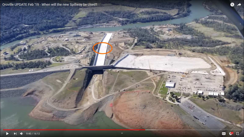
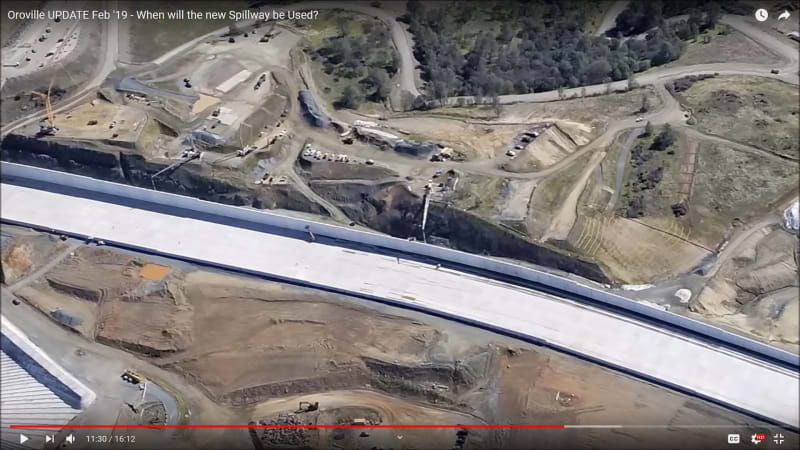
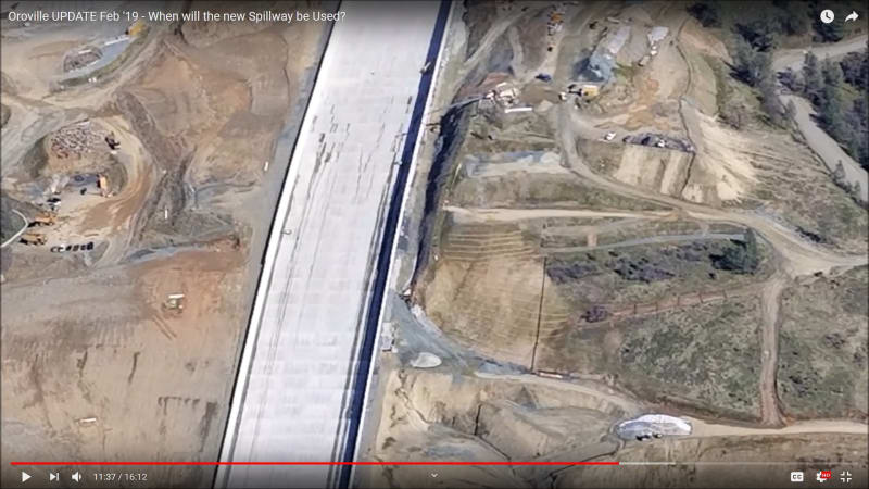
I'm not one to fuel conspiracies but..., these are screen grabs fro Juan Browne's Feb. 19 update. Keep in mind that in the week prior, the West Coast was hit by a Pineapple Express and some areas received up to 8 inches of rain.

Backfilling operations were in progress and you can see a man-lift inside the spillway at the same elevation as the water streaks.

1)
Oroville_1_Feb_19_a3a2a8.jpg


2)
Oroville_2_Feb_19_o2kuyc.jpg


3)
Oroville_3_Feb_19_uwie34.jpg
 
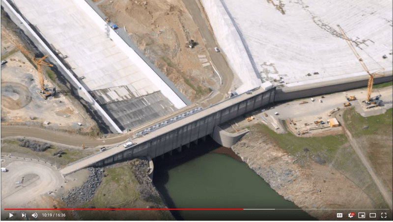
Here's a screenshot from the video that EdStainless posted on 19 March. It was taken by Juan Browne on 14 March and clearly shows that the water level in the reservoir had reached the front face of the spillway gates and it also shows that indeed there was leakage from those gates.

Screen_Shot_2019-03-25_at_1.24.23_PM_egduqu.png


John R. Baker, P.E. (ret)
EX-Product 'Evangelist'
Irvine, CA
Siemens PLM:
UG/NX Museum:

The secret of life is not finding someone to live with
It's finding someone you can't live without
 
epoxybot: There is water running down the spillway. It's been posted that the gates are leaking a nominal amount of water which runs down the spillway, most likely traveling along the surface in a serious of small channels from the expansion joints, and periodically expressing itself as streaks where the channels' capacity is exceeded and the water starts to run along the surface.

As I understand it, there are people who are claiming that is that the phreatic water from the upstream face of the dam is forcing water to seep through the embankment; then forcing its way through the drainage system under the spillway (which must be overwhelmed or has already failed in its entirety); then finally forcing its way through cracks in the concrete before trickling down the spillway. Is that even possible?

What is your theory about the streaks?

I happen to think they are the tears of an interplanetary guild of extraterrestrial engineers who traveled here seeking enlightenment but started crying when they read this thread [alien]
 
Let's assume that it is possible. Then, the water on the downstream side of the dam would then have to force its way through the concrete seam/seam stuffing, which requires a fair bit of pressure. With that pressure, one would expect the water to be spewing out under both edges of the spillway, yet there is none. Doesn't it seem odd that the engineers could be so lackadaisical to allow water leakage through the face of the spillway but not out the edges? Not to mention the fact that even without resistance, the water has to travel against gravity to get through the seam to the front side.

TTFN (ta ta for now)
I can do absolutely anything. I'm an expert! faq731-376 forum1529 Entire Forum list
 
What seems odd is that they'd spend millions of dollars to study the failure and it's shortcomings so they could replace the spillway properly only to then spend millions and millions of dollars more building a poorly built, improperly engineered structure that is destined to fail the first time water flows.

But then, I have yet to read a single theory how this water is forcing it's way through the spillway floor instead of flowing out of the massive new drainage system that was installed under the spillway.
 
What I posted earlier was a theory on how water MIGHT be hitting the underside of spillway. First post did NOT say it flowed thru and then down spillway, merely it might surface under it.
Guess that is not problem cause it has not been observed.

HAve gpr, grnd penetrating radar, probes of soils under spillway been done in lieu of piez. sensors?

With NO piez. it would seem prudent to have regularly scheduled GPR runs to highlite any voids before they grow large enough to be a huge problem.

With NO piezometers working, no one knows what is going on around dam. For 1B in funds WE could not find money to replace these critical sensors???.

The WET spot on dam has an elliptical centerline around 650 ft.

The initial spectacular hole/void failure of spillway seems to have occurred much lower in altitude. So they do NOT appear to be related. It appears to have occured right where some drainage flows of a road to the east (coming west vs over road and causing washout)
would have hit the spillway east side. NO 45 % intercept/diversion walls were built on east side of spillway to redirect hillside flows AWAY from spillway foundation and none seem to be part of new design.... or I just missed them....... IFT and pics inconclusive in this area.

BEFORE spending $1b to rebuild old design it would have been prudent to prove failure mode(s) and define wet spot issue. Safety of dam and downstream precluded such slow detailed effort.


The IFT report does NOT go into detailed analysis of groundwater. Just says that it was NOT a problem. Maybe they are right. But w/o needed sensors and their data,
we will never know.

Could the huge hole/void have removed the evidence of groundwater flows??

Communication is an imperfect art.. esp. as practiced by engrs.

Hope I have NOT missed the mark above...... if I have I am sorry.


@jcirish

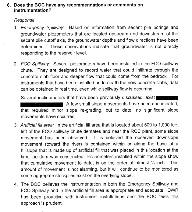
The Board of Consultants previously addressed the issue of piezometers in the spillway. Numerous ones were installed as part of the reconstruction:


(see excerpt below from page 9).

An independent board of consultants was engaged and has monitored every step taken during the recovery. There's lots of great detail in their reports:


See page 9:

Screen_Shot_2019-03-26_at_10.40.43_AM_z0dens.png
 
just found pic from 2013 of spillway... posted by cswilson on failures and disasters thread.
Shows 4 trucks on spillway at same spot where above pic in this thread has water starting to flow down spillway.

This is very near where huge spillway failure occurred. Do NOT think these pics are mere coincidence.

The flow from the upper gates at top does NOT go all the way down from top to here. Water appears to just come out of spillway in BOTH pics at almost same elevation.

In BOTH pics, yrs apart, it seems as if water is coming up from below spillway.....Know that is very difficult BUT
what other explanation is there? What is CAUSE of water flows in these 2 pics?????

I would think groundwater flows or phreatic flows could be source..... it has to come from somewhere.

And BELOW the impervious spillway there are NOT many possible sources.

 
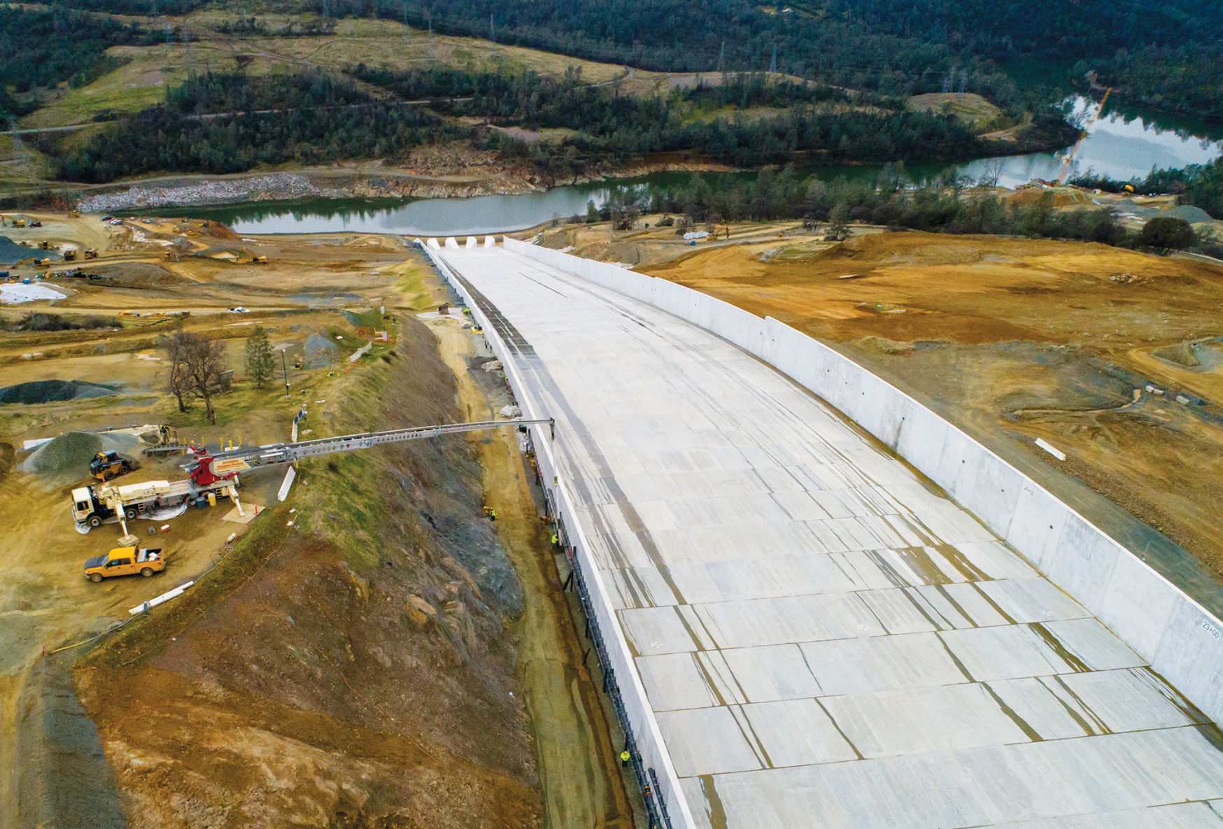
Here is a picture from earlier in the thread which shows pretty clearly how the water is flowing down the spillway from the gates.... then into horizontal expansion joints... then flowing down in a different location after traversing laterally across the joint.

5c6528b220bca.image.jpg

Full size:
The picture shows there are different preferential flow paths for small amounts of water to flow down the spillway. This is influenced by things like lateral and longitudinal slope, and expansion joint width. Even simple things like a piece of aggregate in the joint can influence where the water expresses itself on the surface of the spillway. Some areas are narrow concentrated flows of greater depth, where others are wider and more dispersed. None of this seems really unusual to me.

FACTS:
[ol 1]
[li]The spillway gates are not designed to be watertight;[/li]
[li]The spillway gates are under hydraulic head right now;[/li]
[li]The spillway gates are known to be leaking which provides a ready source of water at the top of the spillway;[/li]
[li]Water flows downhill;[/li]
[li]The water leaking from the spillway gates is flowing down the spillway.[/li]
[/ol]
CONCLUSION: The spillway is wet in places.

See page 136 of Design Standards No. 14: Appurtenant Structures for Dams from the U.S. Department of the Interior Bureau of Reclamation for a primer on the design of spillway drainage systems let us know how it is you think press water is traveling from beneath the spillway to above it.
 
great. that answers ALL my questions.. doubts. These flow paths were NOT visible in other pics.
 
Just read in NY doc on dams... that seepage often appears as spring.
Maybe that is the cause for the wet spot on dam downstream face to far right at ellipse centerline of about 650 ft.

If dam shows seepage... then same issue would be likely to present itself under spillway. Same designers, maintainers, like compaction process and materials (under the spillway.)

Could there be seepage that has not been found YET at spillway and or dam .....

It seems odd that after 1B in expense that wet spot cause can NOT be identified.

The earlier post on 400 ft deep hole during failure looks to be a width measurement. Depth in pic is more like 50 to 80 ft.

 
I'm not sure why the fascination re very minor surface expression of hydraulic flow. I have have absolutely zero practical experience with dams , but I have done a bit of underground grouting to withstand 200 metres hydraulic head. In good competant rock,say 60-100 metres below surface elevation, it is really interesting to watch as one area is grouted , the water then takes the next weakest path. This is in good rock ........ many of the photos of this area strongly suggest a prevalence of rotten rock. I am sure millions of $$$ were spent on grouting prior to pouring concrete , but if you really wanted totally dry conditions , I suspect youd be looking at billions for grout alone.

I am sure on going monitoring will easily identify areas that perhaps deserve more grout , and I dont see a problem pumping more cement into localized areas
 
@jcirish

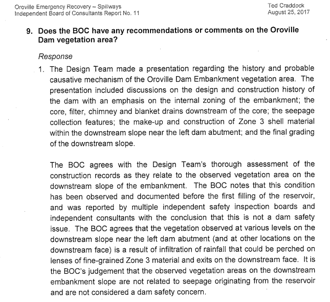
Not to sound like a broken record, but the Independent board of consultants ALSO addressed the issue of the "Green Spot", in the same report I linked you to earlier, see below.


Screen_Shot_2019-03-26_at_6.54.10_PM_kjnp3o.png


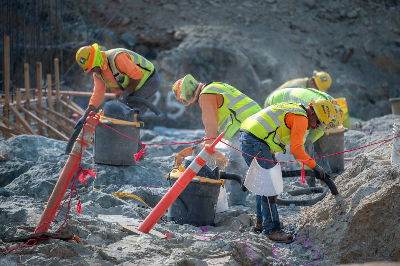
Further, the Dam is an earthen Dam, constructed in a 'valley' The spillway was constructed on the side of the hill adjacent. There is no 'compacted' material under the spillway, in fact, during the reconstruction they cleaned the foundations down to the bedrock by hand, with pressurized water, buckets and even shop vacs, see below for a picture from among 100's taken during the reconstruction.


FL_Oroville-0836_08_01_2018_l7dpq7.jpg
 
They started investigating the failure and planning repairs with on site work while the dam was still full, so how would they have missed a major seepage path that surfaced under the spillway?
 
Status
Not open for further replies.

Part and Inventory Search

Sponsor

Back
Top