Continue to Site

Eng-Tips is the largest engineering community on the Internet

Intelligent Work Forums for Engineering Professionals

  • Congratulations KootK on being selected by the Eng-Tips community for having the most helpful posts in the forums last week. Way to Go!

SF Tower settlement Part III 18

Status
Not open for further replies.

dik

Structural
Apr 13, 2001
25,672
thread815-412357
thread815-470048

Rather than think climate change and the corona virus as science, think of it as the wrath of God. Feel any better?

-Dik
 
Replies continue below

Recommended for you

I think Hamburger's credibility is seriously challenged. I've never been involved with this type of response. Seems like the Keystone Engineers... [ponder]

Rather than think climate change and the corona virus as science, think of it as the wrath of God. Do you feel any better?

-Dik
 
@pellucidar: It is tough to draw any conclusions from a week or two of data. The 1/10 inch drop in one week of the north-west corner was followed by a rebound the next week, then a very small drop, and then another big drop, so that the average rate of settlement of that corner remains about the same it has been since August. And they are just mucking around at the surface. They have not even begun construction of the new shoring walls (secant piles using CLSM with soldier piles every 5 feet) or the excavation down to 25 feet into the young Bay Mud layer! But the kink in the 1.2 inch settlement contour has straightened out. Maybe that was a survey error or a zombie trying to get out from under that mat? I dunno.
 
ti89t said:
Does the old/new PGE vaults referenced in your diagrams run the entire length of the cantilever slab?

Based on photos of the excavation, exposing the older utility vault, the older utility vault runs nearly the entire length of the 103ft width of the 3ft cantilever slab. The tower's vault is approximately 90ft long and 15ft wide. The soldier piles of the shoring wall, at 5ft o.c. seem to confirm the 15ft width of the old utility vault.

Unlike the north, west & east tower basement walls, which are shotcrete, the new PG&E vault is poured in place concrete. There is a small niche at on the exterior of the east end of the new PG&E vault that is a part of the Condo owners storage area. Neither PG&E or Mission Street Development appear to have traded any additional square feet and called it a day.

ti89t said:
Was the old PGE vault removed or just abandoned in place?

It remains to be revealed if the old PG&E vault was demolished or left in place. The last photo of the old PG&E utility vault, available on the Interweb, has a date of June 7, 2006. The pour for the mat was June 17, 2006. Neither the SF Dept. of Public Works (SFDPW) or the SF Public Utilities Commission (SFPUC), list permits for disconnecting PG&E Electrical, leading up to the tower's foundation pour.

I have made two separate PG&E Land Office requests regarding the current state of the old PG&E vault. With the first request, I received a phone call from Brad Harris of the PG&E Land Office. He wanted to more clearly understand my request. When I directed him to the Wikipedia page that showed the older utility vault, ...for some reason he dropped his phone and we lost contact...[surprise]. We reestablished contact and I was told he would dig into the matter. He was, he explained working from home but insisted, everything was at his fingertips (Covid Restrictions). 2 weeks later I left Brad a message following up. He promptly returned my call and said he couldn't find any record for a PG&E vault, buried under 129 Fremont St. I told Brad I has reviewed the Deed for 129 Fremont & the ALTA Survey and that I was unable to find any notation for the utility vault. He suggested that since the vault was on private property and not necessarily connected to 129 Fremont that there wasn't any need to file an Easement. Strange as it may seem, this could be true; as PG&E owned 129 Fremont at that time. The only useful information I was given was that PG&E sold 129 Fremont, May 2, 1972. Subsequent phone calls with Brad Harris, devolved into spin that the vault might belong to other utilities.

Later I contacted the PG&E Land Office regarding 345 Mission St. (SE corner lot of Mission & Fremont), to which PG&E began occupancy circa 1958. In this instance, I received an Email response, requesting further details. I was asking for the date of sale for 345 Mission, so I could request the deed from the SF Assessor. When I gave them a run down of my previous communications regarding 129 Fremont & Millennium Tower, I was told to go dig in the SF Assessors' archives. Finito [mad]

Twice now the PG&E vaults have escaped Environmental Impact Review (EIR). First in the original EIR for the tower's planning approval & secondly for the so-called Retrofit. The California PUC and the City & County of San Francisco afford Public Utilities relief from undergoing EIR under certain circumstances but in the instance of Millennium Tower, PG&E had zero NEED to relocate or refurbish the utility vault. The only reason for moving PG&E's utility vault was to accommodate a private developer and allow that developer to build on land that was under PG&E's control. The reason being that one cannot build on or over a PG&E Easement.

The problem with the newer PG&E vault built into the tower's basement, is that it is integral to the tower's basement, occupies a completely different portion of land (Vertically), cannot be located in the HOA covenants even though they share a common wall, while supporting the driveway and there are 3 transformers exiting the utility vault, into the basement of the HOA property. And finally for the Retrofit EIR, the utility vault has a multitude of cracks due to the tower's settlement, its robust construction results in additional stiffness to the cantilever slab and can thus be considered a factor contributing to the hinging of the cantilever mat and yielding of the rebar connecting the 3ft slab to the 10ft mat and perhaps the crack in the SE sloping SMRF. Just throwing gas on the fire, the newer PG&E vault sits about 25 feet from the Fire Emergency Water Reservoir located just south of the tower core. Granted, the reservoir is located in a particularly robust position of the mat.

Even if we were informed that the vault was demolished, the question lingers as to what extent it was demolished. Was the top of the vault demolished and the rubble placed in the bottom half?

ti89t said:
Is the old PGE vault pile supported?

I don't know. The top 11 to 17 feet bgs is liquefying sand fill. The Young Bay Mud in which it is embedded is marginally liquefiable. If the top of the old utility vault is -20ft sf datum and the overall height of the utility vault is 15ft, then the vault could be sitting on a layer of sand or more YBM. During ground clearing excavation, in advance of installing the CDSM shoring wall for the Transbay Transit Center, the subcontractor for Balfour Beatty Infrastructure, filed an RFI related to encountering piling that was supposed to have been cleared by the Demolition Contractor. The piles proximity to the tower was of a concern, since by the time the excavation work commenced the TJPA were paranoid about settlement on the Millennium Tower property. The response to the RFI noted a concern for the "utility vault" at -20 to -30 feet. These depths coincide with the older utility vault but there is enough ambiguity to the RFI, to not definitively know if the piles extracted were adjacent to, or below the utility vault. Somewhere at the TJPA and/or ARUP, there are photos.

ti89t said:
Do you have any plans/dimensions available?
I have attached a drawing giving the dimensions of the tower basement from which the size of the current PG&E vault can be extracted. The drawing is from one of LERA's submittals to SFDBI and can be found on LB Karp's "Millennium Debacle" webpage. I have been unable to access LB Karp's webpage recently. If you can't access the page, I can post the entire document..., once I find it in the maze of files I have accumulated.

ti89t said:
Do you have any construction sequencing documents for the MT?

No. I have a very long timeline that I have documented and cross-reference with what is available on line, gleaned from testimony and supplemented with observer accounts from the SkyscraperPage.com Millennium Tower Forum Thread. The forum thread include Webcor's Project Progress Press Releases.
 
 https://files.engineering.com/getfile.aspx?folder=753a4534-30e7-413f-8138-2f3fe79fd1d4&file=Tower_Footprint_15759_sq_ft_-_1.jpg
@epoxybot

You are an amazing individual and I cannot thank you enough for your work documenting this debacle.

I spoke with Larry this week about the website and he said his server is down but should be up in a few days. I’ve been using the waybackmachine to get archive copies of things until it’s back up.

I have some responses/follow up questions that I’ll send your way this week.

Thanks again!
 
Falsus in uno, falsus in omnibus

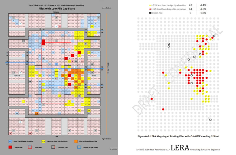
I was going through LERA's "301 Mission St. Stabilization - Structural Basis for Design" - Sep. 20, 2018, compliments of Larry Karp's Millennium Debacle page and came across a disturbing bit of information. Beginning on page 106, LERA gives the "As Built" description of the existing piles.

The piles Do Not conform to the Shop Drawings and description provided by Simpson, Gumptertz & Heger's, "Supplemental Report for Foundation Settlement Investigation"

How does this even pass the muster of the 301 Mission St. Dearly Departed Mayor Edwin Lee's Structural Safety Review Team? It seems that the entire report to the City of San Francisco was based on DeSimone Consulting Engineer's Design Drawings and NOT on what was actually built. San Francisco paid $150,000 for the report and seems to have been hoodwinked. Where was Craig Shields, the Geotechnical member of the Structural Safety Review Team?

Surely, if anyone had access to the As-Built drawings and RFI log, one would think it would be the Developer and their post-construction engineering team. There doesn't seem to be any comparison between the superiority of LERA's "Initial Work" and what SGH has served up. The HOA has made some very poor decisions.

Further into LERA's section on the existing piling, they produce a graphic that shows the locations of the short driven piles; not too different from the one I produced from the shop drawings. It would be interesting to know how Engeo Geotechnical Engineers described the ground and it's effect on the piles.

While I don't know when in 2018 LERA developed their 'short-driven' pile map. I'm going to gloat a little for having posted mine to Eng-Tips in early April of 2018, while their report is from Sep. 2018.

Cut-Off_Piles_z7c4p8.jpg
 
Mayor Lee had been dead 9 months by then. I don't think the review team was "his" anymore. Maybe throw in a "former" or something.

I get that there was a lot of sloppiness (at best) in the construction of this building. And the review of the construction of this building. And the design of the repair of the construction of this building. And the execution of the repair of the construction of this building. And the review of ALL of this.

THAT was fun to write. I was tempted to go on, but....

What are the implications of this particular form of sloppiness to the project?


spsalso


The implication of the sloppiness of the design, construction and review of the perimeter pile upgrade is that the real estate values will never be "restored", which, according to Hamburger in his university lectures, is the purpose of doing this "fix". Grade is F.
 
Oh, and I have heard one or more structural engineers complain that it has made geotechnical engineers in the Bay Area "more conservative". That might be true, but hopefully it has made them more careful rather than more conservative.
 
Walnuts said:
Oh, and I have heard one or more structural engineers complain that it has made geotechnical engineers in the Bay Area "more conservative". That might be true, but hopefully it has made them more careful rather than more conservative.
In reality it probably needs to be some of both. They obviously need to be more careful and make sure that their calculations are correct but they also need to be much more conservative and farther estimates go and they definitely need to err on the side of excessive safety. I'm sure the contractors and designers put a lot of pressure on them to reduce the costs but this is a perfect example of how the reduced costs come back to bite you in the long run!
 
"...the reduced costs come back to bite you in the long run!"

Exactly. The reduced costs will bite ME every time I cross the Bay Bridge:

Epoxybot, on this topic (Dec 4, 2020):

"...$1 dollar from every vehicle that crosses the SF-Oak Bay Bridge..."


Yes. Who reduced the costs? Who benefited from the reduced costs? And who are the "you"s that got bitten?


spsalso
 
I believe that the problem was driven by Millennium Partners desire to not increase costs but more than anything-else was driven by their desire to keep to a tight schedule, aided and abetted by Webcor. And aided and abetted by Treadwell & Rollo who relied on the "this is what everyone does" school of engineering when it was not applicable. The reason that you bear the cost is that the Transbay Joint Powers Authority was run by amateurs. Probably still is, although I have not followed that closely. But I believe they only put in $30 million to a $400 million settlement, so mostly it is the stockholders of a number of insurance companies that were taken for a ride by the lawyers and the legal process. "If you don't put up now, it will cost you even more if you go to trial." Maybe epoxybot can translate that to Latin for us?
 
ti89t - LERA's "301 Mission St. Stabilization - Structural Basis for Design" - Sep. 20, 2018, compliments of Larry Karp's Millennium Debacle page contains a couple of DeSimone drawings, namely the elevator pit, that makes this download of interest to your pursuit.

I'm going to throw SGH the mealy end of a dog bone over Ron Hamburger's Dec 2020 SEAONC Convention video and his remarks about the TJPA shoring wall restricting the settlement of the 3ft cantilever mat.

301_Mission_Foundation_-_October_17_2008_TJPA_Board_Presentation_kdjmcd.jpg


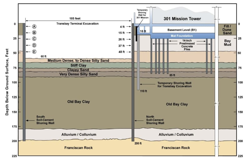
Reviewing this slide generated by Pelli-Clark-Pelli, shortly after the TJPA gained access to the Millennium Tower's drawings, one can see some pretty silly shoring ideas that would have put the TJPA directly in the bullseye. Presumably, they did not actually underpin the south end of the B1 basement with a 110ft deep shoring wall. Likewise. they did not sink the TJPA's excavation shoring walls to bedrock. The TJPA was required to provide Mission St. Development (MSD) with 'preliminary' and 'approved for construction' plans for work in the 5ft easement that MSD donated to the TJPA. So, SGH should know what is actually in the ground next to the B1 basement.

The turn around from when the TJPA was provided plans for Millennium Tower to when Pelli-Clark-Pelli gave the TJPA BOD a presentation was about 1 week, so the slide is somewhat back-of-the-napkin.
 
So the Transbay Joint Powers Authority can pass along their $30 million contribution because they can.

We will raise the bridge fare because cars are bad, and people who drive them are bad, and we will make them pay the extra dollar and no one will object. We certainly will not pay that $30 million out of our own pockets, because we have no pockets.

And the San Francisco Building Department. What are they kicking in? Are they raising permit fees to cover the expense?


spsalso
 
This whole thing just seems to get better and better.

Rather than think climate change and the corona virus as science, think of it as the wrath of God. Do you feel any better?

-Dik
 
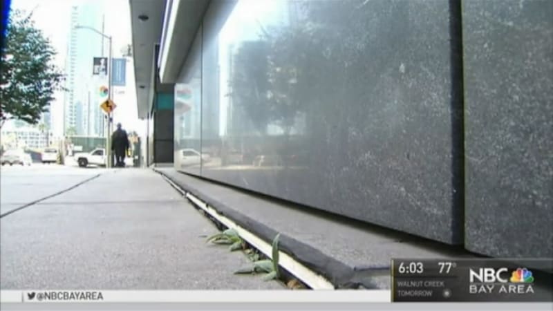
A recent report by NBC Bay Area’s Jaxon Vanderbeken has been getting some traction in the press. NBC’s report brings to the fore, the tower/podium shoring wall and the fact that the tower will most likely come to rest on the CDSM wall.

SF Gate later ran the story with commentary from SGH’s Ron Hamburger. Hamburger seeks to give assurances regarding the shoring wall, stating they have been aware of the shoring wall since 2014. No doubt this is true but more so, in relation to the leaking in the 5-level parking structure. It was, after all, LERA/Enego who felt it necessary to investigate the relationship between the tower and the shoring wall.

Compared to LERA’s permit submittal of just two locations of investigation, the actual scope of work was far more comprehensive. Still, it appears LERA missed the portion of the shoring wall that would have revealed just how much distance remains between the Tower/Podium shoring wall and the bottom of the 10ft mat foundation.

In SGH’s original 52 pile retrofit scheme, the Expert Design Review Team’s 2019 Final Comment Log, Comment 20, indicated the separation between the bottom of the mat foundation and the top of the shoring wall, noted by LERA/Enego, was approximately 2 inches. Considering the locations where LERA/Enego/ Nicholson Construction/Cotton-Shires Assoc., cored through the parking garage wall, to inspect the shoring wall/tower separation, there is no clear knowledge that the northern end of the shoring wall, at Mission Street, isn’t already in contact between the mat and the shoring wall.

While not a perfect analogy, SGH seems to be taking the ‘coaster under the table leg’ view of their repair scheme. What seems more likely is that the tower will settle to the east and come to rest on the northern stretch of the shoring wall before any settlement to the south can make any meaningful difference.

Since the tower’s foundation was mechanically connected to the shoring wall during the tower’s construction and it didn’t show any signs of settlement; SGH seems very optimistic that the shoring wall will indeed settle.

From the 13th floor to the 42nd floor, 56% of the building weight was incrementally added to the tower, at approximately 3 million pounds per floor, per week. When the tower was released from the shoring wall, tower settlement accelerated dramatically until the topping off ceremony.

The top of the shoring wall deserves some characterization. The wall has 34 each W24 soldier piles, in total, mostly spaced at 5ft on center. The final 30 feet of shoring wall at the north end has 6 soldier piles, spaced at 2.5ft on center. These soldier piles were subsequently cut down just above the Cement/Soil mixed wall. The tops of these soldier piles will be the first points of contact with the bottom of the foundation. This northern end of the shoring wall, is an area in the adjacent parking, subject to cracked walls and slabs with persistent water ingress. Since the tower won’t be coming to rest uniformly across the entire shoring wall, there is concern the soldier piles will chisel into the bottom of the tower's mat at a subterranean level; known to be well below historical ground water levels. According to ARUP’s Transbay Transit Center geotechnical investigation, the ground water of the former Yerba Buena Cove is brackish.

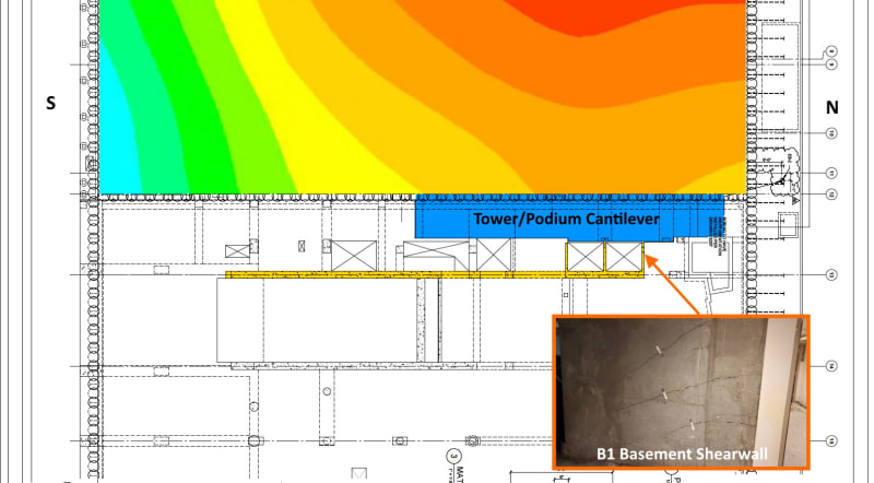
The following image shows the extent of LERA’s shoring wall investigation. The image requires some explanation. The base image provided the breadth of the site, with the shoring wall in yellow and the tower’s ground floor cantilever in blue. LERA’s investigation (Light Blue Overlay) is scaled to the base image shoring wall to highlight the extent of the shoring wall investigated. The lower overlay shows the 10ft mat and the original permit inspection points.

Tower_-_Podium_Shoring_Wall_Coring_-_3_urpyn4.jpg


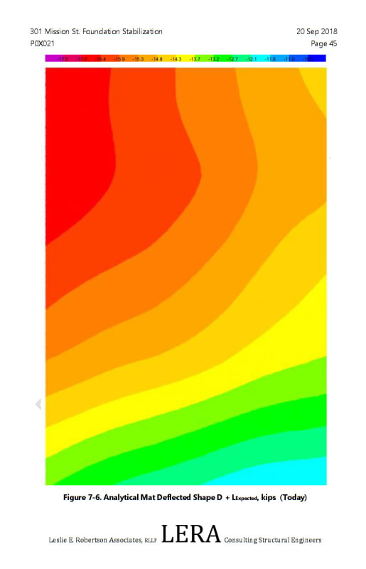
Page 45 of LERA's "301 Mission St. Stabilization - Structural Basis for Design" - Sep. 20, 2018 shows LERA’s Analytical Mat Deflected Shape, as of Sep 2018.

LERA_Mat_Deflection_sfmwk7.jpg


Scaling LERA’s Mat Deflection Map to the Tower/Podium shoring wall, it appears that LERA may have missed the portion of the shoring wall that represents the least separation between the tower’s mat and the tower/podium shoring wall.

Tower_-_Podium_Shoring_Wall_-_Down_Drag_of_Podium_f5leuy.jpg


In my April 18 2022 Eng-Tips post, I showed cracks in the Podium’s Elevator Shaft (Level B1) that is integral to the 5-Level Parking Garage’s Shearwall. This is directly in relation to the area missed by LERA’s shoring wall inspection. While pure speculation, what appears to have happened, is the Podium/Garage has suffered Shadow-Effect Down-Drag, resulting in the cracks seen in the elevator shaft.

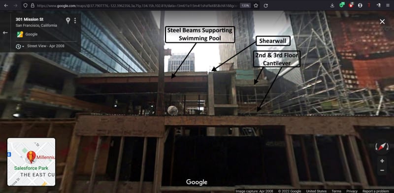
With the tower in its current state of tilt, the tower’s cantilever decks that projects into the podium, should be moving away (West), from the podium’s elevator door opening.

Tower_Cantilever-2008-4_zopujf.jpg


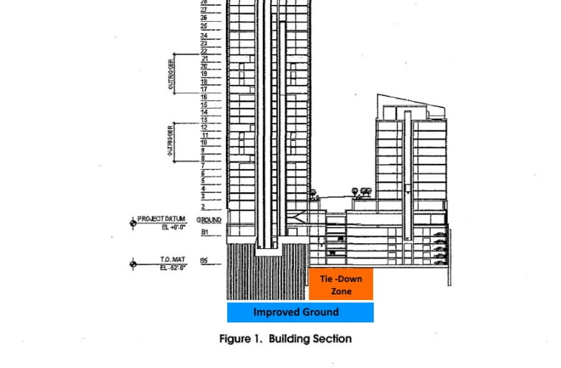
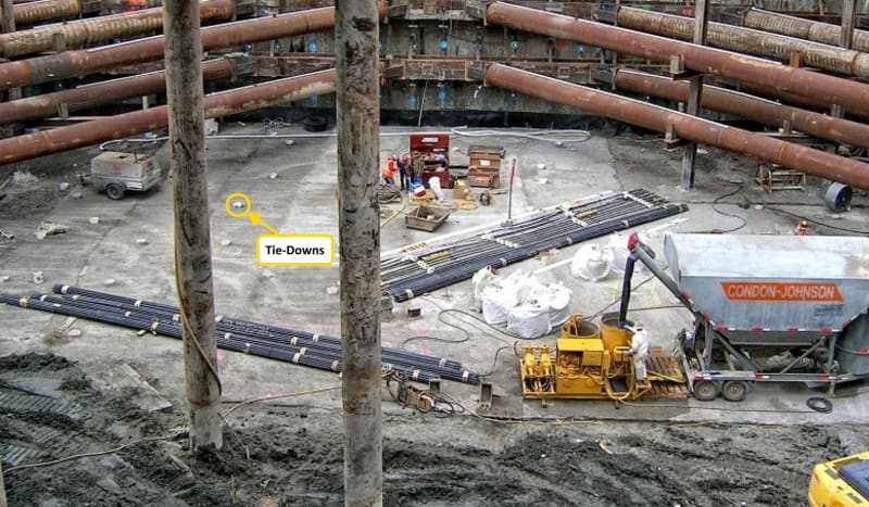
Remember that the Podium is buoyant and the 6ft thick portion of the podium/mid-rise mat, between the tower and the mid-rise is secured to ground with tie-downs.

Tie-Down_Zone_eozpac.jpg


Tie_Downs_ghxog4.jpg


Perhaps this explains why there appears to be uplift of the Mid-rise at the northeast corner of the Mid-rise at Mission & Beale. So, not so much basal heave as thrusting of the 6ft Mid-rise/Podium Mat.

10_xx3tbz_vx78kh.jpg


I don’t recall if the EDRT has concerned themselves with the seismic gap between the cantilever decks and the podium. Or, how much the gap will close as the tower settles to the east.
 
How will the existing piles interfere with the new proposed ones? Will they be able to jack against the new ones as proposed? Has there been any thought of getting a 'bunch' of geotekkies together to come up with a plausible solution?

Rather than think climate change and the corona virus as science, think of it as the wrath of God. Do you feel any better?

-Dik
 
Status
Not open for further replies.

Part and Inventory Search

Sponsor