Continue to Site

Eng-Tips is the largest engineering community on the Internet

Intelligent Work Forums for Engineering Professionals

  • Congratulations waross on being selected by the Eng-Tips community for having the most helpful posts in the forums last week. Way to Go!

Dam Failures in Derna, Libya 25

Status
Not open for further replies.
Replies continue below

Recommended for you

Brian
Underdesign of a dam above the city is a certain death trap. Nobody would build it.
I do not intend to convince you of anything. You must draw your own conclusions.

HERE IS WHAT YOU ASKED FOR
The EuMedClim Database: Yearly Climate Data (1901–2014)
of 1 km Resolution Grids for Europe and the Mediterranean Basin

Finding the data from 2014 to now should be the easy part.

CLICK ON THIS LINK TO DOWNLOAD FULL DATA SET
FILE SIZE:573.6 GB I ran out of space on my micro drive at 2.22GB and had to cancel.
Talk about overtopping! I'll have to buy a TB drive just for this one file.

--Einstein gave the same test to students every year. When asked why he would do something like that, "Because the answers had changed."
 
1503-44 thanks I will give a look at the data to see if there is specific enough info for Derna and its region in 1941 1956, and 1958.

I don't agree with your assumption an undersized dam would not be built upstream of a population center. Dams are built to the funding allocated and the directives of the entity with the most political power at the time of construction. There are plenty of examples of inadequate dams being built and failing. Even those that seem to be at the vanguard of technology can make mistakes. The inadequate earthen hillside emergency spillway of the Oroville Dam is a prime example:


In hindsight people were surprised the dam's emergency spillway was flowing down the earthen hillside and threatening to destabilize the dam. The engineers who designed Oroville dam were well respected.
 
we are trying to equate western principles to a third world country.

I might add during the Libyan conflict the military forces were told to keep the hell away from those dams and the post conflict teams to have nothing to do with them. And that's from UK sappers.

There has been very little support since ghaddifi left power. Basically all pretence of first world engineering stopped after lochobie.
 
Amen, Alistair. Was just about to post something similar. All this babbling on about the dams as if they were in a western country with a functioning government is just useless. Go read the NYTimes article I posted above; it was well known that the dams were in poor condition.
 
I'm not talking about the condition of the dams. Condition is not relevant to rainfall rates having changed, or not.

The dams were designed well before Lochobie.

I also don't see Oroville as having any relation. Dams fail for many reasons. Oroville failure did not involve excessive rainfall. The spillway failed due to a number of causes. Miscalculation of rainfall rates and storage volumes was not mentioned in that investigation, There is far more information on that subject right here on ET


--Einstein gave the same test to students every year. When asked why he would do something like that, "Because the answers had changed."
 
Lockerbie.

"In February 2017, heavy rainfall damaged Oroville Dam's main and emergency spillways, prompting the evacuation of more than 180,000 people living downstream along the Feather River and the relocation of a fish hatchery."
The main spillway was unable to handle the amount overflow from the heavy rain.

Regardless of implementation problems, the presence of two overflow spillways was insufficient at Oroville and blaming the lack for this disaster boils down to blaming the residents for their poverty (and for not living elsewhere) when the first world chose not to spend their wealth on their own dam which was close to a similar failure from a less intense increase over normal rainfall.
 
There is a bit of politics and ideology seeping through here... To be honest I have little knowledge about the climate of the region, though as I did point out that basic topology observation and understanding of a desert canyon environment does point towards extreme long tail events regardless of other made made climate change factors. On the other side of things, the warmth of the extreme Mediterranean this year cannot be ignored.

We are engineers, in our profession we should be agnostic towards the politics of the climate change politics. In my home country Australia, we introduced an explicit factor in our wind code for cyclonic regions to account for the changing climate. Right now that factor is 1.0. But it was deliberately introduced acknowledging the currently quantifying increased risk.
 
...a slight issue. Engineers should never be agnostic about anything. True agnosticism stipulates that the 'truth' will never be revealed. [pipe]

-----*****-----
So strange to see the singularity approaching while the entire planet is rapidly turning into a hellscape. -John Coates

-Dik
 

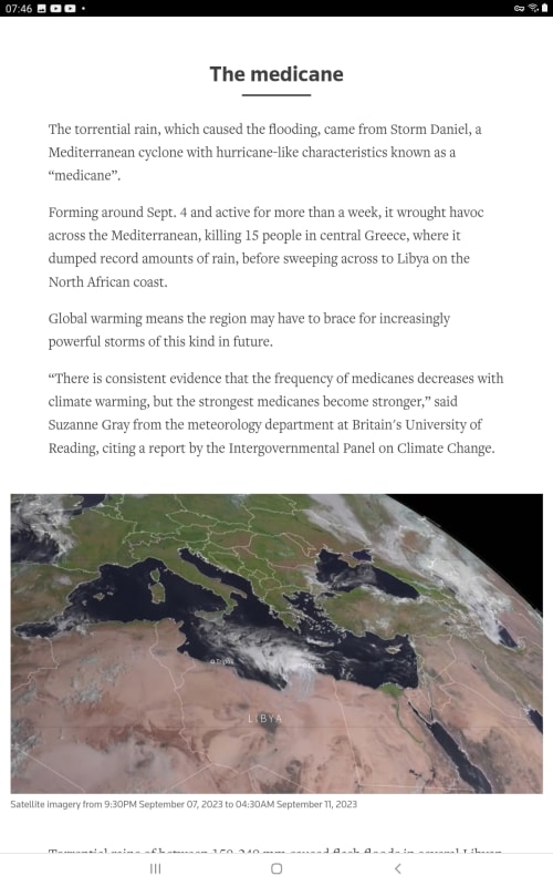
Screenshot_20230918-074617_Brave_yhxzzc.jpg


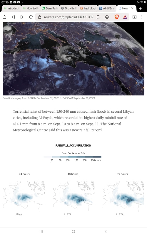
Can we stop arguing about whether the weather set new rainfall records.
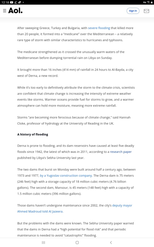
It says it did here. 414mm/24h
Unfortunately 24h is often the best available resolution and we don't get hard evidence of maximum rainfall intensities over shorter durations.


Screenshot_20230918-073619_Brave_fxvk58.jpg


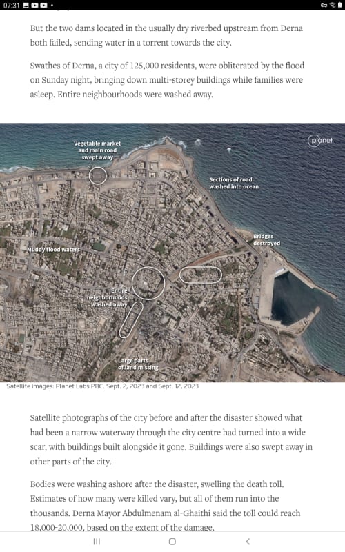
Screenshot_20230918-073200_Brave_qgnsfx.jpg


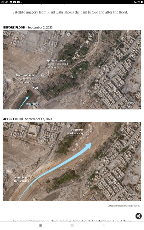
Screenshot_20230918-074602_Brave_gj3na5.jpg


--Einstein gave the same test to students every year. When asked why he would do something like that, "Because the answers had changed."
 
1503-44 said:
Underdesign of a dam above the city is a certain death trap. Nobody would build it.

My point about Oroville Dam is not about miscalculation of rainfall - it is about design mistakes can be made. The emergency spillway per the original 1968 design was inadequate to prevent erosion due to the very waterflow it was intended to carry and the design was done and reviewed by many capable minds. And the dam was built with an underdesigned critical feature upstream of major areas of population. My statement was and is: mistakes can be made.

Original emergency spillway:

New improved emergency spillway:

The dam operators had to make very difficult decisions when the limitations of the emergency spillway became apparent and the realization was made the design was inadequate from day one but it had never been used before. The belief was it would never be needed - the main spillway and powerhouse channels would always suffice.

It is apparent the rebuilt e-spillway addresses the issue of hillside protection as the original should have.
 
Hi Brian. Yes I understood your point was to explain there were other causes at Oroville. What I want to do is emphasise that I take the root cause of failure of the Derna dams as an extreme weather event that caused an overload on the dam. Whether the dams actually failed because of pressure from too high a water level, tunnel erosion at the dams base, a geologic fault, spillway overflow-erosion-destruction event, a construction defect, or maintenance issues is not important in the context of whatever broke the camels back was initiated by the extreme weather event.

What I am getting at is ...

If it didn't rain 414mm in 24 hours, none of this would have happened at all. In that context, was not the dam's failure sequence initiated by the extreme weather event? In that sense, weather would be the root cause of this failure.

If the dams were in perfect condition, so much water running through them could have overloaded the spillway, increased the base pressure too high, or tunnel eroded under the dams base, or manifested in failure from any number of reasons, but it was the weather that initiated the path to eventual failure. Given the record rainfalls in the area, I contend weather could have been enough to cause severe overload on any one or more of the dams systems resulting in total failure. Weather started it all.

--Einstein gave the same test to students every year. When asked why he would do something like that, "Because the answers had changed."
 
Got it! A lot of water did fall in a short time! No rain, no flood, no failure.
 
I've gone to the NOAA Precipitation rate data site above where I have collected the data tables on rainfall intensities for 5 US cities on the East Coast, areas subject to high intensity storms. Galveston, Tx, New Orleans, Orlando, Fl, Charleston SC, and NYC. I have Normalized all time-intensity values to the 24h rainfall intensity figures, creating factors for each time-intensity value for all cities. The normalised factors are remarkably similar.

If I assume that these intensities are valid for medicane storms, yeah, it might be a stretch, but I did it anyway, I maybe can get an idea of rainfall-time intensities of medicanes.

What it looks like is that in all those cities time intensities, and using the Derna value for 24h intensity of 414mm, then applying them to the 575km2 area of Derna drainage basin, they all result in roughly 30M m3 of rainfall in being generated in only a 5 minute storm duration.

I need to take runoff into consideration and find the potential volume of water reaching the dams for various concentration and storm duration times, but what it looks like so far is that medicane rainfalls are very capable of overwhelming any dam in its path, maybe within a few hours, IF the dams storage volumes and spillways were designed using the lighter rainfall intensities of the region based on previous rainfall records. 100mm rain on this basin generates a volume of 50Mm3. Accumulated rainfall is seen to possibly have reached 300mm+. That would surely have whipped these dams out regardless of any typical spillway protecting them. If so, there looks to be little likelihood that any dam in this region can survive such extreme events. If these become common occurrences, there's a lot of trouble ahead.

--Einstein gave the same test to students every year. When asked why he would do something like that, "Because the answers had changed."
 
LittleInch, I found another report on retention volumes, this one at 18 and 1.5Mm3

Screenshot_20230918-121854_Brave_ojkw3v.jpg


And this one with 22 and 1.5M.

And this guy says 18M looks high.

--Einstein gave the same test to students every year. When asked why he would do something like that, "Because the answers had changed."
 
Those figures are a bit better - I did a recalc on the top dam and now reckon its about 10-15 Mm3. But the dam wall is no way 75m.

not sure if that's what it was supposed to be as its in a wadi that is about 75 deep, but the dam itself is more like 30m max.

Either way, it was never going to hold back the deluge which arrived over the space of a few hours from its hinterland. you would have needed more than 10 of those similar ones all the way back.

They were simply a disaster waiting to happen and no maintenance was going to stop that volume of water.

The latest GE images have been updated and if you look at the damage on the river bank it shows that the wall of water was about 20m high coming out of the gorge by the lower dam. Everything under about 12m elevation looks to have been enundatede

Remember - More details = better answers
Also: If you get a response it's polite to respond to it.
 
Dam specs, from the builder.

Type of dam: Embankment dam with clay fill
Dam height: 75 m
Crest length: 300 m
Foundation width: 104 m
Embankment: 735.000 m3
Storage capacity: 18.000.000 m3

Type of dam: Embankment dam with clay fill
Dam height: 45 m
Crest length: 130 m
Embankment: 104.000 m3
Storage capacity: 1.500.000 m3
 
Well ... the one thing they all agree on is the top dam is 1.5 [ponder]
Confusing.

SSCon, Super thanks for the post.
I'll go with that.

--Einstein gave the same test to students every year. When asked why he would do something like that, "Because the answers had changed."
 
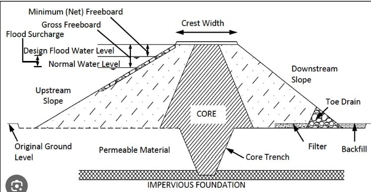
I've a feeling that when they say dam height they include the 15 to 20m that they dug into the wadi floor to get some anchorage / down to the impervious layer for the inner clay plug to prevent water leaking und it and de-stabilising it.

So a bit like this.
Screenshot_2023-09-18_160605_mnjy3o.jpg


There is no way those heights are height from bottom of the upstream side of the wadi / normal ground level to top of dam. However dam volumes seem about rightish based on the GE images and measurements.

So about 15 to 20 Mm3 for the upstream / higher up / southernmost dam and then about 1.5 to 2 M m3 for the downstream just above the city / lower down / northern one.

This is a picture of the lower one and shows with the scouring that the wall of water must have been truly biblical in its full flow at some 20m high torrent of water. You can see the trench they dug originally to seal the core of the dam.

Screenshot_2023-09-18_161158_wi20dq.jpg


Remember - More details = better answers
Also: If you get a response it's polite to respond to it.
 
Status
Not open for further replies.

Part and Inventory Search

Sponsor