Eng-Tips is the largest engineering community on the Internet

Intelligent Work Forums for Engineering Professionals

  • Congratulations waross on being selected by the Tek-Tips community for having the most helpful posts in the forums last week. Way to Go!

Potential Disaster in the Making 10

Status
Not open for further replies.

phamENG

Structural
Feb 6, 2015
7,212
0
36
US
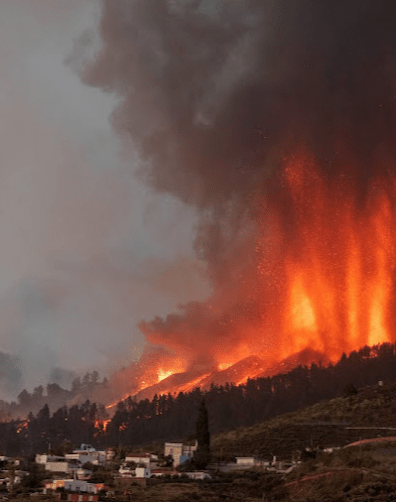
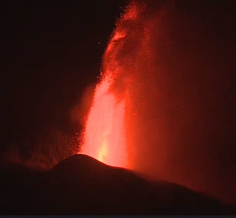
Cumbre Vieja, a volcano on La Palma in the Canaries, just erupted a couple of hours ago. National Geographic did an episode on it as part of a 'Disaster Earth' series a few years ago. Essentially, there's evidence of a massive landslide on the island a few hundred millennia ago, the likes of which would have formed a tsunami large enough to hit the east coast of the US. A recent earthquake seems to have restarted the process and formed a large fissure along the island.

Here's to hoping it doesn't move any more....
 
Replies continue below

Recommended for you

volcanologists here are calling those explosions mixing straight up flows of lava with air rather substantially as pyroclastic, as opposed to lava that more or less leaks out the side of a slope with little air mixing.

Guess I have to adjust my definition of 'pyroclastic flow'.

Any feel for how many homes have been toasted? Some of the pre-belligerence houses appeared to be sitting directly on prior flows but it's unclear if that's where these new flows are.

Good to see that any potential tsunami would only be 1/10th of a kilometer high.
43wqal5.gif


Keith Cress
kcress -
 
100 houses so far is all that they have reported in the news. I've been trying to find a flow map all day.
I can only find this probability plot. It seems to have covered most of the red tinted zones. There are really
lava_prob_overlay_ouyewd.png
a lot of houses and farms in there.

I've attached the Google Earth File of the map overlay picture.
Right click on "Lava Flow Probability" in the Places Box to the left and select "Properties" and then you can make scale adjustments and change the transparancy.

Yeah. 100m tsunami height ... just get out the Hawaian long board and turn up the music.
 
For what it's worth, this didn't come from facebook or any other social media for me (I swore those off years ago). My young son loves all things earthquakes and volcanoes, and at the age of three he could explain plate tectonics better than most high school students. Just so happens we'd watched the nat geo episode together a few weeks ago and I recognized the name of the volcano when I saw it in the news yesterday.
 
So about this landslide… how high do I have to go? Worst case vs. most probable?

Getting to anywhere during normal rush hour around here is a nonstarter. Let alone a panic.

The rich will all take to the skies. Is this something I can ride out in my kayak? Or should I be looking into a DIY sub to stay below the debris field?

What about a 5’ diameter watertight hamster ball of sorts(with air supply)? That would probably get buried below the all the debris. Not how I want to go.

Other ideas?
 
They used to go over Niagra in beer barrels. Wear your Go-cam.

It's not over till its over. Another fountain reported opening, with a 3.9 earthquake, that is expected to affect the Tacande area lava flows. New evacuations started in that area. They are saying it has completely unpredictable and could go on for weeks or months.

Now 20 KTn of SO2 gas has been released.

With the fan out of the lava and flatter slopes, the advance has slowed to 240m/h, so still has not reached the ocean. The lava is Aʻā type.
In contrast to Pāhoehoe, Aʻā lava has a very ough surface
Has a high volumetric and high velocity flow rate,
Has large flow channels,
Has thick flows (2-10 meters or 6-30 feet), 6m here.
Has higher viscosity, and is slightly cooler than other types..
A non-Newtonian, Bingham plastic type flow. Viscosity is not constant. The faster motion creates faster motion as viscosity reduces with increased rate of deformation. Hot ketchup.

Finally found a good map of the lava flows!
21 Sept 04:30h


EMSR546_AOI01_GRA_PRODUCT_6000_RTP02_r1_v1_thumbnail.jpg


PDF of that image file link.
 
Well apart for all the tragic it's quite spectacular and fascinating looking at it, mother nature at it's best and worse at the same time.
Maybe it's the same as with fireworks you can't stop watching because you never now what to expect and what will come next.

a_ooifte.jpg


/A

“Logic will get you from A to Z; imagination will get you everywhere.“
Albert Einstein
 
Lava 101
When lava has low viscosity, it can flow very easily over long distances. This creates the classic rivers of lava, with channels, puddles and fountains. You can also get bubbles of lava filled with volcanic gasses that burble and pop on the surface of the lava. And over time, volcanoes made from low lava viscosity are wide and have a shallow slope; these are known as shield volcanoes. Classic examples of shield volcanoes are Mauna Kea and Mauna Loa in Hawaii, as well as Olympus Mons on Mars.

When lava has a high viscosity, it’s very thick and doesn’t flow very well at all. Instead of rivers of lava, you can get crumbling piles of rock flowing down hill. It can also clog up the volcanic vent and form blocks that resist the flow of lava. Viscous lava will trap pockets of gas within the rock, and not let them pop as bubbles on the surface. But most importantly, highly viscous lava is associated with explosive eruptions and dangerous pyroclastic flows.

An example of a low viscosity (fast flowing) lava is basaltic lava. This flows quickly out of a volcano at a temperature of about 950 degrees Celsius. This flows out for great distances creating shield volcanoes or flood basalt fields. An example of high viscosity lava is felsic lava, like rhyolite or dacite. It erupts at lower temperatures, and can flow for tens of kilometers.
 
Thanks dik.

Tenerife (Mt Tiede 4817m msl) is higher than Everest when measured from the seafloor, as are a couple of the Hawaiians (taller still), so this lava is the thick stuff. I think we're the 3rd or 4th largest mountain in the world. The sea floor near La Palma is lower, as is its sumit, so actually both are really huge mountains.

Screenshot_20210918-064558_Firefox_xzh2bh.jpg


Screenshot_20210918-064548_Firefox_n0dhxg.jpg
 
Status
Not open for further replies.
Back
Top