Eng-Tips is the largest engineering community on the Internet

Intelligent Work Forums for Engineering Professionals

Oroville Dam Spillway Concrete Failure (Feather River Flooding, CA) 36

Status
Not open for further replies.

msquared48

Structural
Aug 7, 2007
14,745
0
0
US

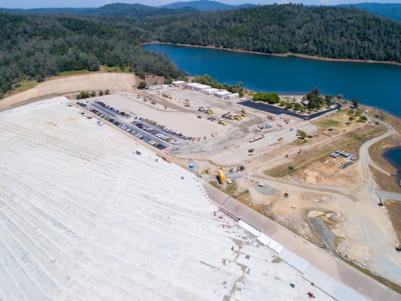
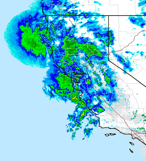
Erosion has created a 300-foot-deep hole in the concrete spillway of Oroville Dam and state officials say it will continue grow.
State engineers on Wednesday cautiously released water from Lake Oroville's damaged spillway as the reservoir level climbed amid a soaking of rain.

Situated in the western foothills of the Sierra, Lake Oroville is the second-largest manmade reservoir in California after Shasta....

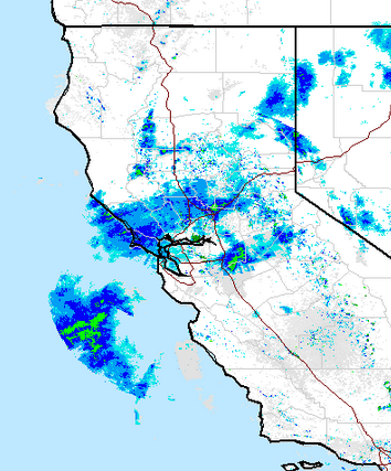
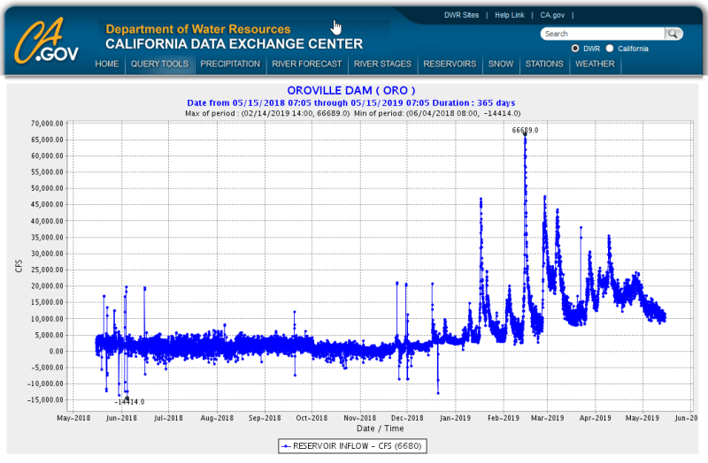
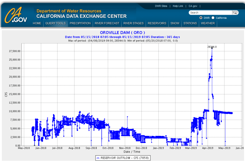
Member Spartan: Stage storage flow data here for those interested:

Mike McCann, PE, SE (WA)
 
Replies continue below

Recommended for you

DWR (State of Calif) has a financial interest to store as much water as possible in their reservoirs, both for water delivery contracts to downstream municipalities (sale generates cash) and for power generation (sale generates cash). As noted by Spartan and others above, high surface water elevations are the annual goal, and not a short term test, as attested by historical data.
 
The Lake Oroville level is approaching 11 feet of where it would start to flow over the emergency spillway, and it continues to rise at something like an inch or so per day, as shown on the website below. Granted, at that rate, it'll probably never reach anywhere near that level, but the reservoir is basically 'full-to-the-brim'.


John R. Baker, P.E. (ret)
EX-Product 'Evangelist'
Irvine, CA
Siemens PLM:
UG/NX Museum:

The secret of life is not finding someone to live with
It's finding someone you can't live without
 
You can see lots more data here:


While I'm no expert, I believe the 'TOC STO' field represents the target storage amount, which is now 'maxed out' but the lake is still 170K acre feet below this amount.
You can also see that the total inflows are decreasing and are only slightly higher than the outflows they are sending through the power plant.
As ATSE says, the goal of the operators is to try and fill it 'to the brim' but not over...
 
'TOC STO' means top of conservation storage. (I just looked it up)

"The top of conservation storage marks the bottom of the “flood storage.” Flood storage is the depth allocated to capture surplus water during intense rainfall events. Also, the bottom of conservation storage marks the top of the inactive storage pool—the lowest layer of water in the reservoir, designed for collecting sediment."

[URL unfurl="true"]https://balancingthebasin.armylive.dodlive.mil/2014/04/30/conservationstorage/[/url]

It's interesting how that TOC STO level moves up and down. Must be related to seasonal potential for large rainfall events?
 
Yea, it looks like some weather is moving in from the Pacific (see the screen grab below from the current radar weather map):

Screen_Shot_2019-05-14_at_7.08.11_PM_zty7xb.png


John R. Baker, P.E. (ret)
EX-Product 'Evangelist'
Irvine, CA
Siemens PLM:
UG/NX Museum:

The secret of life is not finding someone to live with
It's finding someone you can't live without
 
They have 170,000 Acre-feet of storage room 'left' in the Conservation pool. If you look at the rate of change in AF, you can see that even a month ago when the inflow was much higher, the reservoir was only gaining about 15-20K AF a day:


They could also use the FCO (spillway) again if they really need to. Perhaps the only issue might be that they are still working on repaving/rehabbing the boat ramp area, I'm not sure if this area is underwater if they reach the top of the Conservation pool:


KG_oroville_drone_23229_05_06_19_xnvkt9.jpg
 
But for the nutjobs stirring up anxiety in the community, this seems like much ado about nothing.

So far this season they've had a few spikes in the inflow of 40,000 CFS range with one burst at 67K CFS. They've tested the spillway at 28,000 CFS and by every indication it has passed with flying colors. It looks like for all intents and purposes that the system can handle whatever is thrown at it.

And even if there is some massive government coverup conspiracy i(involving every engineer on the project), we've seen what the worst case scenario looks like; the unzipping of the primary spillway down to bedrock.

inflow_np8dxp.png


outflow_pnmkvw.png
 
It appears to be raining in the Oroville area as seen both from the webcams and the weather radar (see the screen grab below from the current radar weather map):

Screen_Shot_2019-05-15_at_7.13.19_AM_uyp63w.png


John R. Baker, P.E. (ret)
EX-Product 'Evangelist'
Irvine, CA
Siemens PLM:
UG/NX Museum:

The secret of life is not finding someone to live with
It's finding someone you can't live without
 
BTW, this is all well and good as this is the water that we here in SoCal will be drinking NEXT year ;-)

John R. Baker, P.E. (ret)
EX-Product 'Evangelist'
Irvine, CA
Siemens PLM:
UG/NX Museum:

The secret of life is not finding someone to live with
It's finding someone you can't live without
 
There may have been rain to the east of Lake Oroville on Wednesday but by evening it was snowing in the Sierras and that continued trough Thursday. Here in the SF south bay on Wednesday the temperatures were mild until about 7pm, when a pounding squall came through and then the temperature dropped swiftly by about 10F to 15F. I don't think this storm excited the snow pack but we'll have to wait and see what the weekend storm is like.
 
In Juan Browne's video I posted earlier, he mentions that I-80 was forced to clos the night before for awhile due to snow in the mountains. He posted his video on Thursdays so that sounds about right. He mentioned that the rain on Thursday, which was falling while he was shooting his video, was very cold so he wasn't sure that it would contribute to much snow melt.

John R. Baker, P.E. (ret)
EX-Product 'Evangelist'
Irvine, CA
Siemens PLM:
UG/NX Museum:

The secret of life is not finding someone to live with
It's finding someone you can't live without
 
At 1600hrs on the 18th it's raining pretty good in the Top-of-the-Dam camera.

[ignore]
DATE/TIME PDT - RES ELE/FT STORAGE/AF OUTFLOW/CFS - INFLOW CFS - RIV REL/CFS RAIN INCHES
05/18/2019 05:00 890.95 3,396,595 11,942 11,914 9,487 44.04
05/18/2019 06:00 890.95 3,396,595 12,035 11,921 9,487 44.04
05/18/2019 07:00 890.95 3,396,595 12,009 11,927 9,512 44.04
05/18/2019 08:00 890.95 3,396,595 11,961 11,920 9,513 44.04
05/18/2019 09:00 890.95 3,396,595 12,000 11,917 9,513 44.04
05/18/2019 10:00 890.95 3,396,595 12,052 11,931 9,513 44.04
05/18/2019 11:00 890.95 3,396,595 11,927 11,942 9,513 44.04
05/18/2019 12:00 890.95 3,396,595 11,840 11,934 9,538 44.04
05/18/2019 13:00 890.94 3,396,442 12,024 11,934 9,513 44.04
05/18/2019 14:00 890.94 3,396,442 11,982 11,943 9,513 44.04
05/18/2019 15:00 890.94 3,396,442 11,969 11,930 9,513 44.05
05/18/2019 16:00 890.94 3,396,442 -- -- -- 44.11
[/ignore]
(Sorry the formatting doesn't work as it should)

10 feet below the E-spillway.


Anybody know what that wooden box like thing is a ways down the spillway?

Spillway_boxes_d7yuz7.png


Keith Cress
kcress -
 
As in Crane-in and out?

Anyone notice how it's actually crows that run the spillway gates? There is almost always at least one crow standing on some part of the gate actuators. One landed on the farthest box and turned 30 revolutions on it. Made me dizzy watching it.

Keith Cress
kcress -
 
Status
Not open for further replies.
Back
Top