Navigation
Install the app
How to install the app on iOS
Follow along with the video below to see how to install our site as a web app on your home screen.
Note: This feature may not be available in some browsers.
More options
Style variation
-
Congratulations cowski on being selected by the Eng-Tips community for having the most helpful posts in the forums last week. Way to Go!
You are using an out of date browser. It may not display this or other websites correctly.
You should upgrade or use an alternative browser.
You should upgrade or use an alternative browser.
Rapidan Dam - MN 1
- Thread starter azcats
- Start date
- Status
- Not open for further replies.
Murph 9000
Computer
Google Maps
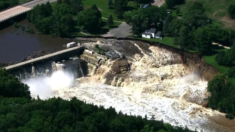
This looks to me like a failure in water level management. The dam seems to have a significant width of openable sluice gates which can maintain the level well below overtopping. For it to get to the point where it's high enough to start flowing around the western end of the dam structure, it says to me that the rising level has probably been ignored for quite some time, and this is a failure of management.

That's an interesting use of "diverted". It looks like the water made all the choices, and created its own new channel. If there's nothing to resist it, I can see that potentially continuing to erode until the dam has drained.
This looks to me like a failure in water level management. The dam seems to have a significant width of openable sluice gates which can maintain the level well below overtopping. For it to get to the point where it's high enough to start flowing around the western end of the dam structure, it says to me that the rising level has probably been ignored for quite some time, and this is a failure of management.
CBS / WCCO said:Part of the river has been diverted around the west side of the dam where water continues to flow, the sheriff's office says.

That's an interesting use of "diverted". It looks like the water made all the choices, and created its own new channel. If there's nothing to resist it, I can see that potentially continuing to erode until the dam has drained.
I imagine it is pretty hard to manage water level when you get 15" of rain. Not sure if this particular area got that much rain but a large swath between Sioux Falls, SD and Sioux City, IA got 12-15" of rain in a 3-day span. Large areas of Iowa and Minnesota had similar storms. Not really much opportunity to "manage water levels" with that type of event and those events don't lead to water levels rising over a long period of time.
Murph 9000
Computer
Well, I could be wrong, but it looks to me from the way the water is flowing through the dam and the debris is trapped behind it, that the sluice gates were closed before it overtopped. It might not be ideal for those downstream of the dam, but it seems to me that the gates should have been opened fully the moment there was both heavy rainfall and a high water level. If the rain was at all predictable, the water level should have been maintained at a lower level to provide some flood control capacity. The Google Maps street view shows that the gates are pretty huge.
Murph 9000
Computer
Based on the Google Maps measuring tool, the 5 flood control sluices are 54m wide in total (including the piers separating them). I'd guesstimate the height when fully open at around 3m (the door on the hut leading out onto the platform for the 4 power plant intakes seems like the best reference). I'll defer to the fluid dynamicists, but that's fairly massive flow that can be drained without endangering the structure by allowing it to overtop the sides.
Murph 9000
Computer
Facts about the Rapidan Dam from the county, who seem to be the current owner/operator of the dam (based on some of the news reports).
SWComposites
Aerospace
per the USGS stream flow monitoring site, today's stream flow is 34300 ft3/s; pervious high recorded in the last 81 years was 15900 ft3/s. so they got hit with 2X flow rate vs previous high. yikes.
"In 2021, the county commissioned two studies to explore the options for addressing the dam’s state of disrepair — either dam repair or dam removal "
I imagine it is pretty hard to manage water level when you get 15" of rain. Not sure if this particular area got that much rain but a large swath between Sioux Falls, SD and Sioux City, IA got 12-15" of rain in a 3-day span. Large areas of Iowa and Minnesota had similar storms.
Did the forecasters make a mistake in predicting the rain fall amounts? I don't think that the rainfall would have been a surprise, so the usual suspect is to release water in advance of the storm, particularly if there's an obvious probability of overtopping.
TTFN (ta ta for now)
I can do absolutely anything. I'm an expert! faq731-376 forum1529 Entire Forum list
- Moderator
- #10
The situation was made worse by debris partially blocking the spillways.
--------------------
Ohm's law
Not just a good idea;
It's the LAW!
It looks as if an unintended consequence of delayed response to the studies was mother nature casting the overriding vote for dam removal."In 2021, the county commissioned two studies to explore the options for addressing the dam’s state of disrepair — either dam repair or dam removal "
--------------------
Ohm's law
Not just a good idea;
It's the LAW!
I think that the USGS gauge is not measuring the flow that's "been diverted around the west side of the dam".
The next gauge downstream at Mankato reads 91,000 ft3/s
Subtract out 20,400 ft3/s that the Le Sueur river is adding
and the Blue Earth river is about 70,600 ft3/s
That's more than double the design 100-year flood (100 year flood: 34,600 cubic feet per second)
And 164% of the Flood of record (43,100 cubic feet per second)
-
1
- #13
IRstuff I'm not sure if you are unfamiliar with the types of thunderstorms that are common in that area of the United States but they aren't exactly predictable. They can drop an inch of rain in one spot and 1 mile away may get nothing. They can be almost unbelievably isolated.
The amount of rain that fell in some of these areas in a large percentage (60-70%) of the yearly rainfall in the matter of a couple days. Even if the Ripidan Dam owners had a crystal ball to see this coming and had drained the lake the amount of water they are dealing with would have likely quickly filled the lake and overwhelmed the dam.
This weather event is likely well beyond even a 100 year event. It's devastating SD, IA, and MN.
Relevant video from drone:
While the flow over the spillways looks significant and there is some amount of blockage from the debris packed against the dam, it certainly doesn't look as if there would be any dam for that location that would do better.
While the flow over the spillways looks significant and there is some amount of blockage from the debris packed against the dam, it certainly doesn't look as if there would be any dam for that location that would do better.
mintjulep said:I think that the USGS gauge is not measuring the flow that's "been diverted around the west side of the dam".
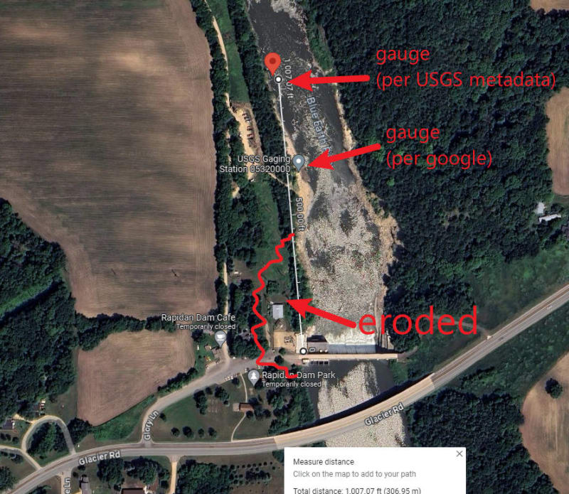
The stream gauge's stilling well seems to be located 650' to 1000' down stream of the dam, and is on the west bank of the river. This appears to be down river of the eroded bank (per most recent photo I've seen). If the stream gauge is still reporting readings then it is obviously not destroyed. So I'd wager that the gauge has been/still is capturing all of the "diverted" water also.

But now that I've looked at the graph a little more, something interesting pops out...
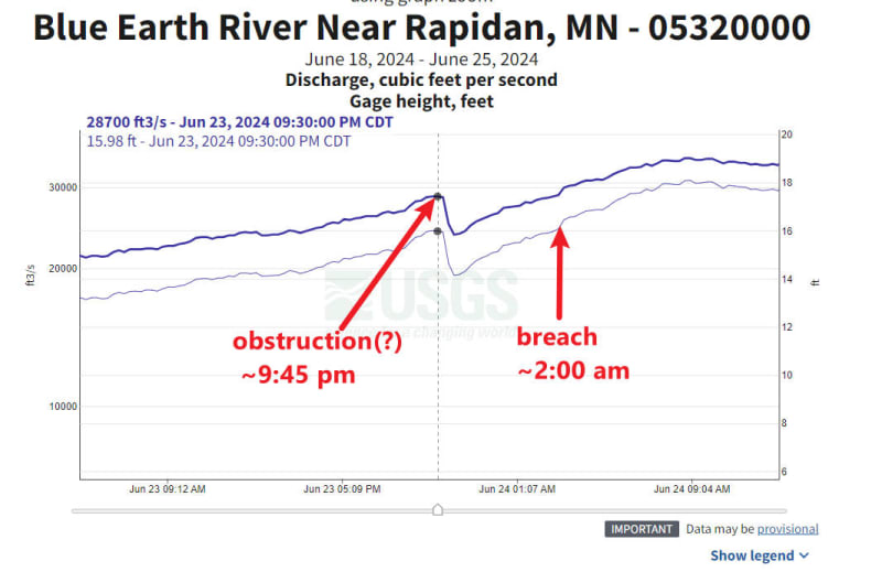
According to the reports, the 'breach' didn't occur until Monday morning 6/24/2024 approx 2:00AM CDT. (time according to a quote in this article: Link )
HOWEVER... there is a fairly large drop in stream flow (28,700 cfs down to 23,700 cfs) around 9:30PM-10:00PM CDT on Sunday 6/23/2024. I wonder if that was a bunch of debris clogging up the spillways? Or operators closing the gates?
Note this is the stream gauge immediately down stream of the dam:

According to the reports, the 'breach' didn't occur until Monday morning 6/24/2024 approx 2:00AM CDT. (time according to a quote in this article: Link )
Rapidan Dam Store owners via CBS said:RAPIDAN TOWNSHIP, Minn. — Jenny Barnes and her family have owned the Rapidan Dam Store for half a century. She often works through the night, baking pies.
Around 2 a.m. Monday, she heard loud bangs, saw flashes of light and knew the river was getting too close for comfort.
"The water is re-routing and it's re-routing towards our house — my dad's house. He's lived there over 50 years," Barnes said.
HOWEVER... there is a fairly large drop in stream flow (28,700 cfs down to 23,700 cfs) around 9:30PM-10:00PM CDT on Sunday 6/23/2024. I wonder if that was a bunch of debris clogging up the spillways? Or operators closing the gates?
Note this is the stream gauge immediately down stream of the dam:

Murph 9000
Computer
3DDave said:While the flow over the spillways looks significant and there is some amount of blockage from the debris packed against the dam, it certainly doesn't look as if there would be any dam for that location that would do better.
The original, as-built dam would possibly have performed better. See section 2.2.2 "Spillways" in the November 2021 repair feasibility study that you linked above. In addition to the current five 33' x 10' tainter gates, there were an additional two gate bays to the east of them with "timber needle gates" which were removed and permanently sealed with concrete in 2017. The current dam was operating with approximately 71.4% of its original spillway gate capacity. Additionally, they sealed off four 5' x 7' (approximate) sluice tunnels under the spillway, further reducing the maximum sluice capacity.
In the powerhouse, only two of the 4 bays were in use, possibly also reducing the maximum flow a little. This isn't certain, as the powerhouse was significantly changed from the original design, so the two active bays might have a higher flow than the original design.
Heaviside1925
Mechanical
To MintJulip's point, I am suspect of the gauging station's accuracy. I would assume there is calibration factor based on an assumed width. Since this flow was so extreme, the assumed width factor may be way off resulting in a lower flow rate be recorded, whereas the station farther downstream the actual flow would be a more accurate representation.
Additional thought. if the gravity head is being determined by a bubbler, there could be enough turbulent flow and entrained air to make the gauging inaccurate.
Additional thought. if the gravity head is being determined by a bubbler, there could be enough turbulent flow and entrained air to make the gauging inaccurate.
The owners of the house and business have now seen the last of it go. Per the linked, the county bought the property and remaining business building and have torn down the building to eliminate the chance of becoming debris if the erosion continues. House movers declined the job of relocating it.
- Status
- Not open for further replies.
Similar threads
- Locked
- News
- Replies
- 2
- Views
- 822
- Replies
- 2
- Views
- 499
- Replies
- 139
- Views
- 5K
- Replies
- 27
- Views
- 925
- Locked
- Question
- Replies
- 11
- Views
- 684
