apper.42 said:
22" sounds like a lot but it is sort of diagonal to the building with most to the north and about half say to the west.
- Actually the majority of tilt is to the west.
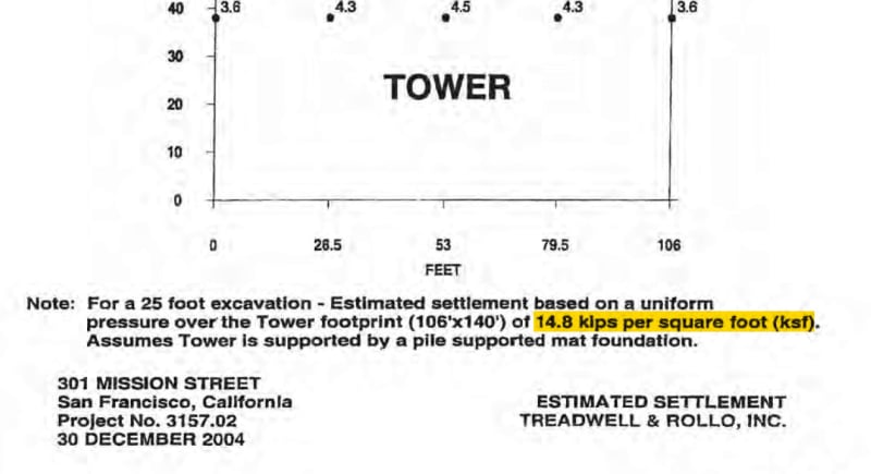
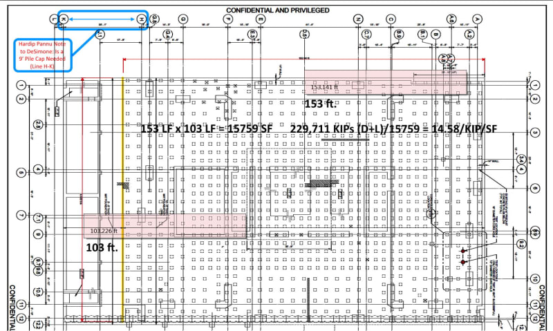
DeSimone's project foundation calculations submittal gives a load of 14.8 ksf for a 106' x 140' piled foundation. The plan view submitted by Lera/ENGEO for the previous solution, the symmetrical piling upgrade, was for the as-built, 103' x 153' piled foundation for 14.58 ksf.
Here is a comment from the 'expert' panel that reviewed the current Perimeter Pile Upgrade for SFDBI. Part of the commentary is in regards to work done by Lera/ENGEO.
Here are a couple of links to articles in Structure Magazine. One by Ron Hamburger of
SG&H and another by the
Slate geotech people.
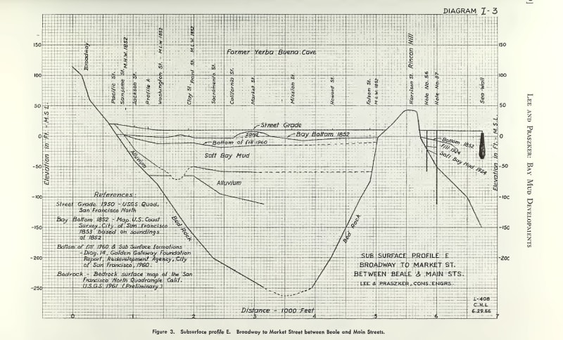
I thought the
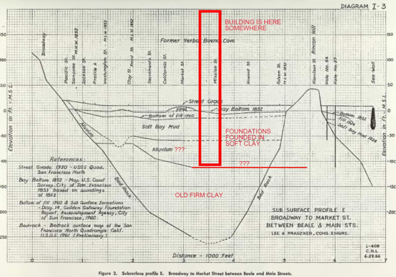
ground profile the perimeter piles will pass through was interesting.
This paper on the
Geology of San Francisco gives some interesting characterization to Old Bay Clay and Cloma Sand Hydraulic Coefficient.
...Hydraulic Conductivity:
The hydraulic conductivity of the Colma Formation is generally lower than would be expected based on the
typically fine to medium grain size of the strata. This probably results from the material in the interstitial
space between the sand grains that can contain silt or clay particles, in addition to calcium carbonate
cementation and iron oxide precipitation. Hydraulic conductivity values for the Colma Formation typically
range between 1x10⁻⁵ and 1x10⁻³ cm/s (Johnson, personal communication). While sandy zones at the higher
end of the hydraulic conductivity range are common, the overall character of the Colma Formation is that
it more often exhibits conductivity values toward the lower end of this range.
The hydraulic conductivity of Yerba Buena Mud/Old Bay Deposits strata will depend on the textural variations in the strata (i.e., sand or clay). While the overall depositional setting for the Yerba Buena Mud/Old Bay Deposits was a marine environment resulting in predominantly fine-grained deposits, significant yet discontinuous lenses of sandy material are quite common. As such, the sandy horizons generally exhibit hydraulic conductivity values between 6 x 10⁻⁴ and 2 x 10⁻³ cm/s (Johnson, personal communication). These values are relatively large; however the limited extent of these lenses cause the overall hydraulic conductivity of the deposit to be dominated mostly by the clayey strata where the hydraulic conductivity is typically lower, with values ranging between of 10-7 and 10-5 cm/s (Johnson, personal communication). END
The ground between the Out-rigger Super-Cloumns on Fremont St. seems to be quite complicated. Maybe they should of hired Michael D. Holloway from Insit-u-tech, the Geotech who performed PDA & CapWap on the tower Indicator piles to the 'Expert's' review of the Perimeter Pile Upgrade; since he's the only person who was involved in the 301 Mission Street project that thought the PDA & CapWap showed more ground investigation was warranted.
As for the replenishment of ground water to the general vicinity of Fremont & Mission streets, shoring walls for the Transit Center & Salesforce Tower block Rincon Hill from draining to north toward Mission St., and Mission St. from which is the bottom of an ancient ravine. The Transit Center & Salesforce Tower shoring/cut-off walls, two in each direction, penetrate 5 to 15 feet into the Old Bay Clay. Then, there is the -90' tower/podium shoring wall, without a vertical gradient above -25. The Transit Center & Salesforce tower are underground levies, blocking groundwater recharge.
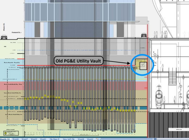
A proper representation of the piles in profile along Fremont St. shows the shortest spec'd piles, don't reach a sand layer, based on Treadwell & Rollo's original bore logs.
The yellow points represent 2/3rds the pile length, exclusive of the mat.
![[lol]](/data/assets/smilies/lol.gif "[lol] [lol]")