Continue to Site

Eng-Tips is the largest engineering community on the Internet

Intelligent Work Forums for Engineering Professionals

  • Congratulations KootK on being selected by the Eng-Tips community for having the most helpful posts in the forums last week. Way to Go!

FEMA's Outdated Flood Zone Maps 21

Oops409

Mechanical
Apr 25, 2024
193
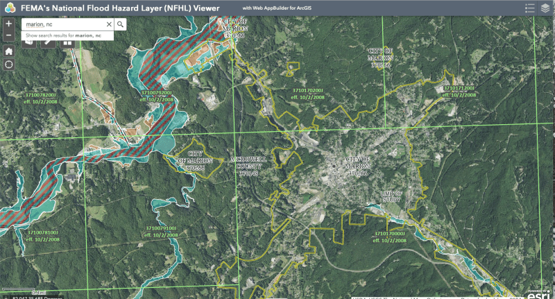
Only 3% of residents in Asheville, NC, for example, had flood insurance, according to an article I read. Looking at FEMA's Flood Maps, it is understandable why residents would not have flood insurance.

FEMA flood maps will need to be updated to reflect modern risks, and risks due to more and more urbanization and growth since maps were developed, along with whatever weather cycles we are now experiencing.
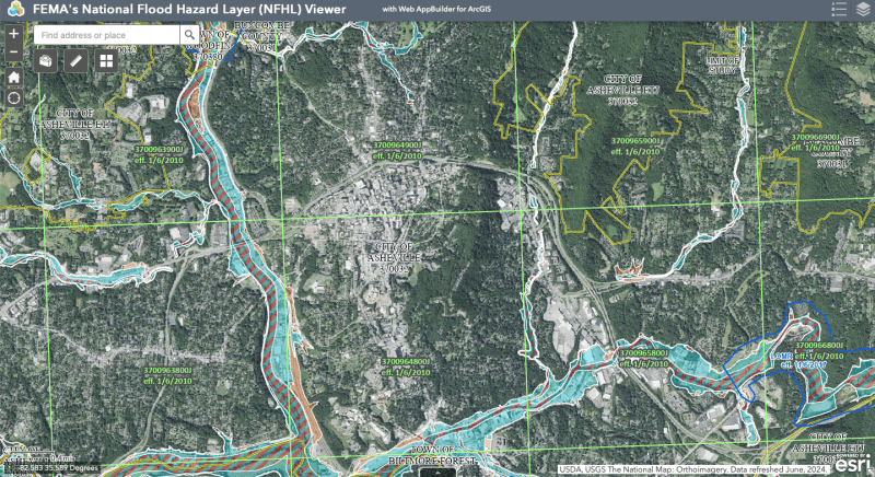
Screen_Shot_2024-10-04_at_2.44.28_PM_ufmkwl.png


Marion, NC below

Screen_Shot_2024-10-04_at_3.06.57_PM_mxaqdk.png


Replies continue below

Recommended for you

We were not responsible for the movement of the tectonic plates, except for fracking.

-----*****-----
So strange to see the singularity approaching while the entire planet is rapidly turning into a hellscape. -John Coates

-Dik
 
We try to slow the motion of the structures.

As new records are set, the probability frequency is updated, or rather the amplitudes of the existing frequencies are revised. The net result is similar. What is a 1000 Yr event now may become the 500 yr, or 100 yr event of next year.

My guess is they'll keep building until 100yr storm criteria gets too expensive to construct the defenses.

--Einstein gave the same test to students every year. When asked why he would do something like that, "Because the answers had changed."
 
Certainly one can increase the rate of earthquakes as Oklahoma has shown by simply allowing deep injection of high pressure lubricants to fracture otherwise solid rock.
 
Thanks... comment corrected.

-----*****-----
So strange to see the singularity approaching while the entire planet is rapidly turning into a hellscape. -John Coates

-Dik
 
I'm going to double down on this thread is not an engineering failure or disaster. The storm and flooding are natural occurrences, and human disasters. Storms have been scouring those canyons for millenia. There was no failure of human-engineered structures that caused the flooding - the Nolichucky Dam (built in 1913) was on the verge of failure but held, while sustaining record flow rates. As has been stated, FEMA flood maps are a human/societal creation for assigning risk and are manipulated to balance projected loss of life and land, preservation of land values, and economic impact. None of these can all be optimized without impacting another. As the last posts have pointed out, the real engineering challenges start now with the rebuilding and mitigation.
 
So are you saying weather related failures have nothing to do with engineering, or cannot cause engineering failures? Are you saying we can't dicuss a roof colapse due to ponding rainwater, or downbursts, hurricane winds, Santa Ana winds, tornados, meteor impact? Nothing related to weather or natural occurrences, right?

If you remove indirect engineering related failures, it seems like that reasoning would also apply to any failure caused by natural causes; earthquakes, tsunamis, landslides, (not caused by weather), volcanos, fire? If a building falls over because someone excavated the adjacent lot, or was building a tunnel below, can we talk about that, or does some engineer have to bungle his calculations to make something a literal engineering failure? So we shouldn't talk about pipeline failures due to sabotage, or cargo ships blocking Suez, or Beruit damage from the harbor explosion, flooding in Algeria, or... you know, those things you might not have objected to.

What qualifies for discussion here Brian?
Why are you even worried about it? Are we using too much Paper? Is it an Internet energy use thing?


--Einstein gave the same test to students every year. When asked why he would do something like that, "Because the answers had changed."
 
If an item is engineered to meet a requirement of withstanding a storm event and it fails that is an obvious discussion point. If an engineer bungles a calculation, certainly. Waxing about FEMA flood maps as an engineering failure is a stretch because flood maps are manipulated to achieve goals different than pure public safety. Additional, they are not updated at a frequency appropriate to the change of the environments they are purported to protected - that is a political/administrative issue and not engineering. I think there have been some interesting observations made in this thread but I am missing the engineering failures.
 
"FEMA flood maps are a human/societal creation for assigning risk and are manipulated to balance projected loss of life and land, preservation of land values, and economic impact."

Are you saying that FEMA flood maps are based on things other than rainfall, topography, soil and and surface use classifications, being corrupted by local real estate developers and land owners? Are you just throwing that out to see if it sticks, or do you have evidence. Their policy seems to only allow changes based on appeal supported by scientific evidence.

FEMA Policy

"Members of the community have opportunities to submit evidence on why they believe their property has been improperly mapped. However, the evidence must be scientifically or technically based. Even if “it hasn’t flooded in a while (or ever),” technical analysis can show that the risk exists.

During the 90-day appeal and comment period, you can submit:

An appeal, which is a formal written objection to a new or modified BFE, Special Flood Hazard Area (SFHA), floodway, or flood zone This must be supported by an analysis or scientific evidence showing that the information on the preliminary map is scientifically or technically incorrect.

A comment, which points out changes needed for any other information related to the updated map (such as a street name or jurisdictional boundary).

After the appeal period, FEMA will evaluate the data in the appeals and comments and request additional data, as necessary. Once all appeals are resolved, FEMA will send an appeal resolution letter to the community and all appellants and revise the preliminary flood map as appropriate. After that, FEMA will finalize the flood map and send a Letter of Final Determination to each community, stating that the map will become effective in six months."

That doesn't appear to leave a lot of room for manipulation. Changing data of the National Weather Service and USGS topo maps could easily be detected.

Is not the engineering failure here the fact that engineers are using outdated flood maps, rather than recognising that problem and having their own waterway analysis produced before doing their project design work in a risk prone area.


--Einstein gave the same test to students every year. When asked why he would do something like that, "Because the answers had changed."
 
1503-44 I have not said FEMA maps are not based on science, measurements, and data. They certainly are. But they are also manipulated based on governmental and economic influences. I am not saying necessarily corrupt, but city development, farming operations, land development and insurance entities influence how the maps are structured. Manipulations occur with some runoff calcs if a municipalipality treats 'street-side' storage the same as retention basin storage, etc. How a subdivision can be built within a given risk zone influences decisions. The changes of local/regional runoff capture do not immediately change FEMA maps.
 
Influence could mean corruption, if such influence is not based on technical evidence. If it is based on evidence, it c/should be considered. If side Street storage hydraulics is considered by the engineer of record to be part of a proper analysis, its hard to call it corruption. Its his professional opinion. If you think it's in error, appeal. Where is the undue influence you allude to?

Flood maps are not a prohibition to build. They are to inform the public, lenders and insurance companies of the risk in doing so. I think you will find that most developments that are located in flood zones today were not built in flood zones at the time of construction.


--Einstein gave the same test to students every year. When asked why he would do something like that, "Because the answers had changed."
 
As far as I can tell the only things that FEMA flood maps deal with are catch basin, local topology, and likelihood of a large storm with a 1 in 100 chance (for 100 year floods) of happening.

Their use, however, is "for assigning risk and are manipulated to balance projected loss of life and land, preservation of land values, and economic impact."

That is the reason they are made. For political and economic judgments, which is what makes this thread not about engineering when it remarks on the FEMA maps.

I don't see a cost-effective adaptation to conditions where dirt up to 30-100 feet deep over thousands of acres will suddenly depart the area of a structure, taking all the roads and other infrastructure with it.

Those who suffered from landslides? I doubt they had an engineer reassure them they were in a completely safe location.
 
Remember as well alot of the maps are now null and void. Due to the statistical data they are based on is now null and void due climate change.

The codes need revamped never mind the maps.
 
The offshore platform structural design codes were revised after Katrina in 2006. They probably could use a revisit now that this storm was said by some to have reached a yet nonexistent CAT6. 200 MPH wind.

Dave, I may be wrong but I think the work behind them is far more comprehensive than you realize.


Colorado program

Harris County (Houston) program story

--Einstein gave the same test to students every year. When asked why he would do something like that, "Because the answers had changed."
 
1503-44 I am not inventing any about FEMA maps manipulation. It happens for various reasons. One example is stated in this Washington Post article.

FEMA says it wants to move beyond the “binary” model of flood risk, and last year it introduced a more sophisticated method of pricing flood insurance. But its maps still guide regulations and planning.

FEMA is required to reassess flood maps every five years, but new ones take an average of seven years to finish, officials have told Congress. The agency works with local and state officials during the revision process, and communities may resist expanding designated flood zones because it adds costs and can hamper development.

“You would think, well, FEMA could just update the maps in issue,” Fugate said. “That’s not true. … Local governments have been opposed to any maps that show an increasing risk.”

In addition to the maps being out of date, some decades-old in a changing climate, another problem is how the maps are built in the first place. They capture river and coastal flooding, not inundation caused by intense bursts of rainfall, known as pluvial flooding — a particularly dangerous problem in cities, where many porous surfaces have been paved over.

I am certainly not "just throwing that out to to see if it sticks"

Obviously everyone has an opinion, I have mine and I have put it out there but I am not going to invest too much effort in arguing - that is not my intention.
 
Nothing there is evidence of undue influence.
Communities resist. Any public or private entity may appeal with technical evidence. and it will be resolved based on the technical evidence.

If there was better funding, the maps could be produced within the alloted time. A map does not take 7 years to produce. It takes 7 years to complete the cycle of updating all of them.

FUNDING is the only problem, but then it's difficult to even keep the lights on in Congress these days. Flood maps are only a problem when it floods. The solution to that, based on the latest and loudest amongst the party controlling the House, is simply to stop funding the gov controlling the weather. Win/win. No money spent and climate change vanishes.

--Einstein gave the same test to students every year. When asked why he would do something like that, "Because the answers had changed."
 
From aviation in Florida they are saying it's different to the previous hurricanes.

The tornadoes are also different in the way they behave.

Some have also been saying the sea is reacting differently than previously.

Most of the links are blocked to me as I am in the EU. The reported in changed hurricane behaviour is interesting.

 
Geoengineering: Can we control the weather?

In 1974, during the Vietnam War, the U.S. army used cloud seeding to alter the weather. The aim was to prolong the monsoon season in Vietnam, making fighting more difficult for the enemy. The plan was named Operation Popeye and meant that the U.S. troops were more prepared for the extensive rainy season, according to documents posted online at the Office of the Historian. Operation Popeye used the rain as a weapon to destroy roads and flood rivers.

Seems there is lots of science and engineering going on to manipulate the weather? Source links contained in article. Perhsps flood maps are just lagging the consequences?

 
No doubt that a microclimate might be temporarily affected by cloud seeding, but I have extreme doubts that it would last for more than a few hours. Cities are thought to increase local temperatures, which may also affect cumulus cloud formation and rainfall in an area with generally favorable conditions already, but Lacking specific proof, at least there is a microdot of scientific logic behind that reasoning. As for the global context and creating a CAT6 hurricane, or multiple and frequent massive storms the comments were framed against, that shall I say defies all logic in my book, except for branch titled hopeless nut jobs.

--Einstein gave the same test to students every year. When asked why he would do something like that, "Because the answers had changed."
 
I would expect a larger heat island to evaporate more water vapor into the air, to create a higher local humidity.
Thus more local rain. But I would think some of that would dissipate with higher winds.

Maybe start a conspiracy theory that China has been cloud seeding with hot air balloons.
 
There's enough of both being floated around at the moment.

--Einstein gave the same test to students every year. When asked why he would do something like that, "Because the answers had changed."
 

Part and Inventory Search

Sponsor