Eng-Tips is the largest engineering community on the Internet

Intelligent Work Forums for Engineering Professionals

FEMA's Outdated Flood Zone Maps 21

Oops409

Mechanical
Apr 25, 2024
187
0
16
US
Only 3% of residents in Asheville, NC, for example, had flood insurance, according to an article I read. Looking at FEMA's Flood Maps, it is understandable why residents would not have flood insurance.

FEMA flood maps will need to be updated to reflect modern risks, and risks due to more and more urbanization and growth since maps were developed, along with whatever weather cycles we are now experiencing.

Screen_Shot_2024-10-04_at_2.44.28_PM_ufmkwl.png


Marion, NC below

Screen_Shot_2024-10-04_at_3.06.57_PM_mxaqdk.png


Replies continue below

Recommended for you

"could disrupt the housing market and directly impact homeowners"

Floods have the same consequence, except that it's not just value that is destroyed.
People die, damages are suffered, local economies are whiped out.

The important point to note here is that the true values of the properties have already decreased with the increased risk of flood. Maps had nothing to do with that. True property market values may not be reflected in current market price only because the flood maps are not yet consecrated by the powers that be and their information has not been placed in the public domain. "Its still secret information", any info not freely available to the general market, If we were talking about trading Wall Street stock, trading on insider informationi is very much illegal. Information affects market prices.

Apparently, or at least the consequences of the Professional Association of Real Estate Brokers warning, which seems to be to not release new flood maps, or otherwise upset the market with a release of the latest flood information. That allows real estate prices to continue to be set based on the false market perceptions that result. This is illegal trading, or at the very least, highly UNPROFESSIONAL advice on the part of the real estate brokers association.

(I sent the reporter this comment.)

--Einstein gave the same test to students every year. When asked why he would do something like that, "Because the answers had changed."
 
Never, but here they are a little blatant about it.

--Einstein gave the same test to students every year. When asked why he would do something like that, "Because the answers had changed."
 
...thanks to the ongoing climate crisis, the weather has been and continues to be quite unpredictable. Climate change has caused inaccurate reporting of areas that are prone to widespread flooding.

However, FEMA’s website does offer property owners who have been affected by floods from natural disasters, that are not currently mapped out as being in a flood zone area on FIRM correctly, the ability to correct that discrepancy by submitting the required documentation and information for FEMA to investigate the error, and make the necessary corrections through their “Change Your Flood Zone Designation” page.

So they can ask FEMA to fix it and it is due to climate change.
 
Appears to be opinion piece, with some factual information included. Only reference I saw was link to FEMA.

It is not clear whether public individuals can appeal and affect flood map changes for just their property, without affecting surrounding properties, thus bringing in the Local Government Officals and Real Estate Brokers to argue against it? Doubtful one property owner can affect change along a creek/river in a mountain valley, if politicians/powers that be don't agree.

The real question is, does the secretive FEMA flood risk information include Appalachia mountain valleys, but that information is just hidden from public view?

Margherita_Marullo_TheTravel_iixfqm.jpg
 
They can ask FEMA to fix it. No. Or yes, in a way. According to FEMA stated policy a flood map delineation can be appealed with proper technical support data. A decision will be taken based on technical evidence.

--Einstein gave the same test to students every year. When asked why he would do something like that, "Because the answers had changed."
 
FEMA said:
Paper Application Forms for Letter of Map Changes

Looking at FEMA's Change your flood zone designation process, it requires fees from requestor be paid to FEMA, and link makes it clear what 1503-44 says about FEMA has to determine a technical reason for change. Process also requires lots of Technical Engineering Documentation and Analysis to support application for change to FEMA.

I think the opinion piece is very misleading. Yes individuals can spend money and submit requests for change, but odds of that having any effect is slim.

The main benefit I can see individual property owners might have, is that if they build up a lot in the flood plain, such that it is now above the flood plain, they can request that lot be removed from flood zone and not have to buy flood insurance. In a lot of cities, it is common practice to force developers to raise ground level in flood designated areas, if they want to build on land contained in flood zone.

 
"According to FEMA stated policy a flood map delineation can be appealed with proper technical support data. A decision will be taken based on technical evidence."
or
the local real estate "professionals" appeal to their local congresscritter (whom they generously "donate" to) to be sure FEMA doesn't mess up "local real estate values".
 
In this case there are areas with thousands of property owners who would all use the same estimation methods to provide a report to FEMA - exactly the function that local and state government is supposed to perform to support their side of interacting with FEMA. Placing this on individuals is something of a scare tactic.
 
I doubt the FEMA appeal process is useful for identifying the possible extent of Riverine Flooding similar to what occurred in Haleen.
See attached, the standard mapping line for the extent of Riverine Flooding still uses a base flood line of 1-percent-annual-chance flood elevation (100 year flood).

The mapping standards do not have a provision for placing a line on the map for less frequent events.
 
 https://files.engineering.com/getfile.aspx?folder=654d704d-eee7-44be-9ca5-03d44800ee8c&file=fema_riverine-mapping-and-floodplain-guidance.pdf
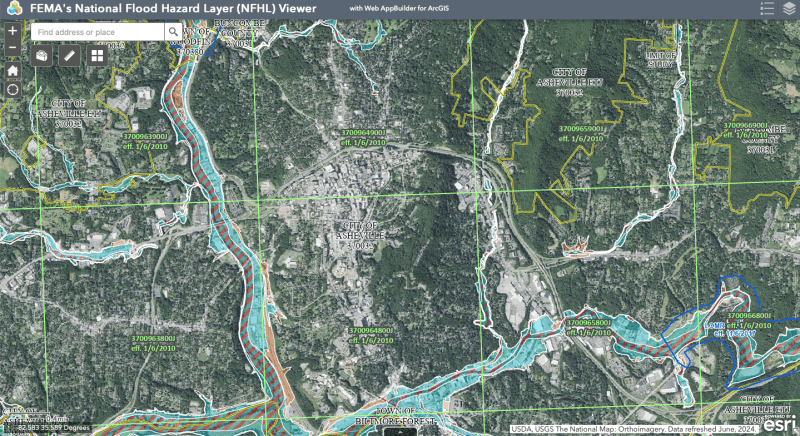
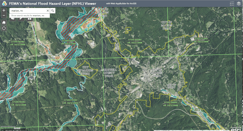
Why the doubt? The 100yr design condition changes with updated rainfall and all relevant hydrologic, topographic, land use and surface coverage data. The new 100yr event will theoretically produce a design flood of correspondingly greater proportion and magnitude, if any information has significantly changed since the last map was issued. This is exactly the reason that updates are needed. The design storm event and the many other associated factors are not static. They are very much dynamic, increasingly so with the climatic changes we are witnessing today.

The appeal process would apparently allow an appeal, if it can be technically proven to have errors in the delineation of the design flood (the 100yr event). The key to that is to check that the latest WNS 100yr storm frequency data was used to develop the map and all the associated hydrologic and topographic information is current. If any of that data has subsequently changed, then the new map is potentially inaccurate and the appeal is most likely accepted. If Helene data is not yet in the NWS database, ask in the appeal ask to revise the NWS database as well.

The only danger I see is if new data shows that changes to the map are necessary, but an appeal is deliberately quashed, unknown to FEMA, in favor of not wanting the correct information to "affect the market". In fact, remembering that Ashville has experienced a greater flood in the past, that would be my greatest concern, as it would potentially cause exactly the same situation and type of damages we see before us today. If I was looking for a smoking gun, that's where I would begin my search.


SWcomposites said:
or
the local real estate "professionals" appeal to their local congresscritter (whom they generously "donate" to) to be sure FEMA doesn't mess up "local real estate values".

Or even more likely, the real estate guys call their Congressman and say "Do not make funds available for this flood map update program. It smells of that woke fake climate change thingy. Better to keep the House's lights off."

--Einstein gave the same test to students every year. When asked why he would do something like that, "Because the answers had changed."
 
NOAA Atlas 14 Precipitation-Frequency Atlas is one input to the FEMA flood maps. If you delve into the technical underpinnings of the Precipitation Frequency Atlas you will find that an attempt to include the impact of orographic lifting was made, and recognized as imperfect.

Screenshot_from_2024-10-22_05-15-46_fdb4bb.png


Precipitation-Frequency Atlas of the United States Volume 2 Version 3.0: Delaware, District of Columbia, Illinois, Indiana, Kentucky, Maryland, New Jersey, North Carolina, Ohio, Pennsylvania, South Carolina, Tennessee, Virginia, West Virginia

This page on NOAA's website Modernizing Probable Maximum Precipitation Estimation indicates for lack of funding there was a gap in NOAA's efforts.

[URL unfurl="true" said:
https://www.weather.gov/owp/hdsc_pmp[/URL]]Since the late 1940s, the NOAA’s National Weather Service has provided PMP guidance and at the request of various federal agencies and with funding provided by those agencies. This funding has diminished and gradually ceased, and as a result the NWS could not continue the PMP activities.

With the 2022 Bipartisan Infrastructure Law (BIL), NOAA received the first-ever direct Federal funding to update PMP estimates for the entirety of the United States. To assure that the best science is applied to this important task, NOAA is first sponsoring a study by the National Academies of Science, Engineering, and Medicine called “Modernizing Probable Maximum Precipitation Estimation.” Please see the project website for more information and a way to sign up for project updates.

One of the referenced documents, likely an input to the current atlas 14 is Probable Maximum and TVA Precipitation over the Tennessee River Basin above Chattanooga June 1965

This whole process is technically challenging, and requires data which requires the passage of time (unless you want to create the data from weather models, which would increase the uncertainty of the result).
 
Some interesting reports there.

Weather models would not necessarily increase the uncertainties if your actual data is lagging the dynamics of climate change.

According to
(Dated 18 July 2024)
K​entucky is the most recent state to set a new 24h rainfall record – 11.28 inches on July 18-19, 2023.

That was a year ago and may be outdated already, given its not so far away from Helene's track. A weather model considering possible variations in Helene's track might indicate if KY 11.3" still looks adequate, or if it needs to look more like TN 20.7". I have not seen Helene's 24h rainfall data yet. Could make for a very interesting comparison.

v250-states-24-hour-rain-records_fbeszb.jpg


(I did not know that TX had 42". And I'm wondering how ITH LA escaped a similar fate.)

--Einstein gave the same test to students every year. When asked why he would do something like that, "Because the answers had changed."
 
Texas got 42 inches due to a NOAA reporting station ( being at the location of the record rainfall so it could become part of the official record.

42 inches, set in Alvin, Texas, on July 25-26, 1979, when Tropical Storm Claudette soaked the state.

Except for no official reporting station being present at the location of heaviest rail, virginia would have a record rainfall close to 40 inches.
([URL unfurl="true" said:
https://en.wikipedia.org/wiki/Hurricane_Camille)[/URL]]Though the official rainfall was recorded as 27 inches (69 cm), unofficial estimates are much greater. Some estimate that more than 40 inches (100 cm) of rain fell at Davis Creek. Most gauges were washed away; however, it was reported that an empty 55 US gallons (210 L) drum that was not even in the center of the heaviest rainfall had 31 inches (79 cm) of water in it after Camille passed.
Accounting for this effect in the dataset required some creativity.
 
Claudette

I was in Houston in 79 and 83 (Camile). Both were very wet storms. Alicia (also 83) washed out a number of my Galveston to Port Lavaca fishing spots. I was living behind Barker Flood Control Dam then wondering how high the water would get. Alicia knocked power out for an entire week and the humidity was the worst I ever experienced ... until I got to Dubai.

Creative Datasets
Oddly enough Claudette came ashore close to NOrleans, but Tx got the rainfall record. That seems very problematic, as I can't see any reason that Lousiana could not experience a similar 42" rainfall in 24 hours, yet their 22" in the map above is nowhere close to 42. It would seem that the potential for 42"/24h also exists in LA and MS, GA, FL, AL. SC, NC and VA. I believe that illustrates exactly why we cannot entirely depend on actual records to predict future events. Noting that these storms were not recent events, possibly entirely free of climate change effects, there may be some potential for even greater magnitude events waiting around the corner. Modeling max possible storm intensities might fill that gap. In fact without it, we may be sitting ducks.

Note that the record historic 24h rainfall is probably not used in delineating flood maps, since an all-historic record may translate into a return frequency of 1000yrs. We need to have a look at current maximum potential rain frequency records and see if they may be underestimated because of being based (supposedly) on actual data alone. I had a look at the Max Precipitation calculations of California, since that was the latest study of 1998. They attempt to model the individual basins. Since that one is now 25yrs old, all of these reports are surely based on more rudimentary forms of analysis and may benefit from more modern techniques that have certainly become available since then.

1280px-Continental_United_States_Hurricane_Strikes_1950_E2_80_932021_n9e3ei.png


--Einstein gave the same test to students every year. When asked why he would do something like that, "Because the answers had changed."
 
When the rotation period gets to 1 year... were doomed.

--Einstein gave the same test to students every year. When asked why he would do something like that, "Because the answers had changed."
 
Back
Top