Continue to Site

Eng-Tips is the largest engineering community on the Internet

Intelligent Work Forums for Engineering Professionals

  • Congratulations waross on being selected by the Eng-Tips community for having the most helpful posts in the forums last week. Way to Go!

Miami Beach, Champlain Towers South apartment building collapse, Part 16 24

Status
Not open for further replies.

dik

Structural
Apr 13, 2001
25,681
thread815-484587
thread815-484717
thread815-484915
thread815-485059
thread815-485171
thread815-485223
thread815-485379
thread815-485535
thread815-485637
thread815-485844
thread815-486084
thread815-486593
thread815-487022
thread815-488247
thread815-489644

Rather than think climate change and the corona virus as science, think of it as the wrath of God. Feel any better?

-Dik
 
Replies continue below

Recommended for you

IanCA said:
Is it possible that the removal of 87 Terrace also had some impact on the lateral stability of the CTS property line wall? With respect to thermal expansion of the parking deck & pool deck?

Interesting thought, as the concrete walk was poured up against wall. Not sure whether poured against concrete wall though. But definitely had a water change due to removal, and yes I guess road way and concrete curb and walk did provide lateral bracing to concrete wall, at least due to compaction of ground under street and walk.
 
thermopyle2.1 (Military) said:
Again, building to line invites problems

I concur. I was thinking "terrace" was the old Hotel that was torn down. So the removal.... well that's where I missed that it was the road you were talking about. So not just was the road removed as such but the land was repurposed with no apparent interest in what function it was providing to CTS before or whether it was access or whatever. It just had no priority.

You can not even paint your retaining wall without getting permission to be on the other person's property.

That is a very interesting point. Does this explain why they did not even attempt to fix the water coming it, assuming they knew about it. If this was all understood as a fact before the collapse, why didn't they use the law to address it? This kind of crap is Judge Judy territory. Damage caused by action of neighbor? But because of politics maybe they couldn't? This part really seems to stink and suggest there is more going on that has been told. These are the questions that beggar the imagination. And I believe they are claiming this now as if it was a known fact then.

Edit I now see Morobito attributed about $80K in damage to the privacy wall to 87 Park construction. I don't know is this is just where they scraped it with an excavator or more than that. And he noted the drainage being funneled towards CTS - which is denied by the developers. So there is the pissing match.
 
I don't know anything about the property laws in Florida but my property line is actually the center of the street and the city has an easement for the street and all the utilities that pass my house. I can landscape right up to the edge of the street as long as it doesn't create a safety hazard for motorists but they won't replace my daisies if they need to dig up the water line.

If CTS's real property line was the center of the street it may explain why 87 Park wasn't able to build right up against CTS's sheet piles and why they were required to rebuild a public sidewalk access to the beach on the old easement.
So did only one city own and maintain this street or did they share that? Were both cities required to sign off on the sale of the street? Is the city responsible for the water problems caused by it's sidewalk? Seems like some real murky legal issues need to be resolved before the other blame games can continue.

[sub]I fought the law and the law won.[/sub]​
 
I know CTS had THEIR city building inspector come around, who essentially said "It's not my jurisdiction." He MAY have been otherwise unhelpful. Or he may have suggested other routes to ease their concern.

Did anyone at CTS think it appropriate to get an engineer's opinion on problems they could encounter with the neighboring construction?

If so, what did that engineer say?

If not, why not? Was it considered not important enough?


spsalso
 
Nukeman948 said:
If CTS's real property line was the center of the street
Understood. I just checked it is at the CTS southern wall.

Suggestions welcome.​
 
IanCA said:
I just checked it is at the CTS southern wall.

Is there any chance you could check to see who owns that public sidewalk?

[sub]Just asking questions.[/sub]​
 
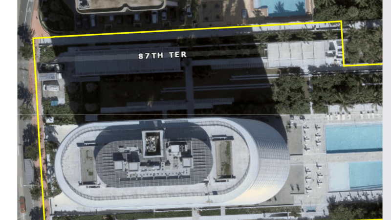
B268FC5A-84F2-4706-AC57-3D99DAE4B969_jwluww.png


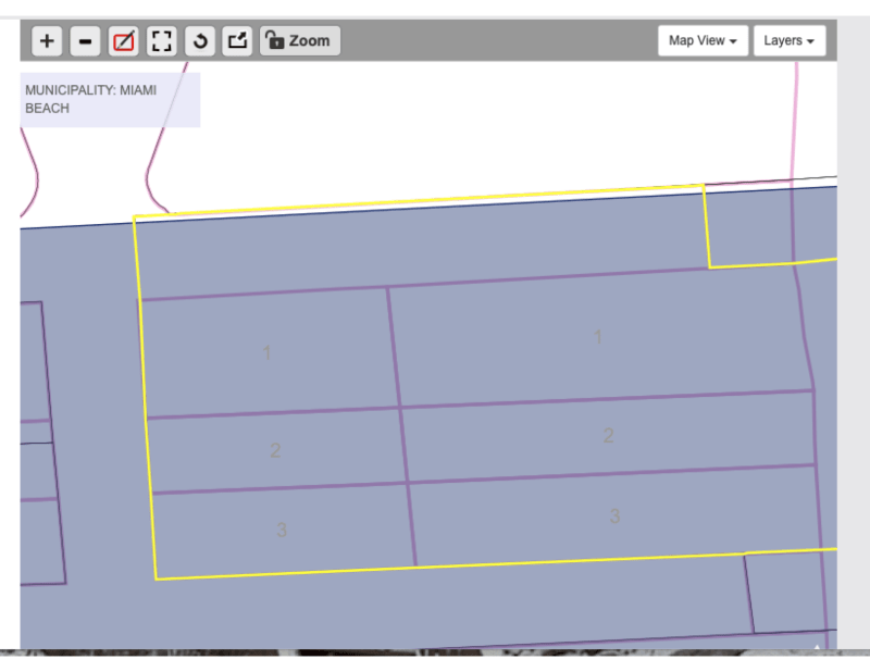
lots_xbxgdg.png
 
8701 Collins

From Miami Dade GIS Maps


Here is legal description on 8701 COLLINS AVE CONDO. Looks like 6 lots, part of erosion way and adjustments to Blocks 1 and 10, plus 50 ft road closed. Would need to look at plat books, and deeds cited below to see full details. But it appears City Sold Right of Way of Road from this. Perhaps public access is an easement on property?

ALTOS DEL MAR NO 2 PB 4-162
LOTS 1 THRU 3 INC BLK 1 & LOTS 1
THRU 3 BLK INC BLK 10 & PORT OF
EROSION WAY LYG BETW & ADJ TO
BLKS 1 & 10 PER PB 105-62
& 50FT RD LYG N & ADJ CLOSED
PER RES #2014-28608 & 2014-28839
AS DESC IN DECL 31691-1664
LOT SIZE 101179 SQ FT
 
Is the West edge of that property shown in the aerial photo actually running down the center of the sidewalk? So does that mean it has been confirmed that the property line is not the center of the street?
Is that considered good enough for legal work in Florida?
Were all the laws adhered to in the sale of a city street to a private entity?
I seem to remember some of those issues haven't been fully explored in court yet.


[sub]Call me skeptical.[/sub]​
 
Skeptical, The aerial photo looks like property line is running along North edge of sidewalk to me. If you click link and go to their GIS map site, you get a lot better image than that to look at.

In my state, property lines are typically not the center of streets. In plat mapped residential sub-divisions the street Right of Way is say 50 feet wide, but road is only perhaps 30-35 feet curb to curb. The other 15-20 feet are divided evenly on each side of road and are basically used for utilities. So property lines for lots are typically not at curb of street but 7-10 feet past curbs. So you end up maintaining part of the right of way for the city.

Definitely some shady dealings went down, and I expect it to be interesting legal battle.
 
thermopyle2.1 said:
The aerial photo looks like property line is running along North edge of sidewalk to me.

No. I was talking about the WEST edge that runs along Collins Ave. But then your other image shows the property crossing the city limits into Surfside on the North. Not sure how that works. Really doesn't matter, it's not going to get resolved here.

I know if I don't mow that 15-20 feet of lawn along the street, the city will come do it for me and send me a bill.


[sub]Call me Skeptic Al.[/sub]​
 
Skeptic Al. said:
I know if I don't mow that 15-20 feet of lawn along the street, the city will come do it for me and send me a bill.

I assume the city just has easement on your property, thus you are still the owner and have to cut the grass? I know here, if the lot is vacant, and a complaint is filed the City will cut the right of way grass in front of vacant lot and not charge the land owner, since the land belongs to City. But I do not know what would happen if I quit maintaining the ROW in front of my house for the City. Perhaps they would come cut it too as it is their land, but I am not aware of anyone who has tried not cutting the ROW on a developed lot.

My guess is City would cut it on developed lots too, but it would NOT endear the land owner with the Power Brokers at City Hall?

 
@Thermopyle2.1, thanks for finding and sharing that information. I like it.

I started from here: Link, zoomed-in and clicked on the location. But it's not as user-friendly.

The GIS version you shared has more features and information, but the land use data is different. It still shows 87 Terrace as a road.

Thermopyle2.1 said:
But it appears City Sold Right of Way of Road from this.
The story I heard was that sale of public roads was not permitted so it was given in exchange for a cash donation.

Nukeman948 said:
Is the West edge of that property shown in the aerial photo actually running down the center of the sidewalk?

Looking at Google street view. The width of the sidewalk was approximately doubled when 87 Park was built. The property line aligns closely with the original sidewalk.

Suggestions welcome.​
 
Nukeman948 said:
So does that mean it has been confirmed that the property line is not the center of the street?
Is that considered good enough for legal work in Florida?

As an engineer. Did you know it was engineers week? I would say that the data available in the public copy of the official record indicates that the beach access path entirely crosses the property referenced by Folio: 02-3202-165-0001, which is abutted immediately to the north by the property previously occupied by CTS and referenced by Folio: 14-2235-025-0001. As such, as far as public records show, there is currently no publicly held land located between Folio: 02-3202-165-0001 and Folio: 14-2235-025-0001.

Nukeman948 said:
Were all the laws adhered to in the sale of a city street to a private entity?
I seem to remember some of those issues haven't been fully explored in court yet.

Good question. I completely agree.

Nukeman948 said:
If CTS's real property line was the center of the street it may explain why 87 Park wasn't able to build right up against CTS's sheet piles and why they were required to rebuild a public sidewalk access to the beach on the old easement.

I suspect the Miami Beach council was simply under pressure to maintain public beach access, but from what I can see, they still transferred the entire piece of land previously occupied by 87 Terrace to the owners/developers of 87 Park.

Suggestions welcome.​
 
IanCA said:
As an engineer. Did you know it was engineers week?

Yes, it seems everyone has a manufactured holiday based on their job title to make them feel good about themselves and forget they are nothing more than a cog in someone else's money machine. When the cogs are worn and out of spec they get tossed in the scrap bin with all the rest of the used up dregs of the world.

There is no children's day because every day is a holiday for children. There is no holiday for retiree's for the same reason. Cogs that are not yet useful and cogs that are no longer useful. And the useful cogs and the machine owners have no use for either one.

If you build your own money machine you will find an ample supply of cogs looking for a place to fit in. If you work the machine too hard, some cogs will break from the stress and some will be ground to a fine powder. But churning out money is the only freedom that they know. Slaves to someone else's empire of greed.

And yet we keep building larger and larger machines. Soon we find Cogswell Cogs and Spacely Sprockets are competing with each other to have the largest money machine ever imagined. Rakes and shovels and implements of destruction to scoop all that money into the largest pile of money that man has ever known.

I have no idea where I was going with this and no idea why you thought a made up holiday was relevant.

Welcome my son. Welcome to the machine.

Is this question rhetorical too?


[sub]For longer life, keep your backlash within spec.[/sub]​
 
Nukeman948 said:
For longer life, keep your backlash within spec.

Is this creative writing or has a Sparky set up ring and pinion gears in a differential?

What I would like to see if the complete deeds and plat maps posted on line from before current 8701 Collins owner purchased property and tore down existing building, coupled with before and after ROW transfer from City to current 8701 Collins owner, and today's plat maps and deeds.

In my County and City all this information has been digitized and these public records can be accessed on line, rather than the old method of going to county record room to manually research deeds, mortgages, plat map, etc. records. At least ours are digitized back to around 1990 time frame. Beyond that manual look up still required.

I could not find access to actual deeds and plat maps for Miami-Dade on line, where we could see complete legal descriptions of parcel's of land and how title was transferred on these properties over time.

Perhaps someone 'Dangerous' in the South Flordia area has access and would be willing to post this information???

These are public records, and yes you may have to visit the real estate property room to copy the information, if there is not an online digital access in Miami-Dade?

 
Nukeman948 said:
nothing more than a cog in someone else's money machine,

Perhaps that's why I feel it important to be here.

Nukeman948 said:
no idea why you thought a made up holiday was relevant

Maybe I was just testing to see if you were an engineer or a philosopher or both.
Not relevant to this collection of threads, but to the site in general?

Thank you for your profound and thought-provoking response. I tend to agree.

Suggestions welcome.​
 
thermopyle2.1 said:
What I would like to see if the complete deeds and plat maps posted on line from before current 8701 Collins owner purchased property

Agreed, that would be very helpful. Let's hope something turns up.

I will soon get back to clarifying the possible sequence of events as I see them with a diagram and some more information. This weekend I hope.


Suggestions welcome.​
 
Status
Not open for further replies.

Part and Inventory Search

Sponsor