Eng-Tips is the largest engineering community on the Internet

Intelligent Work Forums for Engineering Professionals

Oroville Dam Spillway Concrete Failure (Feather River Flooding, CA) 36

Status
Not open for further replies.

msquared48

Structural
Aug 7, 2007
14,745
0
0
US

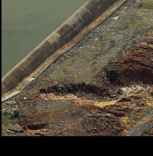
Erosion has created a 300-foot-deep hole in the concrete spillway of Oroville Dam and state officials say it will continue grow.
State engineers on Wednesday cautiously released water from Lake Oroville's damaged spillway as the reservoir level climbed amid a soaking of rain.

Situated in the western foothills of the Sierra, Lake Oroville is the second-largest manmade reservoir in California after Shasta....

Member Spartan: Stage storage flow data here for those interested:

Mike McCann, PE, SE (WA)
 
Replies continue below

Recommended for you

Hopefully, major flooding will not result.

After this is all over, and soon, there needs to be some major redesign and construction of these spillways. I understand that the Oroville primary spillway was supposed to be able to pass 250,000 cfs, yet it couldn't cope with 100,000 cfs. In comparison, the Wivenhoe Dam on the Brisbane River above Brisbane has a reported primary spillway design capacity of 420,000 cfs, and this is on a much smaller catchment than Oroville.
 
An interesting link to the Mercury News discussing how during the last FERC re licensing that the issue of erosion of the spillway was discussed and improvements not undertaken because the water users didn't want to pay the price. Smart move, in that now the taxpayers will.


Obviously, there's a difference in perspective when the event might be imminent.

Perhaps some of the 6+ billion that the the California legislature set aside for dam reclamation and improvements will be tapped - if they can find where that money went. Or since California has asked for Federal aid for the flooding this can just be tacked on to that bill.
 
I finally figured out what the "hole" is. To figure it out I had to
compare several days of video and pictures.

On Saturday (11th) pictures you can see the road that cuts down slightly diagonally to the E-spillway.
That road runs across the entire E-spillway and then back up around to the recreational area.

That road was on a berm to get it level, well not dippy, it had slope. That berm created what is being called
a "catch basin". That basin filled up a couple of hours after the E-spill started. It didn't fill as quickly
as one would've guessed because the whole E-spill was in operation and most of the water wandered downhill
using many different paths.

But fill it inevitably did. Once it filled the rec-road became a secondary spillway. Being sloped though got
some concentrated flow on it and it quickly failed in it's short spillway life. Once the pavement left the
entire berm vacated in a very short time probably around an hour. This translated the "catch-basin" into a
shockingly large "hole" as the people onsite watched. Since this large hole is fairly close to the E-spill
it now gathers the lion's share of all the spill. Of course this focuses the erosion in the hole. At that
point the officials believed the erosion was progressing rapidly back towards the E-spill wall. The reality is
it was probably not as fast as they thought but more of a story allusion fed by the rapid transformation from
catch-basin to hole.

Anyway, the decision to really crank-up the primary-spillway was probably the best idea.

The helicopter rock bag delivery is to fill that "hole".


Keith Cress
kcress -
 
improvements not undertaken because the water users didn't want to pay the price. Smart move, in that now the taxpayers will.

Right! When in the history of public works projects has that result ever been avoided. "Hey, do you guys want to pay for this?", just never seems to work. Then again I suppose nobody ever wanted to increase user fees, or taxes to pay for it either. Can you imagine?

So back to lesson one. No taxes, or user fees (tolls, etc.) = no infrastructure.

Makes me wonder from where the 50 Americas Most Needed Infrastructure Improvements will materialize.
Popular Mechanics Article: 50 States, 50 Things America Must Fix Now

Edited to add this.
OK so this morning I woke up to hear that the USgov debt ceiling will be increased. That fits perfectly with the new administration's plan to build a trillion in infrastructure while they also propose to reduce taxes .... and kick the resulting "No money to fix breaking infrastructure problem" down the road. The more things change, the more they stay the same, just the swamp keeps getting bigger.

Reaction to change doesn't stop it :)
 
Good description and the big hole was probably what caused the initial fear, but this one to me is more worrying.

dam_2_ze1mlt.jpg


what we don't know is how deep the foundations of the wall go and what they are toed into, but much more loss of earth and they are in trouble.


Remember - More details = better answers
Also: If you get a response it's polite to respond to it.
 
If you dig into that data from Spartan5's link, you can see how fast the water was coming into the reservoir. Inflows of 180 to 190k CFS and the lake level was rising almost a foot per hour. Couple that with the recently found (at that time) damage to the primary spillway and you can see how this became a problem so quickly.


6 days of data
 
Looks like more weather is coming. Wonder what they do if there are more huge inflows. They haven't dumped more than 100k cfs from the primary spillway since the damage. There could be a decision between exceeding 100k or letting the emergency spillway crest again.
 
Given the 7 yrs of dry conditions, it's not inconceivable that the soil simply subsided from the spillway, and when it needed to be used, the concrete didn't have sufficient support and simply gave way.

Additionally, it's a bit unclear, after the fact, whether the spillway walls were tall enough. It looked to me that some water was going over the edges of the spillway, which might have hastened the erosion under the spillway and resulted in the gaping hole. I think they were about 15 ft shorter than they ought to have been.

TTFN (ta ta for now)
I can do absolutely anything. I'm an expert! faq731-376 forum1529 Entire Forum list
 
LA Times Page

On this link are the hands-down best dronage I've seen of this whole thing. The first video down the page is actually 5 back-to-back ones. In no particular temporal order you can see the entire E_Spill evolution and the birth of the Hole and it's finger snaking right back up to the spillway. Some have great sound even. The absolute mass of water that came over the E-spill is readily apparent where its not been on any other vids I've seen. It gives a sort of fascinating-horror feel.


The evacuation has ended.


Keith Cress
kcress -
 
azcats, an interesting point. When Wivenhoe Dam in Australia contributed to flooding in Brisbane, there was a lot of scrutiny over whether more water should have been released earlier, and whether releases of water from the dam contributed to more flooding downstream than there should have been.

With predictions of more rain, it would certainly be within the scope of discussions as to how much more water can be released in order to allow for additional capacity in the dam versus holding water in the dam and hoping that the water level won't rise again.
 
A very common issue I'm told (and makes a lot of sense to me) is that these projects are built directly in response to near annual flooding that disrupts everything, damaging infrastructure, and frequently killing people. So with a mandate to stop-the-flooding the project is funded and built. Mission accomplished!

Time goes by and pretty quickly no one remembers the flooding and the original point of the entire thing. Furthermore, operational costs go up and up and up. So in an effort to get the dam to fund itself the dam's mission statement quickly evolves into providing water for irrigation and money thru energy sales. The flood control becomes a side-note.

Any bean-counter looking at it can't resolve operating costs with the state's savings from flooding disasters.

The changed mission demands more of a brinkmanship operation of how full can we keep the dam and can we end the rain season at 100%. This, of course, paves the way for disaster if exceptional rain occurs. Q.E.D.

Keith Cress
kcress -
 
Wivenhoe Dam (and the near-over-topping in 2011) is an interesting case - it was conceived as multi-purpose dam from the start - water supply (a bit over a million mega-litres), flood mitigation (another million and a half mega-litres above Full Supply Level), and pumped storage power generation (about 30,000 mega-litres which can be pumped up to Splityard Creek reservoir and returned in a typical 24-hour cycle).

However, south-east Queensland had been in the grip of a major drought (is anything about this story ringing any bells with the situation in California?) for about seven years, which saw the dam at very low levels, until the drought broke in 2007. Being "drought resilient" was very high in the public and government perception in the years following, so the prevailing wisdom was to let the dam reach full supply level when runoff permitted, and maintain it as high as practical to Full Supply Level.

And then came the wet season of 2011 ...

And we're still trying to figure out the best way to use Wivenhoe for both flood prevention and drought mitigation.

Should we draw the dam down at the start of the wet season, to provide more than 1 1/2 million mega-litres of flood storage? What happens if the wet season "fails", and we hit another extended drought like 2000 - 2007?

Or should we take advantage of the wet season to top the dam up to its nominal Full Supply Level, and live with "only" 1 1/2 million mega-litres of flood storage "buffer"? What happens if we then get another wet season similar to (or wetter than) 2011?

And will these questions become even more crucial due to the effects of climate change? (Will our wet seasons get wetter, and / or our drought years become drier and longer?)

 
Status
Not open for further replies.
Back
Top