Until they investigate the cause of the southeast corner of the tower driveway's 'phenomenon', as to why this area defies settlement; I think they are just asking for trouble. The southeast corner must have a lot of Young Bay mud under pressure. The current tilt tends to confine the mud on the east side, while squishing mud out the west side.
When I look at
Slates ground profile, showing the Colma sand hump, I wonder if the sand hump and the even larger Young Bay Mud 'bulge' are the result of the tower's southeast behavior.
The Marine sands and the Colma sands are both aquifers. The lower Young Bay Mud is only 10 feet thick & very plastic.
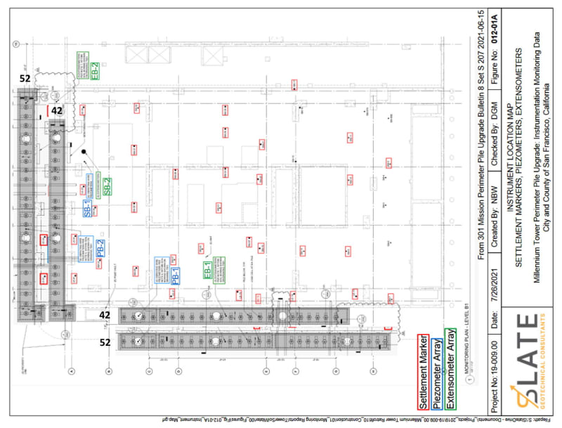
This, from John Egan's June 18, 2021 report of piezometer readings...
Piezometers
Several sharp increases of piezometric head have been observed in the PB-1 piezometer at a depth of 85 feet bgs (located in the Marine/Colma Sands). [highlight #FCE94F]The spike on May 15, 2021[/highlight], between 6AM-12PM corresponds to a known influx of water onto the crane mat/sidewalk during installation of the 36" casing as the auger is retracted and soil is removed. The Building Engineer for the Tower also noted water infiltration into the basement. Similar increases were not observed in SB-1 and PB-2, as these piezometers are not situated close to the source of this water influx.
Additional spikes were observed on May 28, 2021, June 1, 2021, and June 7, 2021, all between 6AM and 12PM, and on June 11, 2021, between 6AM-9AM. The cause of the May 28 and June 1 spikes is not known, but likely is similarly due to an influx of water as described above. The spike on June 7 corresponds to advancement of the 36-inch casing for Pile #27 to a depth of ≈89 feet feet bgs and on June 11, the spike corresponds to advancement of the 36-inch casing for Pile #28 similarly to a depth of ≈89 feet feet bgs and observed water addition; both Piles #27 and #28 are located in close proximity to Piezometer PB-1.
For the piezometers in the Old Bay Clay (OBC), piezometric head at the PB-1 piezometers was influenced (increased) by the installation of the nearby Indicator Piles and has exhibited a general trend of decrease (dissipation) since then. Small increases of the head in the PB-1 piezometers at depths of 105 feet bgs, 120 feet bgs, and 135 feet bgs was observed on May 17, 2021, but piezometers at greater depths were not noticeably affected. Advancement of the 36-inch casing for nearby Pile #25 achieved its tip depth of ≈102 feet bgs on that day. Sharp decreases in the PB-1 piezometer at 105 feet bgs was observed on June 7, 2021, between 3PM-6PM and on June 11, 2021, between 6AM-9AM and 12PM-3PM. The decrease on June 7 corresponds to advancement of the 36-inch casing for nearby Pile #27 to a depth of ≈101 feet bgs and the decreases on June 11 correspond to advancement of the 36-inch casing for nearby Pile #28 to depths of ≈89 feet bgs and then ≈103 feet bgs. The decreases may be result of release of water from OBC into the casing, as the length over which the head loss occurs is much shorter after removing the soil inside the casing. [END]
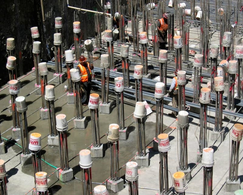
Serendipity would have it that LB Karp was on-site taking pictures on June 15th and you can see the results of the water influx, on hat date.
Photo 1 &
Photo 2
Post from SF tower settlement (Part 1)
BUGGAR (Structural) 23 Sep 18 00:56
Bay Mud really is interesting stuff. The contractor approaching the Lower Market Street Station used a tunnel shield in the Bay Mud and the muck (mud) was routed through the face of the shield through a large tube like so much cookie dough. Of course it was referred to as elephant shi*
My questions, is whether the Lower Young Bay Mud is leaking water from the Colma Sand aquifer, upwards into the Marine Sands, during drilling operations, where the horizontal conductivity is greater and the water more readily disperses over a wider area, resulting in volume loss. This would be around the outside of the casing. Subsequently the Lower Young Bay Mud 'heals' around the casing, shutting off the water leak from the Colma Sands.
![[ponder]](/data/assets/smilies/ponder.gif "[ponder] [ponder]")