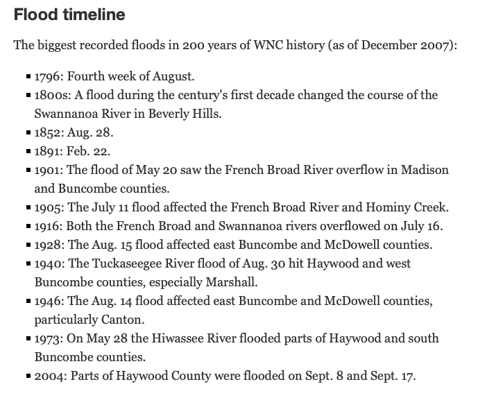
https://en.wikipedia.org/wiki/Hurricane_Camille[/URL]]The storm dropped torrential rainfall of 12 to 20 inches (30 to 51 cm), with a maximum of 27 inches (69 cm).[28] Most of the rainfall occurred in Virginia during a 3–5 hour period on August 19–20. More than 5 inches (130 mm) of rain fell near the North Fork of the Tye River in only half an hour with the grounds already saturated from previous rains.[30] Many rivers flooded across the state, with the worst being the James River in Richmond with a peak crest of 28.6 feet (8.7 m). Many rivers in Virginia and West Virginia set records for peak flood stages, causing numerous mudslides along mountainsides. In the mountain slopes between Charlottesville and Lynchburg, more than 26 inches (66 cm) of rain fell in 12 hours, but the worst was in Nelson County where 27 inches (69 cm) fell. There, rainfall was so heavy that reports were received of birds drowning in trees, cows floating down the Hatt Creek and of survivors having to cup hands around their mouth and nose in order to breathe through the deluge. Though the official rainfall was recorded as 27 inches (69 cm), unofficial estimates are much greater. Some estimate that more than 40 inches (100 cm) of rain fell at Davis Creek. Most gauges were washed away; however, it was reported that an empty 55 US gallons (210 L) drum that was not even in the center of the heaviest rainfall had 31 inches (79 cm) of water in it after Camille passed. "So much rain fell in such a short time in Nelson County that, according to the National Weather Service at the time, it was 'the probable maximum rainfall which meteorologists compute to be theoretically possible.'"