Continue to Site

Eng-Tips is the largest engineering community on the Internet

Intelligent Work Forums for Engineering Professionals

  • Congratulations KootK on being selected by the Eng-Tips community for having the most helpful posts in the forums last week. Way to Go!

FEMA's Outdated Flood Zone Maps 21

Oops409

Mechanical
Apr 25, 2024
193
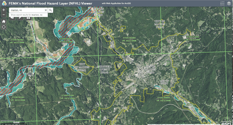
Only 3% of residents in Asheville, NC, for example, had flood insurance, according to an article I read. Looking at FEMA's Flood Maps, it is understandable why residents would not have flood insurance.

FEMA flood maps will need to be updated to reflect modern risks, and risks due to more and more urbanization and growth since maps were developed, along with whatever weather cycles we are now experiencing.
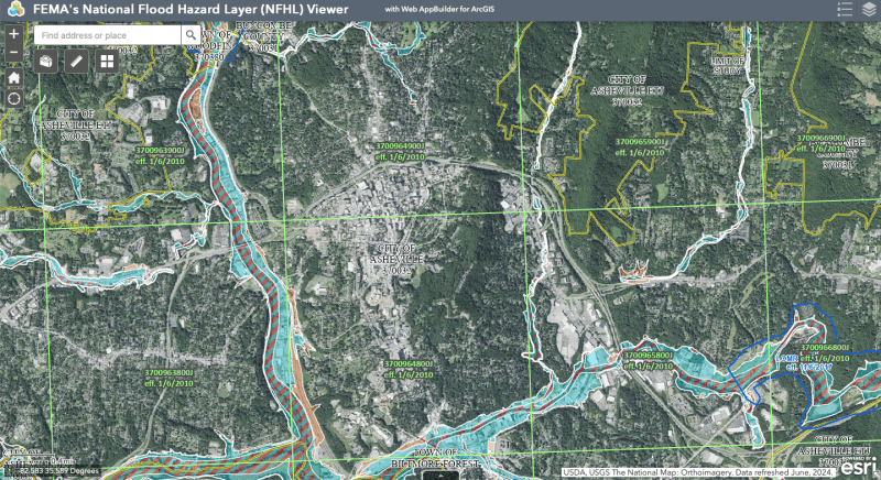
Screen_Shot_2024-10-04_at_2.44.28_PM_ufmkwl.png


Marion, NC below

Screen_Shot_2024-10-04_at_3.06.57_PM_mxaqdk.png


Replies continue below

Recommended for you

Efficiency is king in manufacturing; it's a literal pipeline, not unlike the compute pipeline in a modern processor, and it goes bonkers when something interrupts the flow.

This is coupled with the fact that as manufacturing of any product evolves, fewer suppliers are left, so any single supplier getting knocked out of production results in massive disruptions.

Unless we, as a country, or society, are willing to spend taxpayer dollars to maintain factories that are not running anywhere near capacity to have redundancy, there will be no changes possible, or desirable. The US already tried this in the latter part of the last century, trying to have semiconductor manufacturing capacity for Cold War military applications. The end result was over a billion dollars spent and nothing to show for it now.

The synergy between full-bore manufacturing and its ability to fund innovation was something that was missed in the original concept of that program. Without the driving force of needing more capacity to make profits, innovation doesn't really get much traction.

TTFN (ta ta for now)
I can do absolutely anything. I'm an expert! faq731-376 forum1529 Entire Forum list
 
Yes. Alternate facilities will reduce economic efficiency. We will have to accept a higher price, not necessarily provide funds for duplicate facilities with tax dollars. There are solutions to things that do not involve increased taxes.

In cases where duplicate facilities are not practical, the solution might be to go Dutch and build a dike around them, for example. Or maybe to stockpile these products in multiple locations. If tax dollars are not provided to do that, we should expect to pay a higher price for the product. If the product would be rendered uncompetitive as a result, then recognize facts, raise an endangered production facility alert for a critical product and limit their market share to the risk limit. We cannot be left exposed simply because a critical product is being produced artificially cheaply because of lack of proper mitigation against floods, landslides, earthquakes, or other disasters, natural, or manmade. Or is the object going to be to live on the edge of any potential disturbance? Haven't we learned that "To big to fail" is a dangerous way if life.

.

--Einstein gave the same test to students every year. When asked why he would do something like that, "Because the answers had changed."
 
As we saw in Drena, the topography matters in heavy rainfall events:

I think that there was a certain amount of underestimating that occurred by those in power and those on the ground. I work north west of Atlanta and before the storm hit there was a large amount of downplaying that came from upper management at my site the day before it made landfall as well and after. We were open for business and expecting 1st shift to report in at 6am. Some of the managers had to leave later since the power then went out at their houses and they needed to get their generators running....

When camping, they always tell you not to put you tent in the flat near a stream or even in a dry gully as it may rain uphill and become a washout. I would say rather than requiring flood insurance for everything that fall along a creek and river, it would be better to model how much upstream rainfall can occur before you see the flooding at a given location. As the area has become more developed, runoff and reduced permeability is adding greater effects.
 
FacEngrPE said:
I first experienced kind of event during Hurricane Camille, watching all sorts of material float past on the Potomac River, downstream of the storm impact area.
I lived up near there as a kid in 1972. I remember when Agnes came thru and they made us shelter at the high school due to a chance of flooding. Even back then and still today I knew there was no chance in hell our neighborhood was going to flood.
 
Then there are places in my area where the same neighborhood have been hit multiple times from the numerous tornado's over my lifetime. The path typically hits one particular rural subdivision repeatedly, while not hitting any other subdivision twice. Usually path is parallel but shifted north or south each time.

Because insurance only pays out at a fraction of replacement costs if you don't rebuild, the houses in that subdivision always get rebuilt, and sold to a customer new to the area.

For locals it is well known stay away from that specific neighborhood......
 
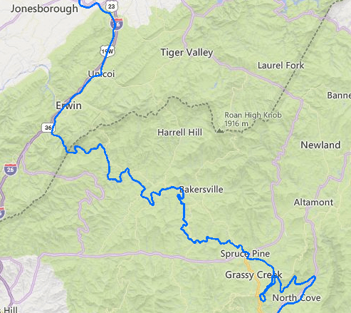
CSX Transportation’s ex-Clinchfield Railroad mainline along the Nolichucky River is in need of substantial rebuilding. Just like I-40 the route is dictated by the grade, the alternative would be crossing the mountains by tunnel as in the new Gotthard_Base_Tunnel, which is 53 miles long. Tunnels this long have only recently been possible, and tunnels this long only work for thru traffic. Time to construct 17 years, time to arrange funding may have been longer.

Here is the best current description of the Nolichucky River corridor. Stew Winstandley Sep 28 #713 Approximately 40 miles of railroad have washouts; region is still largely inaccessible

Regarding the problem with IV Fluids,
Baxter released "Hurricane Helene Updates, North Cove Strong, DEERFIELD, Ill. - 2024-10-07" Short story is that a temporary bridge has been installed which allows access to the site, so repairs have started. They expect that it will take 2 weeks before they will be able to announce a plan to restart production.
 
Flood zone, or flood insurance only covers the structure/mortgage holder. It is not a very good plan/system for the home owner. It is the people who get hosed in these events.
But there is such a great need for homes, because of the number of people, that it is herd to leave that much land empty.
Unless the homes are built up higher, but that makes them more susceptible to wind.
Maybe a better use of these places is apartments, with the ground floor for parking/floodway.

In more rural areas the floodways are used for crops, with the knowledge that every 50 or 100 years the crop will get washed out (which people forget about).
 
Building in flood zones, on stilts or otherwise, is just not a solution. It only increases the problem with more rapid runoffs from impermeable surfaces and would probably interfere with flood water flows. Flood channels may solve a local problem, but usually increase troubles downstream. Crops and recreational areas are a far better solution. Water retention methods may work in some areas; Houston has relyed on those, but the best may be to build nothing at all.

--Einstein gave the same test to students every year. When asked why he would do something like that, "Because the answers had changed."
 
Bike and hiking trails. Pick nick areas, and parks. Or even roads, and parking areas.
Power line corridors.
 
You were good, up until roads, parking areas and power lines.
Around here many parked cars get washed down to the ocean.

--Einstein gave the same test to students every year. When asked why he would do something like that, "Because the answers had changed."
 
Power lines can be underground, or overhead on peers. I have seen many of them like that.
Roads and parking areas can be blocked off, like special event parking, or secondary roads (named floodway).
 
Underground and overhead utilities were both washed away/ damaged by Helene in North Carolina.

Cranky, I assume by piers you mean a pier foundation deep enough to survive perhaps 20' or more soil errosion as seen on " Creeks" in North Carolina Mountains?

Who is gonna pay for this expensive hardening of infrastructure for a 1 in 1000 year event? Especially on narrow rural mountain roads along a creek bed. Further there is a lot of rock to deal with. Very narrow creek valleys, where cutting into rock mountain is required to shift roadway/infrastructure outside of flood zone.

With enough money and determination anything is possible. Perhaps cut into mountain for new roadway, and use spoil to created a stepped creek flood plain, so that normally small creek flows at all times and the the eco system flourishes again, and there is flood plain overflow area designed in. Damage will still be expensive no matter what, next 1000 year event!

Perhaps a lot like living on the coast, just events are spaced much further apart.


Paving would worsen both runoff and flow rate. Leave them grasses, if you must have parking. Cables (and pipelines) always cross stream beds as perpendicular as possible. Following the waterway is kind of asking for it. Roads the same, as like an "Irish crossing" perpendicular kind of works, but it is a high maintenance item. Generally the best parallel route is above flood stage and outside river banks. A pipeline or buried cable is almost guaranteed to wash out. We don't even like to run them downhill. You have to make concrete sack dams in the ditch to hold back water that always makes it down into the backfill and runs along right next to the pipe, which washes out the sand bedding first, then the backfill colapses down into that stream, or the pipeline floats up. Big mess. Actually routing buried stuff in mountains works reasonably well following the tops of ridges. If we cross a river, it's buried below scour depth, or we do a suspension bridge. Problem is that these kinds of floods, created by twice the recorded rainfall, will increase scour depth. The answers have changed.

--Einstein gave the same test to students every year. When asked why he would do something like that, "Because the answers had changed."
 
Who is gonna pay for this expensive hardening of infrastructure for a 1 in 1000 year event?[/quote said:
With climate change, this could become a weekly event; only time will tell.

-----*****-----
So strange to see the singularity approaching while the entire planet is rapidly turning into a hellscape. -John Coates

-Dik
 
If so, according to the book, the end of times are approaching.........?
 
or maybe just another mass extinction?

-----*****-----
So strange to see the singularity approaching while the entire planet is rapidly turning into a hellscape. -John Coates

-Dik
 
Everybody has an end of times at the moment they die - natural causes or otherwise. Just my opinion - no item is a harbinger of doom.
 
How do we manage risk in earthquake zones? We don't try to stop slow the motion of the techtonic plates.
 

Part and Inventory Search

Sponsor