Eng-Tips is the largest engineering community on the Internet

Intelligent Work Forums for Engineering Professionals

FEMA's Outdated Flood Zone Maps 21

Oops409

Mechanical
Apr 25, 2024
187
0
16
US
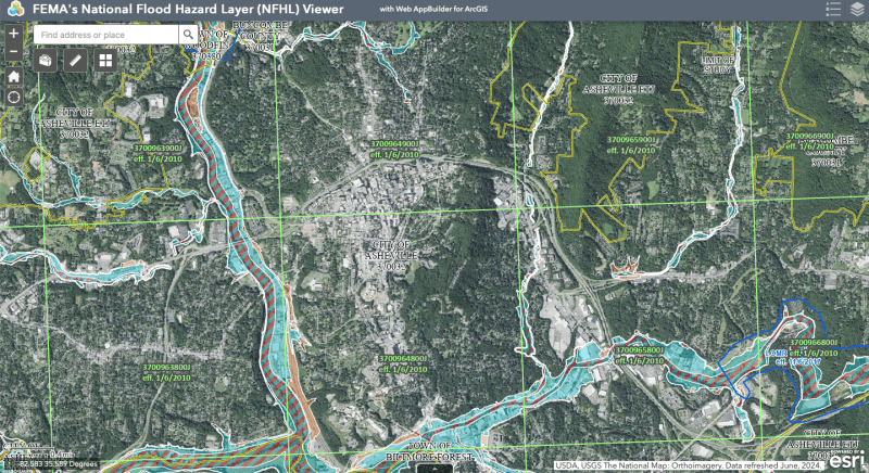
Only 3% of residents in Asheville, NC, for example, had flood insurance, according to an article I read. Looking at FEMA's Flood Maps, it is understandable why residents would not have flood insurance.

FEMA flood maps will need to be updated to reflect modern risks, and risks due to more and more urbanization and growth since maps were developed, along with whatever weather cycles we are now experiencing.
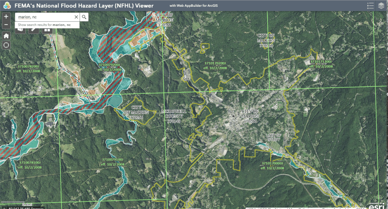
Screen_Shot_2024-10-04_at_2.44.28_PM_ufmkwl.png


Marion, NC below

Screen_Shot_2024-10-04_at_3.06.57_PM_mxaqdk.png


Replies continue below

Recommended for you

Tug - your posts can't get any stupider? There's no point being politically nice when you're posting complete idiocity to purposely argue with others. I'd say go back to the pub for this kind of stupidity, but you posted so much complete crap you got banned from there already.
 
Tug, you are suppose to accept the proganda, without questions, so you will be considered for Team Canon Fodder!

BTW, the US did Not require Covid "Vaccines" for illegal immigrants to enter the country, but famous foreign tennis players were considered too high of a risk and rejected without proof of 'Vaccine'.

I am sure there was a 'Scientific' reason?
 
Which begs the question, does a molecule of water occupy a surface area or a volume?

That's irrelevant to the OHC question; it's not a first principles physics presentation but a derived concept for use with maps, which nearly every engineer here understands.

It's no different than R-value, with units of K-m^2/W, even though insulation always has volume. R-value is a synthetic construct that buries the thickness and thermal conductivity of the insulation into the presented value to make it easier to compare insulation and determine the required type of insulation. This is 1st year heat transfer stuff that's taught in physics and repeated, if you actually took heat transfer.

TTFN (ta ta for now)
I can do absolutely anything. I'm an expert! faq731-376 forum1529 Entire Forum list
 
There aren't any requirements for illegal entry. Suggested: know how to swim.

--Einstein gave the same test to students every year. When asked why he would do something like that, "Because the answers had changed."
 
If it is the total energy below the unit of area that can't be known because there are only comprehensive measurements of surface temperature. We have a centuries worth of bucket dips but the sampling rate isn't high enough to make meaningful trends.
 
Resources

MTG SATELLITES (Yes Seriously MTG [clown] (Meteosat Third Generation)

ARGO FLOATS

statusbig_qne4ur.gif


How Do Floats Work

NATIONAL DATA BUOY CENTER


EUMETSAT OCEAN MONITORING
Sentinel 3
Sentinel 6

Atmospheric Composition MONITORING

National Weather Service
Model Guidance


"
--Einstein gave the same test to students every year. When asked why he would do something like that, "Because the answers had changed."
 
What's the elevation difference of the uplift, +/- 1500ft?
The valley behind and along the ridge looks a lot like the Derna, Libya topography that washed out last year.

--Einstein gave the same test to students every year. When asked why he would do something like that, "Because the answers had changed."
 
Elevation at Rutherford NC ~ 700 ft (Piedmont)
Walnut creek at green river - 800 ft (downstream end of gorge)
Adjacent Blue Ridge escarpment - ~2500 ft (typical)
Adjacent mountain tops ~ 4000 ft.

This is enough elevation change to wring water out of clouds.

Elevations from USGS Topo builder

The NOAA atlas 10 precipitation data may understate the higher end of the possible rainfall rates.

1000 year 1 hour = 4.92"
1000 year 24 hour = 10.1"
1000 year 3 day = 11.6"

Maximum observed was in excess of 20", and could have been as high as 30"
 
had a chat with a work colleague who in a previous career used to be involved with similar were I am.

You guessed it, industry has a huge input politically and socially.

Basically a change in these maps can have a colossal change in land value.
 
2500 -800 = 1300 ft. =+/- 1500

From my local weather experience with a 1500 ft vertical cliff to long ridge at the top only a mile away that its enough to drop the temp 1.5°C 3°F and that will condense and dump a big share of the water vapor. I figured the same happened at Darna. They also have a large and long catch basin paralleling the ridge that drains into and through the city.

--Einstein gave the same test to students every year. When asked why he would do something like that, "Because the answers had changed."
 
Found a study on improving the heat transfer prediction at the air/ocean interface.

Heat transfer occurs at the air water surface interface and is primarily driven by evaporation. The latent heat of evaporation of the water mass transfer through evaporation at the interface, as affected by wind speed and the temperature difference between the bulk air flow temperature and ocean surface temperature, increases the temperature of the air above. The air typically rises to condensation level, where the latent heat of condensation is released kicking it upwards again, while dumping whatever water it can.

The result is J/m2-s, or W/m2 as most of us agreed quite some time ago.

--Einstein gave the same test to students every year. When asked why he would do something like that, "Because the answers had changed."
 
 https://files.engineering.com/getfile.aspx?folder=386a0be8-c9ff-47c5-9fd7-c87b18001f93&file=komori_gtws2010_2011_(1).pdf
For public safety reasons, political intervention in the flood map production process must be prohibited. Arguments based on the technicals alone. At least that's the stated FEMA policy.

They should be based on latest rainfall data @
Precipitation Frequency Data Server

--Einstein gave the same test to students every year. When asked why he would do something like that, "Because the answers had changed."
 
I think that's what they say everywhere... How true that is I really don't have a clue.

Its one of the colossal complaints that some have about EU policy and institutions. They tend to do the right thing in a technical manner with absolutely zero come back from those locally affected.

Some have said it has caused the complete destruction of communities.
 
I've noticed that a lot of provinces don't even follow their national laws, never mind EU regulations.

--Einstein gave the same test to students every year. When asked why he would do something like that, "Because the answers had changed."
 
Basic insurance? If you are referring to flood insurance, it is not basic, it is additional, and FEMA maps seem to set the basis on if you can purchase it. Same with volcano insurance.
I feel that anyone who believes they have a risk should be able to purchase it. But if the maps show a low risk, then the cost should be lower. Thus, it would spread the risk around, and include a larger pool of customers.

That said, why is flood insurance so rare? Maybe some companies went broke from having too much risk in there portfolio.
Truthfully about the only people who purchase flood insurance is those required to by there lender.

 
Why is flood insurance so rare?
It doesn't sound like an insurance money maker.
If it was, it would have an ample supply.
Hard to buy what's never offered.

** 404 Page Not Found **
So it seems the US National Climatic Data Processing Center
is temporarily out of action. Why?
Their building is in Ashville, NC.
Opps!

We're getting rain! First time in 2 years.
It's been going to Morocco.

--Einstein gave the same test to students every year. When asked why he would do something like that, "Because the answers had changed."
 
Back
Top